

To display the site correctly, please, enable JavaScript.
Chapter 1: Mysteries of the origin of the relief
| << Previous | Table of contents | Next >> |
A very long time ago it was noticed, that megaliths worldwide are located near to seacoasts. This regularity is best of all expressed in Ireland, England, the Western Europe, and Korea, but there are still no explanations, why it is so. In the majority of these places, the megaliths are confined to seaside hilly plains, on which they practically always appear on small heights.
I do not know, if this occurred to anybody, that megalithic gigantism can be caused by the fact that these constructions resisted water. But even if this thought occurred, it hardly lingered for a long time because some megaliths are found at the height of tens and even hundreds meters, and even the bravest heads could not assume such rising of water or a land considering the absence of generally accepted traces of this process in geology. The modern assumption of scientists that the sea level in the Neolith was not above, but even below the present day level did not promote such guess either. This assumption is based on the proposition that melting of glaciers should inevitably lead to increase of a water level of the great oceans. The logic is simple − if then there was more ice on the land than now, hence, there was less waters in the oceans.
Existing geological views at the modern history of the development of the Earth did not offer researchers of megaliths any other possibility of their location in the past, except for that which they, in general, occupy now. Only small individual changes are allowed. The inaccuracy of these presuppositions explains why this mystery has not been solved for so long.
Let us illustrate the problem with a chart located below (Figure 1.1). A sign «ТТ» points to the locations of megaliths.
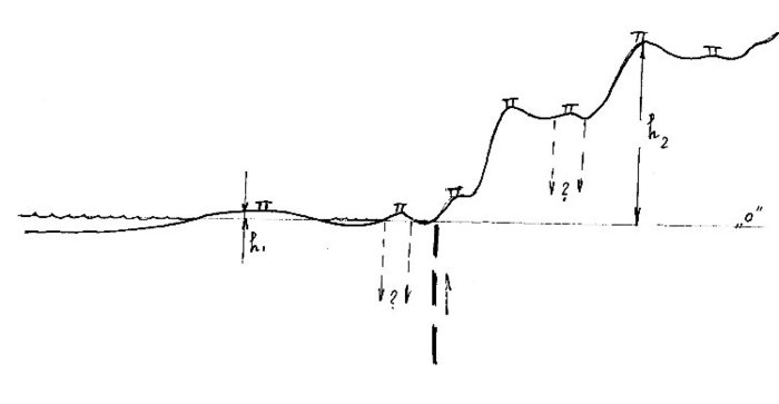
Figure 1.1 − A chart of a usual arrangement of megaliths on a regular relief.
Let us assume, that we, for any reasons, believe that megaliths are constructions, the existence and functions of which is closely connected with water reservoirs. Indeed, it is easy to assume when looking at their appearance. They are massive, hence, steady against waves. They are made of stone, hence, will not decay in damp conditions and will not be washed away even being fully submerged. Blocks, from which they are assembled, often are rounded like coastal boulders that can testify of the influence of waves.
If we go further and not search for a place, where near each one of them could be that very water in the form of a lake or a river, and assume, that they were established on coast, on dewaterings, then we will face another problem. We will have to explain how could that rough surface, which is presented in figure 1.1 be at the sea level and represent plain just in very recent times. It is unlikely that a sane person would assume, that the rise of the water level a few thousand years ago could reach hundreds of meters (up to h2) approaching to most highly located megaliths. Besides, such submerging would make completely senseless the construction of megaliths located on lower levels (h1). That is, the manipulation with the sea level to which geologists often resort in order to make ends meet in their constructions will not help us here. The only possible way of explanation could be in tectonic forces that led to raising or lowering of separate parts of the Earth surface. It is not be possible to use for this purpose tectonic failures along which these transformations can take place, in the form, the majority of geologists represented them, since usually it is supposed, that the pressures generating them lie very deep, somewhere under the Earth crust. Then they can explain only vertical movements of large territories, − of tens of kilometers in size, comparable with the thickness of lithosphere. With the reference to our figure, they can be assumed on the interval where one can observe jump changes in the character of the relief. That is what geologists usually do.
But the occurrence and growth of separate small hills some tens or hundreds of meters across cannot be explained this way, − in fact one will not pull the system of tectonic cracks along which rising or lowering could be taking place from under each of them downwards for tens of kilometers to the mantle.
Thus, the assigned problem of transformation of plain into a finely disjoint surface by tectonic transformation cannot be solved without some tricks from the point of view of classical geology.
The basic scheme of how the origin of such type of surface is usually explained nowadays is being presented in figure 1.2.
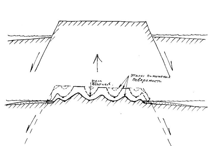
Figure 1.2 − Classical presentations of the origin of the relief.
Everything begins with a statement that a certain part of the sea bottom rises and turns into land because of tectonic processes. Having got into the zone of the influence of the sun, wind, frost, and water the Earth surface starts to deteriorate. In some time, there will appear ravines, and then and branched river valleys, and on the shores of the sea, the waves will form cliffs, banks and terraces. Millions years later on the place of raising we will see finely disjointed surface surrounded by the sea and on the seabed there will be everything that was carried there from the land.
It seems so natural and obvious, especially observing the destructive consequences of river stream rises or surfs that the doubt does not even occur that it was not the rivers and streams that had generated those depressions where they flow, and not the sea had formed coastal cliffs and terraces. Geologists are also guided by almost the same simple logic. Consequently, all material collected by geological researches is unconsciously arranged under this scheme. If there are any discrepancies (e. g. whether that or this valley is too big for a stream flowing there, or whether terraces in mountains are too high for a possible sea level in the past) there are lots of ways to explain them in the geological arsenal. Some involve tectonics, others write off all of them for a different climate in the past, etc. To find out how it actually was, even through wanting to, is not easy, and often quite impossible.
It is clear that accepting such scheme of the evolution of the Earth surface, the modern location of megaliths could not be essentially different from what it was 4-5 thousand years ago when they were being built. They should have kept approximately the same height above the sea level, and the same difference of heights among themselves, plus or minus a few meters allowed for the change of the ocean level and concealed tectonic movements.
Such understanding of what was going on has determined the indifferent attitude to megaliths on behalf of the majority of the geologists perceiving them as superimposed, clearly archeological object to be studied not by them but by corresponding experts. Maximum, geologists studied and defined rocks presented in blocks and searched for places of their outcrops. However, such correctness, creditable in other cases, has played a fatal role at the crossing of these two disciplines.
Figures 1.3 and 1.4 present the scheme of the relief formation based on the principles used by me. It is not possible to prove this hypothesis in details within the limits of this article. It is a rather long and boring story in no way connected with megaliths. Therefore, a reader will have mostly to accept on faith the assumptions made. (NB: I will only tell that this theory was born about twenty years ago during my work as a geologist in the Arctic Regions, and all subsequent time I was getting more and more affirmed in its rightness). Despite of it, after reading of the whole article every reader will have a right to draw a conclusion whether presented assumptions were appropriate or not. If it suddenly appears that they become those missing parts helping to explain many features of megaliths, that would mean that the equation is solved correctly and we will finally understand what these constructions are and will be affirmed in the necessity of revision of many basic doctrines in modern geology.
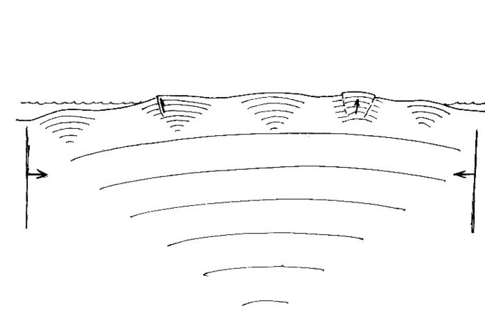
Figure 1.3 – Cross-section of the relief before activation of compression.
So, as well as in the previous case, a part of the seabed experienced rising and came to the surface in the form of low plane with small hills, hardly standing out of water (fig. 1.3). This is how, I assume, these places looks during the construction of megaliths. Most likely, this is how most of the Earth surface looked during the whole Cenozoic until recent time, because the deposits, which were coming from the land during this period, are presented by clays. These deposits point to a slow character of deterioration of the land, that usually takes place in cases of a low flat relief without fast rivers and steep rocky coasts.
These hardly noticeable sloping heights and lowlands represent structures of distortion (deformations) of the Earth surface, something similar to folds. They were caused by horizontal (lateral) compression, which embraced back then and is still embracing now all firm layers of the Earth. Under the compression the relief slowly developed: “positive” structures grew upwards, “negative” − downwards.
As in the case of usual folding, structures of distortion form on the surface a multilevel hierarchical system, in which larger structures are complicated by smaller one, those in turn − by even more smaller, and so on … ad infinitum. Being imposed upon each other (interfering) according to the laws of wave properties of matter studied in the school course of physics, their amplitudes were added and subtracted forming all that complex set of relief forms vertically and in plan, which we can observe in the nature.
This period is characterized not only by flat, often swampy land (think of numerous turf moors that remained from very recent times), but also shallow character of the surrounding seas which were not quite such as they are now. Drains of water from the land essentially desalinated them, and small depth did not promote good water exchange with salty waters of the ocean. Such conditions are always bad for the development of water fauna. It either essentially degrades or disappears absolutely complicating for geologists the definition of age and genesis of deposits.
The coast in such conditions was not as well defined as it is now. It was lost in numerous islands, shallows, reedbeds and seaside marshes (swamps) turning from a coastal line into a coastal zone. Any rise of a water level, whether incoming tides or floods, was accompanied by flooding of extensive territories of coastal lowlands on which “positive” structures turned into islands and shallows, and negative turned into sea channels.
So it all this existed till the moment when a certain event happened to the Earth causing intensification of horizontal compression and consequently collapsing activation of the development of the above mentioned deformation structures of all levels (Figure 1.4).
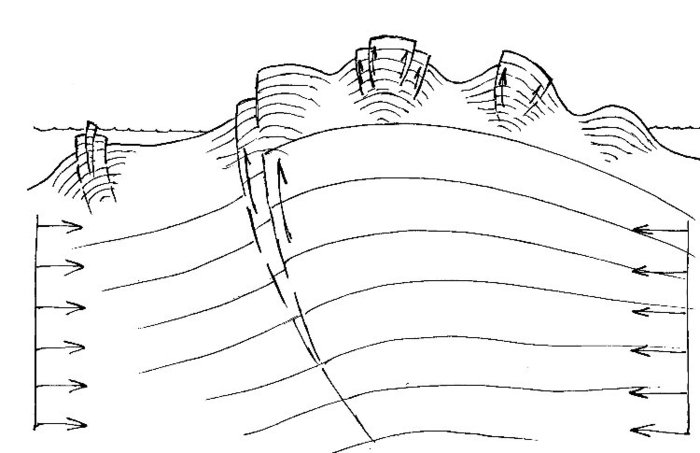
Figure 1.4 − The relief after activation of compression.
Having begun with the finest structures, which grew on the surface in a form of small hills similar to goose bumps, this process involved much larger and deeper structures, sometimes drastically altering seaside plains. Amplitudes of vertical moving of the arches of big structures could be hundreds of meters and even kilometers.
Thus, all those structures and traces of people’s activity living on these low territories in some cases were lifted up to such heights where it is impossible to assume their connection with water on the basis of modern views that attribute the leading role to fluctuation of the ocean level or vertical movements of large territories.
Unfortunately, the deposits that were laid on such territories, according to the above mentioned reasons, only in rare cases allowed to come to conclusions in favour of the occurred raising and its rather young age.
The strongest phase of this reconstruction, which on separate territories was accompanied by catastrophic raisings and lowerings (see the article about cart-ruts on Malta), apparently lasted not very long − years or decades. Here and there, something rose, and something went under water. In due course, the process began to fade, the catastrophes gradually had gone to the past, and it acquared quieter and imperceptible character, similar to what it was before activation and that takes place now.
An important point is that rising of each “positive” and “negative” structure in the area of lateral compression had both general and individual features. On the one hand, finer structures rose or fell according to character of movement of a bigger structure, on which they were located, and on the other hand, each of them developed in conformity with its own ability of reaction to external force. Some of them "sat" there for a long tome not showing the pressure, which have arisen in them, others "moved" upwards right at the beginning of activation process. Even in the past, the heights of identical size located beside each other could have different speeds and amplitudes of growth. The one, that was once lower, could become higher than the other one, or could not. There is no exact proportionality in this phenomenon.
Another very important thing for us is that activation of compression, first, intensified the manifestation of already existing deformation structures. The place of their laying specifies where «a weak link» was. Therefore, it is quite natural that the subsequent compression will be realized in them most strongly.
Thus, the offered mechanism of the relief formation allows to understand how megaliths and cart ruts (a phenomenon of the same period) could "run up" onto heights and to appear at their present locations, sometimes at rather impressive amplitudes of rising, although earlier they had been on one level and in the same conditions. Tracks identical to those on Malta are found out in Portugal in the limestone at the height of more than 800 м (see www.Ancient-Wisdom.Co.Uk), and in the Swiss Alps, on Julier pass the series of similar parallel traces are located even higher − at 2100 m (see www.viastoria.ch).
Very roughly, the basic difference between the new approach and the standard one consists in the following: in former case, the formation of the relief forms of any sizes from small to great occurs due to their upward growth, while in the latter case, from top downwards − due to the destruction and carrying out of material. The main paradox of this version is that the rivers flow where they flow not because they developed these valleys in the rocks during millions of years, but because the hills and mountains, which grew around, left only these ways for a drain of rain and snowmelt water. Rivers’ own activity at the present stage in most cases is limited only by their channel part, though this activity frequently reaches rather impressing scales.
Malta is a good example illustrating this scheme of the relief development. The tracks, by the fact of their existence, point to the presence at a certain moment in the past of the covers of deposits, which had not hardened at different hypsometric levels and on different elements of the relief: at hilltops, on slopes, and in lowlands. This situation cannot be explained by anything other than by fast transformation of low swampy plain into a hilly terrain. It was in the places where the ways of people moving to new residences after catastrophic reorganization of the relief crossed areas where deposits were still plastic, and it was the bottoms of recently drained lakes and bogs, where numerous prints and traces of carts were left.
A well known place on Malta − Clapham Junction (see the Internet) where on a small site located at the height of nearly 240 m one can see tens of pulled together parallel and crossing ruts − was the main stumbling-block in understanding of their nature for many generations of researchers. All of them who perceived the tracks as a result wearing of the bedrock foundation due to repeated transport passages or as something hollowed in the rock, could not explain why there were so many of tracts on such small bandbox. Only the understanding that these tracks are hardened prints made everything fall into place.
Now, having taken into account our position concerning the location of megaliths in the relief it is possible to move to the main part of the article.
| << Previous | Table of contents | Next >> |


