

To display the site correctly, please, enable JavaScript.
Chapter 5: Menhirs, dolmens, tumuli.
| << Previous | Table of contents | Next >> |
In spite of the fact that this chapter concerns three kinds of megaliths, it will not be long. The analysis of the relief, which allowed us to understand many features of the structure of barrows and alignments, does not get us anywhere in this case. I could not find other criteria besides that all of them were established on local heights. Within the framework of existing «picture of the world», this allows to say only that these megaliths during flooding appeared on islands or shallows. Probably, nothing more was required of them, but it does not make the task any easier for us.
In this situation, we have nothing to do but to pay attention to the features of their structure hoping that they will bear some practical sense in a view of our assumptions. This is we are going to do in this chapter.
Dolmens
What these constructions could be? The answer is obvious − dwellings in which people temporarily lived when going out to dewaterings for some purposes. They were some kind of the Stone Age fishing huts. Their arrangement on hardly noticeable raisings on the plain was determined by the fact that they got flooded in last turn, only at the maximal rising of water.
Nevertheless, the way we can see them they do not look like human dwelling. Rough big stones with cracks between them could not protect from cold, wind, or rain. What kind of huts are they?
The matter is that dolmens are not dwellings themselves but only their carcasses, which could be quickly enough transformed into habitation by means of improvised materials. For this purpose, one had to cover them with some vegetative waste, which the sea cast ashore. Only if there was enough of that waste. Then a dolmen turned into a cave in which one could hide from wind and rain. Quite possible, that it was even warm because the damp waste piled on the top and covered by soil, when decaying could warm up as compost, creating inside the condition similar to that of a greenhouse.
Covering or turfing by such material allowed the existence of practically any cracks between stones of the carcass. Even in the case of a tabletop dolmen with practically no walls present, but only supports, a competent laying of plant residues provided preservation of inhabited space under a covering plate.
Using stones at the construction was determined by purely practical reasons. They did not decay and or spoil with time. Due to their heavy weight, they withstood flooding and waves. In places where the surf was especially strong, they could use for the construction of dolmens the largest and heaviest blocks, in more quiet places − lighter and smaller ones.
Sometimes dolmens almost up to a roof level were stoned on all sides by small stone fragments, which created hills around them. This, on the one hand, prevented underwashing of the foundation of blocks by waves and protected sidewalls from the wind, and on the other hand, additionally increased the height of the elevation on which a dolmen was built, allowing using it as an island. Probably, the further development in this direction led to creation of tumuli.
Adaptedness of dolmens to flooding is revealed in floor structure as well. In all cases, that I could see it had an inclination towards exit and was covered by stone plates. All this could provide fast drainage of a dolmen after water left and prevented accumulation of mud when being used.
Alternative dwellings, which could be quickly made by people without extra expenses, are dugouts and hovels. In the conditions of dewaterings both kinds are disposable. After flooding the former will either fall off or turn into the hole filled by water, the latter will simply collapse.
The scatter of orientation of entrances of corridor dolmens in the range from SW up to E challenges the existing version of their ritual purpose. The setting in space of cult constructions is usually strictly regulated (even now at burial people usually adhere to a certain direction of a body arrangement, let alone the positioning of churches). At the same time the prevalence of southern and southeastern directions can specify, that in the morning people preferred to go out into the sun and did not like cold northern winds to which dwellings were turned by "back". The absence of uniform, optimal in relation to the sun direction of the arrangement of an entrance could be caused by one more factor, important in conditions of flooding, − the direction of the breaker in the given particular place. This, as they say, depends not only on the wind, but also on the spreading and character of the coastal line to which the wave, no matter from where it comes, usually tends to turn by front. It is obvious, that the steadiest arrangement of a corridor dolmen − the longest part positioned perpendicularly to the wave front. In this case, the stones turned to the wave by their end are exposed to minimal influence. On the contrary, at the approach of the wave from the side dolmens were exposed to the maximal influence. For a construction, which could be flooded, most likely, this should have been taken into consideration. An existing orientation of corridor dolmens can also point to the prevalence in this region the winds of southeastern direction − the directions, which is also supported by the arrangement of alignments.
Unfortunately, it is clearly speculative, "closet" conclusion. I did not have an opportunity to assure myself of the reality of existence of this factor, because now it is difficult to establish what could be a character and a direction of the coast in this or that place before. For this purpose, it is necessary to carry out a more detailed research.
It seems that one more thing points to the opposition to the wind and waves. Pay attention to figure 5.1. The majority of covering plates incline towards the exit. Such structure that is similar to a cap pulled over one’s eyes, is quite usual. It can be seen in photos presented in chapter 2 in figures 2.2 and 2.4. Such laying reminding fishscale can provide greater stability of the plates during the unquiet. Incoming waves (in this case from the left to the right) will not raise and wash off such plates, but only press them.
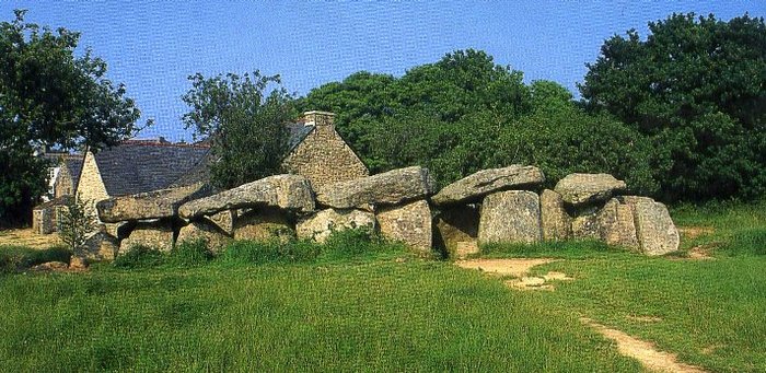
Figure 5.1 − Corridor dolmen. (A photo from “The megaliths of Brittany” by Jacques Briard, Giseserot editions).
It is interesting that some dolmens still have the rests of low framing walls from stones buried in the ground (Figure 5.2 a, b, c). As a rule, they are located near modern seacoast, sometimes directly on the coast. In all presented cases, the space between the walls and the dolmen is not filled by anything. It seems to me, that the purpose of this fencing was protection of the covering made of floating vegetative waste by which the dolmen was winterized against washout by the waves at the rising of water. Naturally, the waste has decayed over the time and consequently nowadays the wall around the dolmen reminds rather a fence around of the house, than the remains of once a uniform construction.
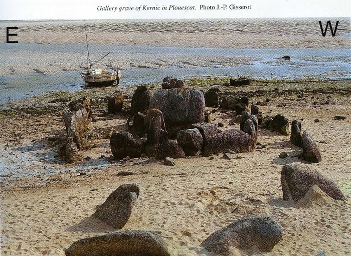
Figure 5.2a
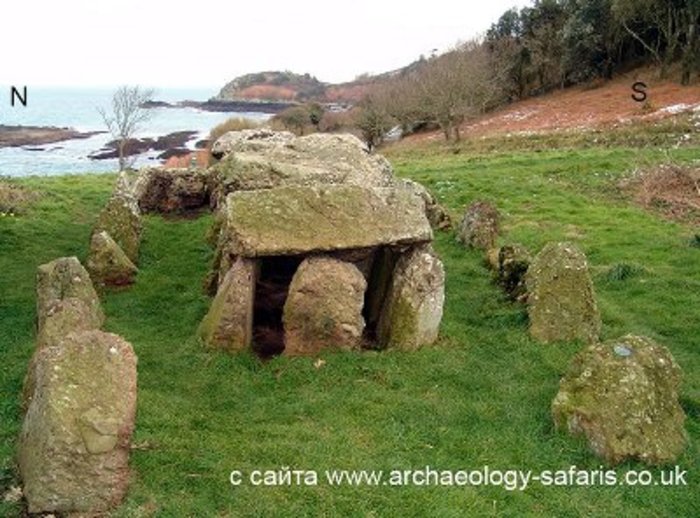
Figure 5.2b
Figure 5.2c
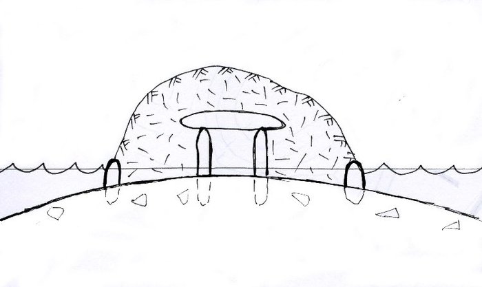
Figure 5.2d
Figure 5.2 a, b, c - dolmens with a protective wall. d – a dolmen with a cover during the flooding.
Their closeness to the modern coastal line specifies that on such opened from the sea sites the necessity of protective surfacing from the waves was the greatest, unlike with those that were located farther into the dewaterings.
Tumuli
In Brittany, they are found essentially less often than dolmens.
The modern location on the heights also specifies that in ancient times they were built on the highest places of flooded plain.
Terrace form and the fact that they are made of stones instead of soil are the consequence of that that at rising of water they turned to islands on which people could survive the flooding. The presence of horizontal levels made it possible to use the whole surface of tumulus. It was convenient to walk on them, as nothing rolled down. Behind their ledges, it was possible to make a fire, to hide from the wind and to settle down for a night. Here on the flood-free surface it was possible to store supplies of fuel and food. The side surface of terraces is characterized by denser stacking of stones and by a little bit bigger sizes.
One of their modifications attracts special attention by its structure (Figure 5.3 and 5.4) − it is tumuli from Ireland, that from outside remind hills overgrown by grass. At the bottom, stones are forming an original belt surrounding them. It quite could be an architectural ornament, but could also serve as a protection against washout of walls at flooding. If the latter is true, then the small height of a belt specifies that water did not rise very high − only 20-30 centimeters.
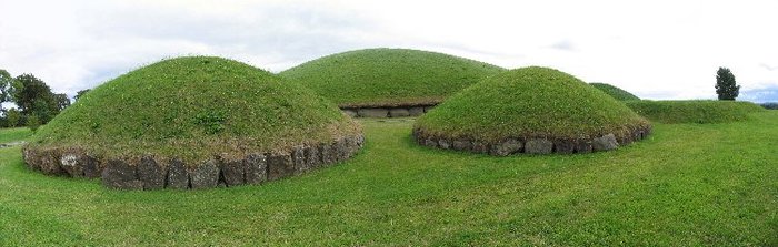
Figure 5.3 − Tumuli from Knowth group. Ireland. (A photo by Markus Bohm №6067304 from Panoramia).
It is interesting, that near some tumuli, and in particular, at Gavrinis located on one of islands of the Morbihan gulf, wooden piles hammered in the ground were found out. Figure 5.4 presents their arrangement according to what was preserved in the ground. In our system of representations, these could be passageways or landings to which boats or rafts were secured when the water level allowed swimming up here, or the rests of the foundations from pile huts.
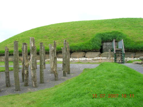
Figure 5.4 − The Arrangement of piles. Tumuli from Knowth group. Ireland. (A photo by Kskoba №6981088 from Panoramia).
In this detail one can see the connection of megaliths and one more variation of Late Neolith constructions − piled settlements.They used the same technologies, which were used by so-called marsh inhabitants, who used to build their dwellings on piles on low lake coast, and who disappeared just as suddenly and mysteriously as the builders of megaliths did. Such ending of both of these material cultures closely connected with water reservoirs once again points to the relief changes, which led to redistribution of the water on the surfaces of the Earth.
One of the largest constructions of this kind − tumulus-barrow Barnenez located on the northern coast of Brittany − is of special interest. It is established on a slope near the top of a height, perpendicularly to the coastal line, on the eastern coast of the gulf deeply shooting out into the land (Figure 5.5). One can get convinced of it after having looked at the figure … where the place of its locating is presented in larger-scale, and contours are drawn on the peninsula.
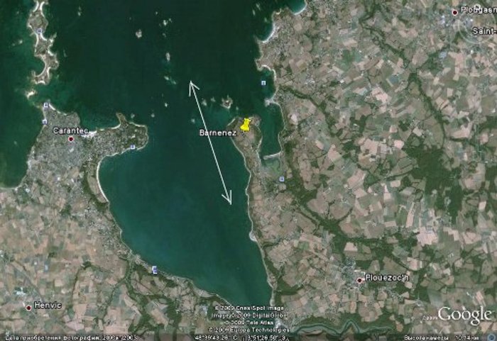
Figure 5.5 − Position of Barnenez tumulus in the gulf. An arrow shows the direction of the current along the coast.
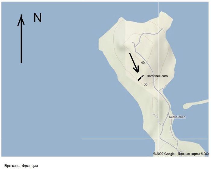
Figure 5.6 − Position of Barnenez within the limits of the peninsula.
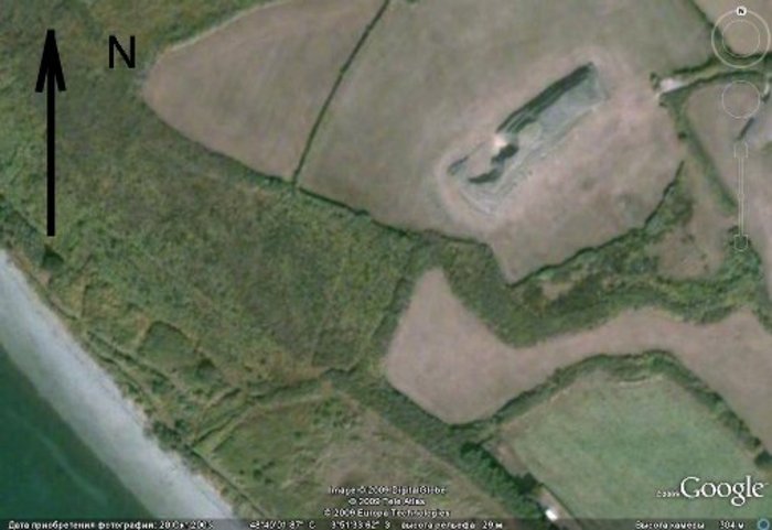
Figure 5.7 − Position of Barnenez within the limits of the peninsula.
As one can see in the pictures the construction is located as a usual barrow − from a watershed down the slope, across the coastal currents. In the same direction, compensating the immersing of the slope, the tumulus height increases. As usual, the dolmen’s exits, which fill it on SW as if it was an apartment building, face the Southeast, the Sun (see Figure 5.8).
This cairn has one more feature. Its eastern and western halves are constructed of different material. The first half (a darker one in the figure) was made of dolerite, which lays right here under the ground. The second half (a lighter one) was made of granites, which get uncovered nowadays only in 1-2 km to the north on a small island. Actually, these are two connected constructions, but the first one is considered older.
It is hard to believe that people having stones available at the place would deliver them from the island overcoming such distance aquatically or on the ground (the latter − if it was then connected to the main land). More likely, outcrops of similar granites were somewhere else, very close.
The matter is that the imperceptible growth of heights that was taking place then and is continuing now, must have gradually removed the first older barrow located at a higher level out of a zone of periodic flooding. It could not but decrease of efficiency of its work − to lead to reduction of the stagnant area behind it, and consequently reduce the amount of gathered floating plant residues coming along with water. The restoration of the former order demanded only to prolong the construction further into the sea. Quite possibly for the construction of this flank it became more convenient to take stones from a new place located somewhere near the modern coast from the seaside, in fact the coast was gradually shoaling. After reorganization of the relief, everything has changed. The depressions "fell" downwards, the heights "were squeezed out" upwards. The places of granite outcrops could get into a zone of depressions, to submerge under water and get covered by a thick layer of the deposits "disturbed" by the cataclysm. Who would think that just recently they could appear onto the surface and be the places of stone outcrops.
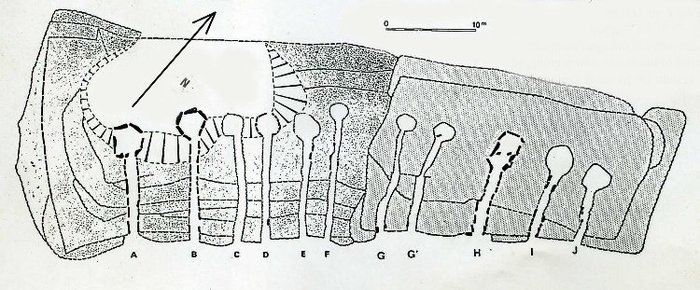
Figure 5.8 − Plan of Barnenez from “The megaliths of Brittany”.
In figure 5.9 one can see this majestic, similar to a fortress, construction. Pay attention, in the right part of the picture there is a border between granite and dolerite flanks.
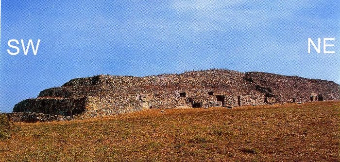
Figure 5.9 − General view of Barnenez. Photo J. − P. Gisserot from “The megaliths of Brittany”.
For the same reasons the barrow d’Er Vingle on the Locmariaquer peninsula was increased in the northern direction.
One more possible consequence of cairns’ existence in the conditions of periodic flooding are stone walls, which are sometimes located at some distance from them.
In figure 5.10 Kercado tumulus is presented. It is located near Carnac on a ridge between the depression 1 and 2. Pay attention, stones are located on the side to where the vegetative waste could float along depressions when they were flooded. In front or behind themselves they could retain waste, which floated on the water, or protect a tumulus wall from the waves.
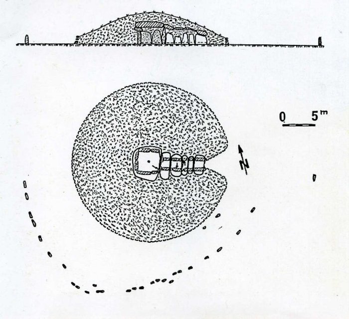
Figure 5.10 − Kercado tumulus. The stones are shown by black spots.
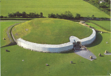
Figure 5.11 − Newgrange. A photo from a website www.ancient-wisdom.co.uk
In a similar way and from the same side the stones around Newgrange tumulus are arranged (Figure 5.11). Their difference is that they are of bigger size, and they stand farther from each other. In this position they could hardly retain anything on themselves but if they were used as supports for hanging something similar to modern camouflage networks, then it was quite possible that a shadow could be created behind them for accumulation of floating waste. By the way, something similar a net-like ornament can be found on some stones of this cairn.
A double range of vertically standing stones was revealed at the excavations from the sea end face of Mane Lud baraignment.
Take notice that Newgrange like Knowth tumuli is covered at the bottom by large stone blocks. It can be a reliable protection against the waves at the rising of water.
Nowadays it is difficult to imagine something less comfortable than a life inside a tumulus or a dolmen. However, the microclimate in them was almost the same as in caves. In summer it was cooler than outside and in winter is was warmer. The mass of stone smoothed the fluctuations of temperatures. There was one thing, in such small rooms without a pipe and ventilation it was impossible to make a fire. However, heating could be carried out in a different way.
In front of the entrance to Gavrinis and Table du Marichand tumuli at the excavation, there were thick layers of cloded ashes found. Probably, people made there fires and heated stones, which were then stacked at the entrance. A small rising of a corridor provided the distribution of warm air throughout the indide, up to the final chamber. A mat laid on stone floor plates made of dried floating waste could essentially improve comfort of such dwellings. However, it had to be renewed after each flooding, but nothing can be done without cost.
This is how people lived in those old days.
Menhirs
Menhirs are constructions which as well as all previous ones are mainly located on heights and sometimes accompany others megalithic constructions. In three cases known to me when menhirs are found in alignments (le Menec − once, Kermario − twice), they stand out of the general order by their position or size. This allows drawing a conclusion, that they had been established earlier. All the same, they more often stand as single construction. In our system of reasoning, they could be the very first landmark established by people when developing dewaterings. They could mark the places of natural accumulation of needed waste during the periods of flooding of plains when all other landmarks disappeared.
Stone steles are steady against the waves, do not decay with time, and are well visible depending on their sizes. Their establishment by a flattening along the meridian allowed people being roughly guided on cardinal points.
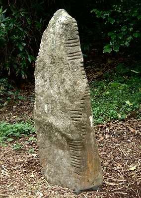
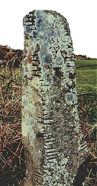
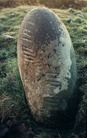
Searching the Internet I accidentally came across photos of the some menhirs in Ireland, which can have to do with a suggested hypothesis (Figure. 5.12).
The first impression is that these horizontal marks on the surface of stones show a changing level of water. With what periodicity were they made − each flooding, once a week, once a month or once a year − we do not know. However, if they were made, and, it seems, on a rather regular basis, most likely, the speed of changing the level during this period was not threatening for people.
However, quite possible, these notches designate something else. In Brittany where the same processes also had to take place, there is nothing similar to that. Moreover, fixing of such changes seems natural to a human nature.
Having agreed with menhirs’ location on dewaterings, the problem that for a long time troubled French researchers, that is searching an answer to a question concerning the vegetative cover in these territories in the past, is removed. Supposedly, the vegetative cover should not have prevented people from viewing menhirs and using them for astronomical predictions. In fact if one does not assume dewaterings here, then these places should have been covered by woods as they are nowadays, and there could be no possible sighting of the firmament with help of menhirs.
Now all becomes easier and clearer. It is not necessary to assume in these places moors or ferny brakes as the only vegetation in which menhirs could be visible. It is not necessary even mentally to make ancient farmers constantly for centuries destroy woods around of them. Or to put the responsible for absence of woods on hungry bretonian sheep who, in opinion of some researchers, ate up all brushwood, constraining this way an onset of plants.
For reconstruction of ancient landscapes around megaliths, one must use bulldozers and clear off all ground to the level of stones, sand, and clay. To remove all greens, all trees, and bushes, everything, down to grass and moss, and not allow them to grow again. The greater spaces such clearing captures, the more it will correspond to the way it used to be then. Ideally, it would be necessary to backfill bogs with sand and to level hills. Then we shall get something similar to what it used to be 4-5 thousand years ago.
| << Previous | Table of contents | Next >> |


