

To display the site correctly, please, enable JavaScript.
Appendix 2. Machu-Picchu
| << Previous | Contents | Next >> |
Some observations about Machu-Picchu
During our tour of Peru we managed to visit not only Nazca but some ancient sights in the Cuzco region as well. We did not have much time for every object, but I hope some our observations and conclusions will be interesting for our readers. In this chapter, I will discuss one more object, which I think has something in common with those that are listed in the chapter title, but which is situated far away in Africa, in Aswan. That is the ancient quarries where granite blocks were extracted and transported all over ancient Egypt.
Let us start with the world famous and mysterious city Machu-Picchu in Peru.The ancient city owes its name to the American pioneer archaeologist Hiram Bingham who named it after the highest peak in this area. He discovered these mysterious ruins in1911, during his expedition, the aim of which was to find the refuge where the last Inca hid himself from the Spanish Conquistadors. Bingham wrote about it in his book “Lost city of the Incas", unfortunately, the book was not published in Russia yet.
Here are some physical features of Machu-Picchu. The city is situated in the eastern part of the Andes, at the border of the area where the Amazon lowlands influence the climate. Tropical vegetation is already developed here. The city is located at an altitude of 2800 m, 400-450 m higher than the Urumbamby river, which flows at the foot of the mountain.
The position of the city is one of the most remarkable and puzzling things. It is located on a small and seemingly impregnable saddle between two mountains bounded by 400 m cliff from the south-west and a slope covered with dense thickets from the northeast. The view of the city from the top surrounded by deep and lost in shadows Urumbamby valley against the background of dizzying peaks of the surrounding mountains makes a fantastic and unforgettable impression. The extraordinary location of the place makes you think about its special purpose (Figure 1).
However, even Machu-Picchu is not the apotheosis of absurdity. A few hundred meters away from it and 200 m higher, at the very top of the neighboring peak Wayna-Picchu another similar settlement is located. Going along a narrow razor-like watershed, you can get to almost vertical stone steps above the abyss. Using the steps you can reach a small piece of ground where similar stone houses with gables are, and cascades of terraces cling to steep cliffs.
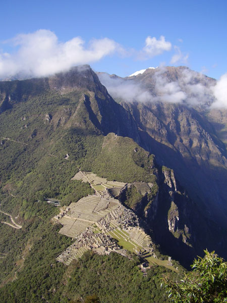
Figure 1. Foreground plan – the city Machu-Picchu, view from Wayna-Picchu. The dark mountain with the cloud in the upper left part is Machu-Picchu. The photo № 4868899 (here and subsequently, the number is taken from the Panoramio site, unless another one is mentioned).
Another remarkable feature about Machu-Picchu is the fact that the buildings there were made of stone blocks laid on top of each other in a way that between them there are virtually no gaps. Often it is impossible to stick even a piece of paper between the blocks. Despite the apparent complexity of fitting blocks together in this incredible way, this phenomenon is not unique in Peru. Such masonry can be seen in Peru, Kuzco and in many ancient ruins in the Urumbamby valley.
The technology, which permitted such accuracy in the fitting of the blocks, though they are made of granite, which is characterized by extreme hardness, is still a mystery to researches. Even now with all diamond tools, electric and pneumatic equipment on such a massive scale, it is not feasible to fulfill this work with such consistently high quality. I tell about this not as a geologist, but as a specialist in stone processing.
We came to the museum in the morning and walked around until evening, when we were asked to leave the museum. We went up and down along the steps looking at the objects from different points and examining the samples of famous seamless and normal Incan masonry. We also studied the location of blocks, scattered over the surface, analyzed the morphology of rocky outcrops with traces of processing or without them, and marked the signs of new tectonics. In addition, of course, we took photographs of everything that somehow attracted our attention.
Naturally, I was most of all interested in the details pointing to the recent restructuring of the relief, with which I associate the main features of the structure and development of the territory. Their presence manifested itself in the characteristic relief plan. Mountain ridges formed a system of fronts framing a center. The objectivity of their existence and the dynamic nature were confirmed by asymmetrical profile. As usual, the front slope is steeper, and the rear is flatter. In fact, it was the same deformation structure as in Nazca, only on a bigger scale. One of them was a ridge, on the saddle of which Machu –Picchu lies.
Figure 2. The dynamic scheme of Machu-Picchu area.
Like most of the structures in this area, on this site it had steeper south-west slope and flatter northeast slope. It indicated that the main force here acted from the northeast to south-west, and the center of its application was somewhere at Aguas Calientes. I think that recent striking evidence of geological anomaly of this place are the thermal springs, which gave the name to the settlement (Aguas Calientes means hot springs). Smaller structures in the form of rocky cliffs of typical shape eloquently pointing to lateral compression we already saw in Machu-Picchu. The most striking example of it is the base of so-called “Condor Temple”.
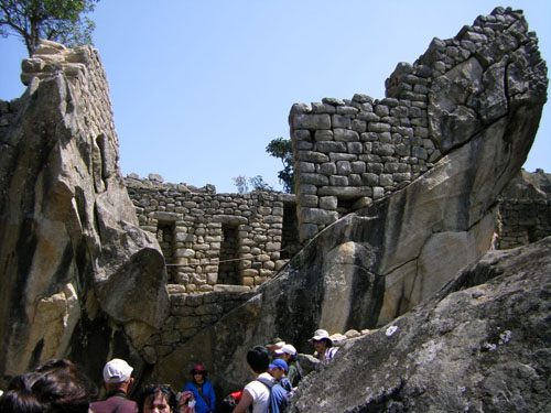
Figure 3. Tectonic scales in the base of so-called “Condor Temple”.
A block, which looks like a shark chasing the prey, jumped up half of its length and froze (Figure 3). It may even seem that it moved together with the construction, but no, it was built later.
Similar pattern we can see at “The Temple of the Sun”. We can say, “so called” with any object here, because nobody really knows neither the purpose of this structure nor the name of it. This is conventionality based on some external features and coming out of the concept that such unusual city like Machu-Picchu could not be anything else other than the ritual center filled with temples.The foundation of "The Temple of the Sun" also moved onto the underlying block and got pushed up (Figure 4).
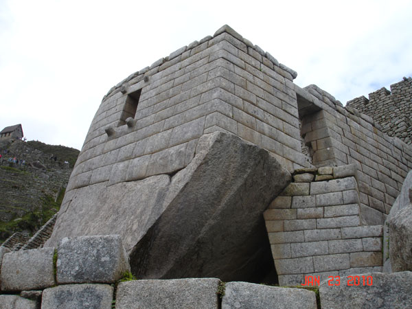
Figure 4. dsc04941 Temple of the Sun.
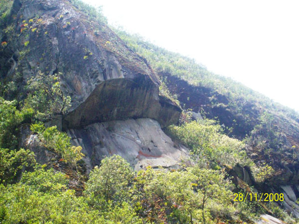
Figure 5. №21242773 Shift of the rock on the slope.
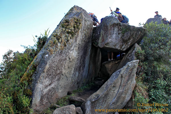
Figure 6. №56587116 Huayna Picchu.
Similar structures are shown in Figures 5 and 6. In the first figure pressure from the side ended with the creation of a hanging cliff, in the second one we see the end of tectonic scales smashed by a fallen block. According to clean surface of rocks and lack of degradation products, soil and vegetation on them, we can see that all shifts are quite recent. The vertical slopes from the south-west have the same “fresh” appearance. The impression was that they got uncovered just recently.
The ruins of stone blocks on the museum territory also attracted my attention. One of them was on the south-west part of the territory (Figure 7), another one framed the city territory from the east. Huge separate blocks lay on the northeast slope of the mountain.
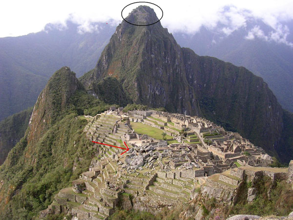
Figure 7. Red arrow points at the blocky ruins, the black oval points at the settlement on the top of Huayna Picchu.
The existence of blocks on the watershed excluding the possibility of their having fallen from somewhere above, scattering, sizes, and sharp shape inclined us to think, that it was not a result of erosion but required a hard tectonics involvement. Only a powerful blow from below could explain the character of these ruins marked with the arrow. As a result, the masses of rocks forming the surface were smashed and thrown up. Falling down they created the chaos, which we can see now (Figure 8).
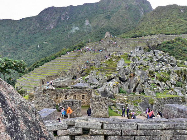
Figure 8. Blocky ruins at Machu-Picchu.
The ruins in the north-west part of the city were created probably in the same way. Later the fallen blocks were used for building of agricultural terraces.
All these catastrophes took place before people came here. However, the belt of ruins framing the city from the east appeared later. Most likely, it is a tectonic zone upon which the shifting of the surface was taking place, one of those, along which the formation of mountains occurred. As a result, structures located near it were ruined.Hiram Bingham noticed the strange thing in the process of excavations - an unusually strong and hollow sound when working with a hammer and an abundance of empty cavities inside granites. The workers dug out such places enthusiastically hoping to discover treasures. They thought that ancient builders made these empty spaces inside granite, but they worked in vain. The spaces between gigantic blocks were empty.
In my opinion, this is another sign of distinctive “loosening” of the upper granite layer, caused by powerful tectonic shifts and earthquakes. Under pushes and blows blocks moved from each other creating cracks, partly filled with stone debris.
Seeing fresh traces that witness, in my opinion, to lateral pressure, I decided to see if there were any recent flows of magma material in Machu-Picchu. If there was a residue of magma not too deep, it is logical to suppose that under pressure it would seek an outlet upwards.
Besides, I concluded, like many others, that liquid magma was there because of the same “seamless masonry”. Thinking abstractly, the blocks, out of which the walls were built, most of all resemble molded metal. Some of them formed the corner elements of the masonry at the joining walls (Figure 9), others had 10-12 cut sides and they were laid so close to each other that I cannot imagine how it could be achieved by ordinary means, - the blocks weighed so much that it was impossible to place them in position for a trial. There were also sometimes signs of molding on the blocks (Figure 10).
It seemed, though, it was possible to reach such ideal joining of the elements of the walls only by molding. Although in that case, it is difficult to understand why they used blocks, it would have been easier to build the walls by pouring layers as we pour concrete today.
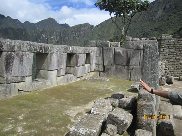
Figure 9. In the center of the photo there is a block forming an angle.
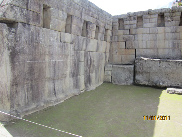
Figure 10. At the left, there are signs left after pressure of the mold on the big block surface.
However, there were no traces of volcanism, no ash, no tuffs, no lava cover either in Machu-Picchu, or in surrounding area. Everywhere, in the outcrops, in debris, and in the walls, the granite was light, clean and ordinary, and rarely pieces of grey shale. This made me doubt this version. I have never encountered the outpouring of granite onto the surface.
Volcanic (erupting onto the surface) rocks of the same chemical composition as granite are found in the world. They are called “liparit”, but they are always less capable of crystallization. It is because they come to the surface in melted form and their rapid cooling on contact with the air does not allow mineral crystals to form. That is why liparites consists mainly of glassy mass. Very popular in Stone Age obsidian – so called volcanic glass – is a type of liparit. However, I could not allow that non-crystallized granite could be squeezed onto the surface from the depth.
I was leaving Machu-Picchu with a sense of dashed hopes. Some of what I saw was encouraging, but the pieces did not fit together. Our last hope was Ollantaytambo and Sacsayhuaman, where we could probably get some hints.
At home, I wondered whether, in principle, the flow of granite, while maintaining its full-crystalline structure, is possible. Alternatively, maybe, taking into consideration the density of such crystallized magma, its appearance on the surface will look more like cream squeezed out of a syringe, rather than outpouring. Perhaps, it may be possible, if we assume there remains at least a small fraction of melted substance enveloping and linking the crystals. This fraction may be the first small part, but if this melted substance is there, then the whole mess of crystals can flow slowly. Earthquakes, pressure build-up, and vibration should accelerate this movement, while cooling will slow it down. The closest analogy is the sand at the water's edge. It is saturated with water, but it is solid and it is difficult to thrust a stick in. This is because the waves have tightly packed all the grains of sand against each other and water takes up only a small space left between them. However, as soon as you make the sand vibrate, it liquefies, and your stick or foot easily begins to sink into it. If you stop the vibration, the sand "freezes" again. Water in the sand, despite its small amount, acts as a medium giving the entire mixture under certain conditions rheological (liquid) properties.
Unfortunately, it is impossible to conduct experiments to establish the fluidity of these or other granites returning them to their original state by simply heating and melting. The fact is that the foundation of granite - the minerals quartz and feldspar melt at temperatures of 1700 and 1300 degrees respectively. This is more than the melting point of the hottest basalt lava. It means that in order to melt them you will need temperatures of at least 1300-1400 degrees, then the quartz can begin to dissolve in the melting feldspar. Nevertheless, geologists believe that the granite magma is one of the “coldest”; according to some data, its melting temperature is about 800º C. The difference between melting temperature of the granite and the natural melted granite is due to the presence of considerable amount of water in the latter, which lowers the melting point of the mixture. Out on the surface the water evaporates, the granite "dries", and in this state, it is very difficult to melt it. However, there is no need, because by exploring its parameters we do not get an idea of its primary state.
Therefore, I decided to admit the possibility of the flow of granite on the surface, but not as liquid mass, but in the form of a very thick mushy mixture. Now all what I needed to understand was how the places of granite outflow could look on the ground. If they were outside of Machu-Picchu, I would have missed them precisely because I did not inspect the vicinity, and if they were in the city - what could they be? Even when looking at Machu-Picchu in photographs I noticed strange single not very large but well maintained granite ledges on the floor within or near some constructions. Usually they occupied a central position on the ground and sometimes were surrounded by stones.
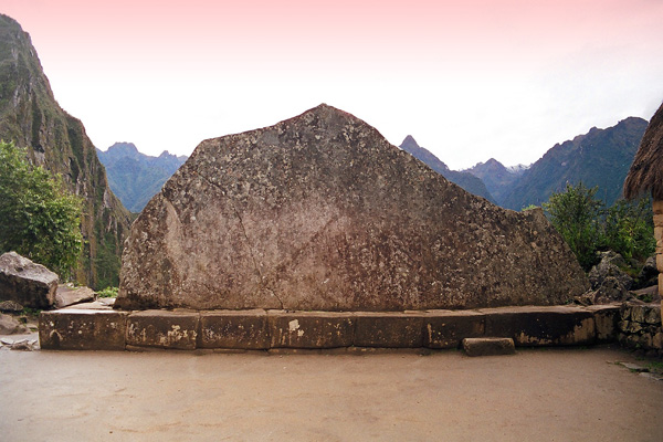
Figure 11. Panoramio 10273.
Some of them had a strange shape - combinations of differently oriented planes. These included the famous Intihuatana presented in Figure 12 and Figure 13. Guides attributed religious or sacred purpose to such stones. Intihuatana, for example, appears as the main stone, which is tied to the Sun. That is, neither more nor less, this ledge was presented to be the center of the world!
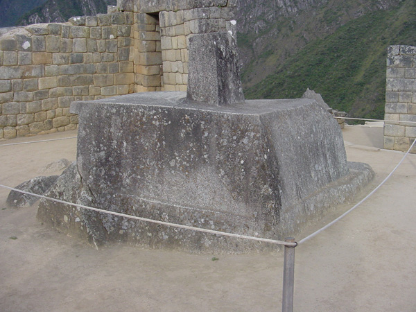
Figure 12. №73220. Intihuatana.
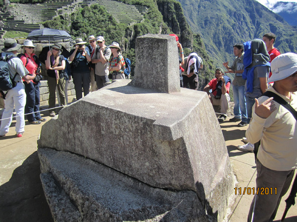
Figure 13. Intihuatana (author’s photo).
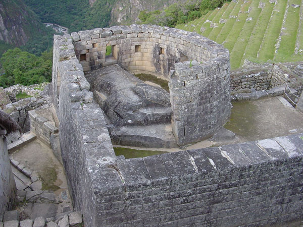
Figure 14. № 73219. Granite ledge in the floor of the so-called “Temple of the Sun”.
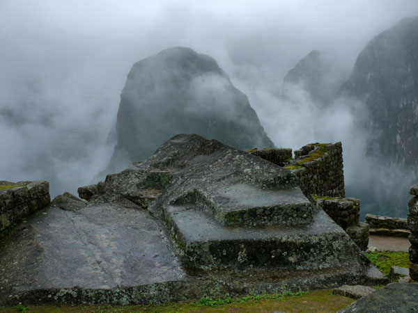
Figure 15. №48175765.
Figure 16. № 10519375.
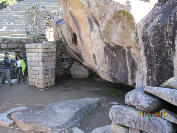
Figure 17. Granite ledge at “The Condor Temple”.
When I heard about sacredness, my first reaction was that this is a riddle, something incomprehensible. Saltykov-Shchedrin wrote, "if they start talking about patriotism – it means that they were caught stealing". Here is was something similar: they talk about sacral meaning – it means they do not want to admit their lack of understanding. Nevertheless, the mere presence of these ledges was clearly not accidental. In the city of such skilled stonemasons, these ledges would be removed immediately if they interfered. However, as they were kept safe, it means there was some reason for that.
On my return home, I took the Bingham's book. There was a lot of interesting information about the organization of expedition, its aims and history of Inca resistance to Spanish conquistadors, but the description of excavation started only in chapter 9.
Here I noticed something very interesting information. Bingham, clearing "The Temple of the Sun" (Figure 4, Figure 14), which he called so for a magnificent masonry and a form similar of the Temple of the Sun in Cuzco, noted that granite walls inside the temple experienced powerful temperature impact. He made such a conclusion, because of a characteristic shell form of cleavages, which are visible on a swell-like ledge of granite on the floor and numerous cracks in blocks of granite walls. We will add that from the inside the granite rusted (Fe+2 when roasting passed into Fe+3). Heat was so strong that even window boarding joists burst. Bingham assumes that it could be a place of sacrificial burnings. At the same time, he writes that inside the temple, there was neither coal, nor ash traces, meaning that the fire in the temple could occur long ago and its traces could be cleaned. This is difficult to disagree with. The room could be swept and cleaned thousands of time over the centuries. Nevertheless, my first thought was that the temperature was caused not by sacrificial fires, but by deep (endogenous) heat in a place of granite outflow. Hence, the creation of a wall around this place was caused not by worship of the Sun, but by the desire to contain this source, and to have an opportunity to take the granite, which has not hardened yet.
However, why then all the internal granite blocks were cracked so much after all? The sub current of heat could not be strong and could not cause fast overheating of the surface with the subsequent flaking of stones.
Considering different options, I returned to the idea that the cracks resembled the influence of a big fire or that was a result of a sharp cooling of the warmed stone by water. Let us try to understand it. Luckily, we managed to find a good photo of the Temple in the Internet.
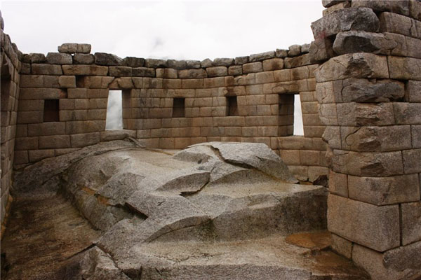
Figure 18. Interior of the Temple of the Sun (No. a64d1374b5ee).
First, pay attention to a swell-like form of the granite ledge in the center. If my assumption is right, and the granite mass was really squeezed out, this form corresponds well to such process. The step in the foreground, similar to that we saw earlier, and the planes at its top testify that some blocks could be separated from this granite. Even more indicative is existence of the seam separating the left side of the ledge. It is presented by a close up in Figure 19. You can see that the containing granites, also partially involved in this movement, and their edge contacting with plastic mass have risen.
It is interesting that this swell reaching almost up to the window inside, did not express itself in any way outside. From this, we can conclude that the channel of magma intake was all localized in the so-called temple. Now the base of this building is a cliff, which is open from three sides and has been cut off by slanting deformation (Figure 4). Is it possible that such base of the Temple was capable to pass hot granite mass through itself? Is not this section too small in order to provide the necessary sub current of heat to keep the magma in a “plastic” state? I believe, the answer is not in favor of such possibility. Then, how did the granite reach the Temple? The answer to this question may lie in the fact that the ledge appeared later, and after its appearance, the flow of granite gradually stopped. In a modern state, it would radiate heat into to space much more than before its appearing. It means that at some point the plug made stiffened granite could be formed inside.
What actions could be undertaken to try to resolve this critical situation. The first thingthat comes to my mind is thatit would be necessary to warm up a source and try to break a crust of the stiffened granite. The simplest thing was to start a big fire inside and afterwards to pour water over the granite. If the process of cooling did not go too far and plastic masses were nearby, then probably they could be opened. This is when the fire could be ignited inside the temple, from which the walls cracked.
However, most likely, these hopes did not come true and the plug was too big. The factory of "baking" granite blocks (as a blast furnace) stopped working and was abandoned). The same thing happened to all other granite sources for one reason or another. The changing of a relief was ending, high mountains were formed which uplifted the City to the modern height and made it inaccessible. Inside the mountains, it became more difficult for granite masses to move ahead. The path became longer and temperature fell due to heat return by the already formed slopes. Today instead of granite flows, we witness only thermal waters in Aguas Calientes near Machu-Picchu. By the way, this place is exactly the center of the dynamic structure shown in Figure 2.
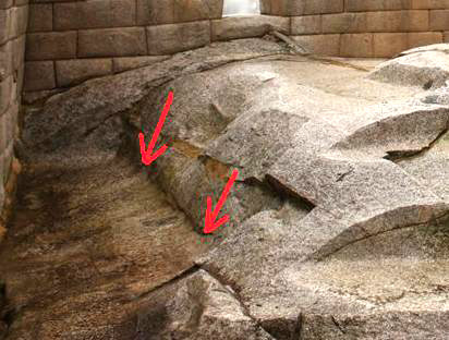
Figure 19.
This development is confirmed by the nature of the evolution of masonry, both at Machu-Picchu and around the region. Older masonry is always more perfect than newer one. Fans of the “golden age” associate this with the degradation of humanity. Lower parts of many of the structures are made in the impeccable technique of seamless masonry (Type 1). Above there are rows of more or less rectangular blocks with significant seams (Type 2). However, the majority of structures are built of ordinary stones of irregular shape with large seams filled with clay solution or clay-rubble filling inside the wall (Incan masonry - Type 3). Some examples are shown below.
The first picture (Figure 20) shows seamless classic masonry and a bit of the second and third type masonry. Please note: blocks in seamless masonry can be very large, but such blocks form only lower rows, the size of the blocks decreases with the height. Seamless masonry has three varieties: laying of multiangular blocks (Figure 21), masonry of regular rectangular blocks (for example, the Temple of the Sun), and masonry with sand and clay filling of the space between outer and inner layers of walls, made of blocks without seams. A hardly noticible feature of this masonry is the presence of traces left after contacting with neighboring blocks. The depth of the traces is typically less than 1-2 mm, but they are there, and this is the most important argument in favor of maintaining of the view that stones had certain plasticity for quite a long time even after setting them in place. A little later we will consider how people separated blocks from the source.
In the top part of the fronton one can observe transition to the second and the third type masonry. Immediately above seamless masonry we see more or less rectangular blocks, and above them we see blocks of different shapes and sizes. They are the smallest in the entire wall. In accordance with our logic, masonry of the second type can correspond with the final period of granite mass efflux. It was not too hot, and its ammount was reducing. It became more difficult to separated the blocks, their plasticity was close to zero, but it was still possible to split granite, because it did not obtain its maximum hardness yet.
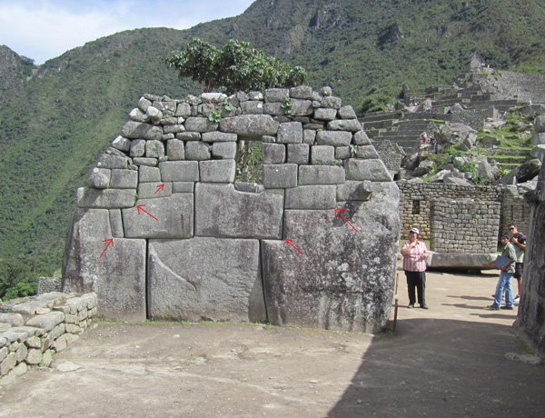
Figure 20. Example of masonry of the first, second and third types.
The very top of the fronton corresponds with the "cold" period, when good life for the masons ended. Granite mass fully hardened, it became very difficult to handle stones, and now people simply used available stones around matching sizes and shapes to provide a more or less tight laying.
In Figure 21, we can see the same order again. The lower part of the wall has a great quality seamless masonry, the upper part has the masonry of Type 2. Blocks are almost right parallelepipeds, but there are already seams between them.
Figure 22 shows the masonry of the third type. Like in the previous case, it finishes the construction. Stones used here can not be called blocks. They have tabular form. Seams are filled with mud and have a thickness almost like in conventional masonry. In Ollantaytambo such homes are often plastered outside and inside and resemble modern buildings that are worn out.
In Figure 20 and Figure 22 you can see that in both seamless and the third type masonry there are similar stone cylindrical elements for fastening of the roof. The same applies to the niches that continue to be present in traditional form in later buildings with the third type masonry. Compliance to the geometry of buildings as a whole still remains at a high level. All this tells about preserving traditions and does not allow suggesting that the work was continued by people from another civilization, by some barbarians. The work was done by the same master or their heirs, but in a changed environment.
Somewhat surprising is sharpness with which these changes occurred and the scale of construction. It seems that many facilities were built at the same time using the method of seamless masonry, then at some point the best building material ended and the builders had to use second and third best material in order to finish their projects.
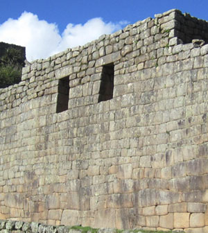
Figure 21.Upper part. The masonry of the second type.
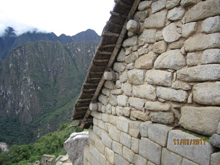
Figure 22. Fronton. The masonry of the third type.
Similar evolution in masonry can be observed in Ollantaytambo and Cuzco, which indicates that the process of therelief formation and outcropping of plastic masses took place not only in Machu-Picchu.
Tectonic activation was over; the relief, which had formed in the process, stayed, and different plastic substances (by the way, not necessarily hot) simultaneously squeezed out from the depths eventually hardened. Some “froze”, others went through the process of recrystallization (as limestone on Malta) adapting to new surface conditions. Example of the latter are the masses of limestone that outcrop in the area of Sacsayhuaman, from which material was selected for making of wall blocks for this so-called “fortress”.
The question may arise, why there was no normal volcanic outpourings, such as basalts, which would have laid on cultural deposits and thereby showed that recently some very unusual events and processes took place. The answer to this might be the following: first, perhaps, they were (the region has not been studied very well yet), and second, the Andes in the recent past were the area of downwarping (geosyncline) filled with a thick mass of sediments, which would make it very difficult for basalts to get through. In their movement to the surface they could absorbe surrounding material and begin to change and evolve into something else, for example, into andesites and dacites. We find these rocks in blocks of Tiwanaku and Sacsayhuaman, across which they form a wonderful hill. It is composed of lava formations and resembles cream squeezed out of a culinary syringe. Flows of andesidacite, this is the accurately name of this rock, preserved the profile of cracks in their form. It was along these cracks that they were squeezed out forming a gorgeous shiny crust of glassy glaze, which they were covered by as a result of sharp cooling on the surface. Now children and adults slide from these hills, as if they were icy, not knowing that recently it used to be the mouth of a small, but perfectly “real” volcano with red-hot lava, earthquakes, and eruptive outpourings, that is testified by giant blocks of calcareous rocks scattered on the surface and by a small caldera.
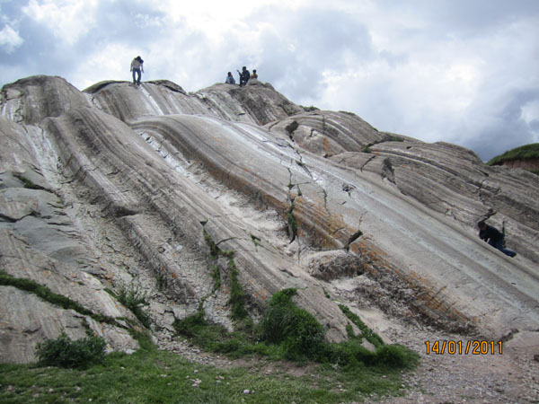
Figure 23. Lava extrusions opposite Sacsayhuaman.
After visiting Machu-Picchu we stayed for a couple of days in Ollantaytambo. Here, too, was abundance of seamless masonry, only more sophisticated − blocks with 5-6-8 sides were connected to each other. It seemed like ancient stonemasons were laughing at us connecting minute projections and steps, as one can see in the figure below (Figure 24). It can not be, − our mind resisted, − but our eyes convinced of the opposite.
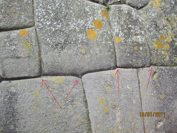
Figure 24. Blocks in Ollantaytambo.
Here we repeatedly saw quartz or carbonate veins in blocks, which indicated that the material did not represent structureless plastic mass. Here we also came across with an interesting feature of some blocks − they had some projections of unknown origin. They were located on the front surface and almost always in the bottom half (Figure 25). Small blocks (approximately 100 kg) had no such projections. However, projections on giant blocks weighing tens of tons, − if they were there − looked differently and were located in different places (Figure 26, Figure 27).
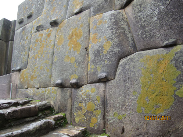
Figure 25. Projections on blocks in Ollantaytambo.
Their presence was puzzling: the first thing that occurred to me was that they had some technological explanation. Perhaps, they were needed for the installation of blocks. But then why they were not removed afterwards. The costs seem minimal compared to the cost of processing of unthinkably accurate meeting sides. Besides, these projections lowered the degree of security of the walls, if we assume that the latter were built to defend against enemy. Finally, they did not add any beauty either.
The nature of the sides’ relief of one more Temple of the Sun in Ollantaytambo was even stranger. Almost all blocks had massive projections on one of the sides. The largest one located on the second block on the left bore traces of something like wind erosion or dissolution. On all sides it was framed with shell-like surfaces. It looked like as if something was carving it from the sides. Projections on the far right block were less expressive, but essentially the same. Stepped relief on the central block was amazing. It was so low-contrast that in the scattered light it was almost invisible. This could point to its technological origin. Furthermore, some smudgy horizontal stripes could be seen on all blocks.
When looking at all of this the same questions rose. Was it so difficult to remove these projections that had clearly technological nature? Compared to cutting blocks out of the solid mass, delivering them to the site, lifting them onto the mountain and installing into the wall with gaps smaller than the thickness of a match, the cost of the removal of the projections seems really insignificant. Why the aesthetic sense of the ancient builders went to sleep at this point? May be, they were just too lazy or something prevented it? By the way, as usual for megaliths, there are no traces on the blocks that would let us understand how they were separated from the solid mass!
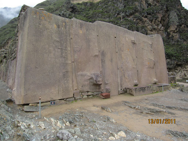
Figure 26. Building blocks of the Temple of the Sun at Ollantaytambo in cloudy weather (the author’s photo).
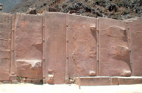
Figure 27. Sculpture of the surfaces of the blocks of so-called Temple of the Sun. (Frafment of the photo from Panoramio № 2354108). The sun has passed its zenith.
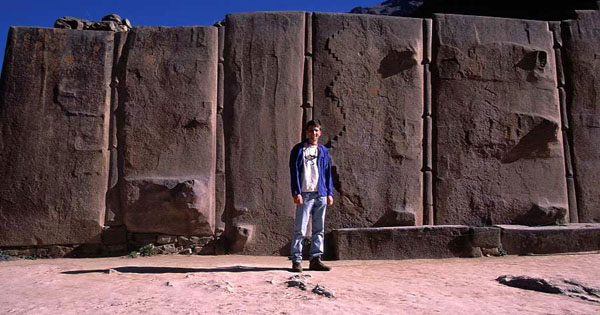
Figure 28. Wall blocks of the Temple of the Sun. The Sun is in the east. From site atsibudimas.ucoz.com
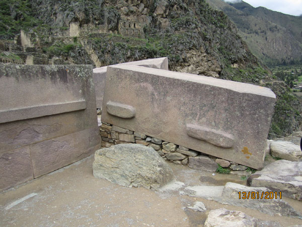
Figure 29. Blocks with projections and flaking of the surface (left).
Of course, I wondered what material these blocks were made of. Chipping a piece would be barbarism, but luckily we managed to find a few small fallen plates underneath − the surface of the stone was flaking in some places. The stone had reddish color and contained bright inclusions.
Another interesting finding was waiting for us on the road under the slope of the spur, on the top of which the Temple of the Sun was set. At the side of the road there were a couple of blocks of the same reddish stone, which were abandoned for some reason. One block weighed about 5 tons, and the other one weighed40-45 tons. On their sides we could not see any holes or cracks through which the builders could break it off from the array. The surface of the blocks was straight, but rough, showing the grain structure of the stone. I did not understand if it was a natural stone chipping or the result of processing.
The upper surface of the large block was especially interesting. First, it had a chain of double dimples repeating about every half a meter. It looked like it was pressed against an uneven log that could be used as a roller to transport the stone to the installation site. Second, on the surface of the stone there were many overlapping round dents reminding the surface of the monument in the ancient quarry in Aswan (we will discuss it a little later).
Existence of the chain of paired dents fit into the proposed "hot" version of the rock excavation.
Analysis of the material in St. Petersburg showed that giant blocks from the Temple of the Sun were made of rhyodacite (or granite-porphyry). This rock consists by 50-60%of rounded crystals of various feldspar and quartz embedded in microcrystalline mass. The presence of this mass indicates that the rock could have volcanic origin and could be squeezed somewhere onto the surface. It did not flow, but was squeezed because silicic magmas (magma with high SiO2, to which this porphyrite belongs) are characterized by high viscosity. While separating such block from the array that was still hot dents could be formed due to the rollers put under it.
Overlapping shallow dimples also fit into this "hot" version. We will consider a little later how they could appear and how blocks were separated from the array.
But now we will move thousands of kilometers to the east, to Africa, to the ancient Egyptian city of Aswan.
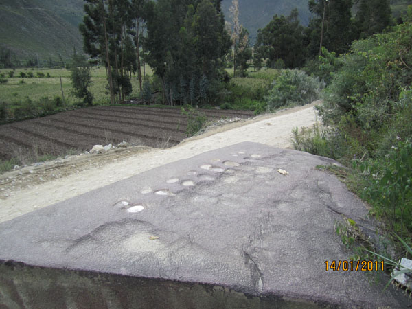
Figure 30. Egypt
Egypt
I visited Aswan in 2008, but at that time I did not know about ancient quarries, so I took no action to visit them. The first acquaintance with this remarkable object took place by means of photographs that I happened to find in the Internet and, of course, they did not leave me indifferent, although the questions that they provoked in me were first formulated a few years earlier... In 2004, when visiting the Pyramids of Giza, on the granite facing of the pyramid of Menkaure I noticed strange projections, as if made for the convenience of lifting blocks by hand (Figure 31). The surface of the blocks was also unusual. It was rounded and resembled the surface of a boulder, although it was not such.
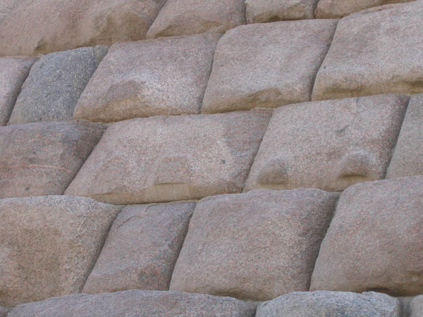
Figure 31. Granite facing of the pyramid of Menkaure.
By that time I had been studying stone processing for more than 10 years, and such nature of stone surface reminded me the processing of stone by fire. Blocks had rounded corners imparting the product a cushion-like shape. Corners are the first parts to break off when exposed to flame. There were no traces of chisel, but one could clearly see some thin surface flakes. Overall surface roughness is also typical of fire-processing method, revealing the size of grains that constitute the rock. But at the same time, there were projections on some stones that should not have been preserved if the surface of the blocks had been processed by flame (for example, in the campfire). Naturally, I could not allow that the ancient people had equipment similar to a modern burner, by means of which it is possible to create more subtle relief on the stone surface. This method of stone processing is called a fiery method. It uses so-called “thermal baffle plate” − a device that in a way reminds an engine of a supersonic jet aircraft in miniature. Flame that is emitted from such burner differs from jet flame out of the blast pipe of the plane only by its scale. There is the same roar and the same cross banding of jet flame. I could not allow the possibility of creating something similar by the ancient people, so I started to figure different uses of fire, coals, or bellows. As I did not come to any convincing solutions and could not explain the presence of the projections, I decided to put aside this problem until better times. Now, it seems, these times have arrived.
After our trip to Machu-Picchu and Ollantaytambo and receiving some evidence that during the period of the activation of the reorganization of the relief there could exist small sources of partially molten masses of igneous rocks on the surface a solution to the riddle of the form ofthe blocks of Menkaure pyramid could be approached from a new angle.
While working on this article, I have repeatedly returned to the pictures of granite quarries in Aswan. The main problem for me was presented by so-called Monument. Its picture is shown below (Figure 32, Figure 33, Figure 34).
In order to give some idea of the scope of this obelisk I am going to list its dimensions: its length is more than 40 m, and its section is 4x4 m. Such workpiece would weigh about 1500-1700 tons. It is clear that even by modern standards the work of extracting and transporting this monolith had all chances to be listed in the Guinness Book of Records.
However, the uniqueness of the obelisk was not limited to its sizes. Unusually strange were the traces of
technology by means of which people destroyed the stone in order to separate the unit from the array.
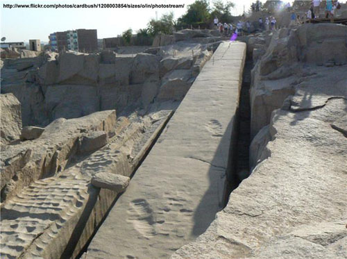
Figure 32. Workpiece for the monument. Ancient quarries of Aswan. Fragment from Panoramio photo № f337b353e97f.
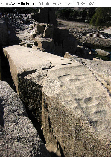
Figure 33. The top of the monument. Photo № 6f8f60b0af48.
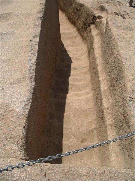
Figure 34. Bypass trench. Photo № 27e87799bafft.
A would be stele was first outlined by a trench. Then, apparently, the builders were planning to cut it from the bottom. Following pictures will give an idea as to how they were going to do this (Figure 35, Figure 36).
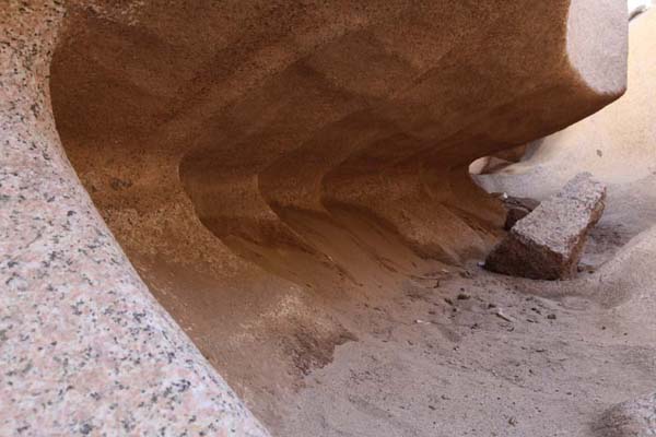
Figure 35. Cutting of the block from underneath. Copyright?
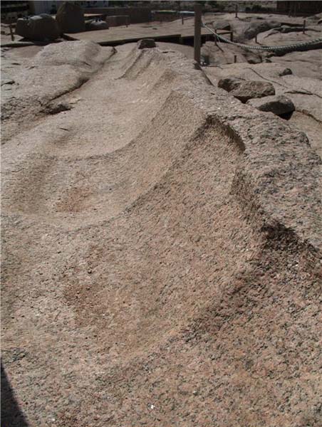
Figure 36. A “leg” remaining after the separation of the block. Photo № 6cc5b0421act.
We were surprised not only by the extent of preparatory mining works, as if it was not granite, but some wet sand or clay. Above all, we were impressed by technology or method, by which the ancient people destroyed stone. Instead of traces of tools on the walls of the trench and on the monument itself and around it there was some strange microrelief vaguely resembling water ripples. Series of shallow dimples were separated from each other by not high, but by quite clearly manifested ridges. Something similar could be created by a thermal baffle plate, but how could it be there? Besides the burner, not the simplest device to make, one would need diesel fuel and gasoline as well as a compressor with hoses capable of keeping pressure of about 10 atmospheres.
What if, I thought, here in Aswan granite was warmed up as well, because it was the same time − Prehistoric and Reconstructional. What if the quarry was laid at the place where heated granite masses were being squeezed onto the day surface. After all, the career is located on the hill, this place really stands out in the relief of the town.
If so, then the ancient people could come up with a simple and affordable technology of destruction and processing of stone. This could be done by the means of... water. No, not by high-pressure jets, which are used nowadays to cut stone and metal, or oxyhydrogen torch that uses water from an electrolytic device. They could water, the most common water, without any tricks.
Destruction of granite by a thermal baffle plate is based on a sharp heating of the surface layer (thermal shock). Under the influence of a powerful jet of hot gases escaping from the burner the surface material heats up and expands. Then it breaks off from the foundations that is still cold in forms of plates and scales. Destroyed stone is immediately blown away exposing new surface ready for the next thermal shock. In its present form the method is very productive, although it is used only for rough processing of stone. However, the main thing here is not the heat, as it may seem at first glance, but the temperature difference between the surface layer and the foundation. It is this difference that generates tension in stone that destroys it. The same process is going on in nature constantly but slowly, when stone is heated in the sun and cools down at night.
But what if stone is already heated up? Maybe, you can do the reverse, that is, to apply a “cold shock”, to destroy granite not due to its expansion, but due toitscompression. It is unlikely that they had liquid nitrogen in Egypt in those days, but there was enough water. If you splash it on heated surface of the stone, then it will begin to break down at that spot forming shell-like fragments. Then, you will have to remove debris, wait for the temperature to recover and repeat the operation all over again.
Look at Figure 32. On the monument itself and on the surfaces around we see rows of square cells with concave bottoms. In some pictures we can even see the traces of water that stayed there, probably left from pouring. This led me to believe that those cells did not appear accidentally during the stone processing or due to cyclical movements of the hand of the worker, for example. They were created specifically, which is indicated by the order in their arrangement, and they were that basic device, by which people broke the stone. This is how it could be:
A square pattern was drawn on the surface that had to be flattened or lowered. Then, in the center of each square the builders began splashing water. It started boiling and the stone in this place started to flake and peel off gradually forming a small hole. When all the holes were formed and the whole work surface was covered by them, they simply poured water into them. Next, the water started boiling and did its job. The bottoms of these granite “pans” flaked and the destruction process gradually went down. People only had to maintain the geometry of the cells by controlling the process of pouring of water into them, and each time after its evaporation they had to remove the products of rock destruction. As this process moved in depth, on the walls of the trench being formed vertical traces were preserved. They corresponded to the cell boundaries. If you look closely, you can see horizontal shading that was preserved as well from the traces of the water processing cycles (Figure 37). Pouring water into individual cells with certain frequency people could even create a rough relief, in particular, inclined surfaces. This is what took place during the formation of the pyramidal top of the monument.
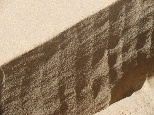
Figure 37. Traces of cells on vertical walls and horizontal shading of individual cycles.
It was somewhat more difficult to use this method to cuta stone block from the bottom in order to separate it from the array. In this case, the process of destruction had to be directed to the side, not downwards. It was not possible to pour water under the block. This could be achieved by spraying of water in a certain direction. However, in any case, water flowed down and the process of forming of the bottom niche was accompanied by deepening the trench that framed the block.
If the same spot was exposured to water for a long time, the destruction process could slow down because the spot would get colder. In this case it was necessary to pause until the temperature is restored from the heat coming from below, then it was possible to continue processing. In order to process the stone in this way as long as possible one had to try to save the relationship with the array for the longest time, thereby providing heat influx. So, it was reasonable to cut the stone from underneath only after all other planned works were completed, including, perhaps, even drawing of hieroglyphs. The quality of the latter is sometimes so high, and the embodiment is so unusual that these features can not be explained other than by working on softened stone.
This method has one advantage in comparison with the fiery method. The thing is that in the former case the overheating of some spots can cause breaking of the whole work-piece and destroying all the work done. The probability of breaking stone due to local cooling is much smaller. Water is not as cold as hot fire can be. When using water it is difficult to create in a massive, constantly heated from below, the tension that can break it. Therefore, the cracks in the monument in Aswan that we see in the pictures were likely formed as a result of geological movements, and not as a result of processing. It was a shame that because of these cracks the builders had to abandon the work-piece for the largest monument.
In the career there were also some strange openings or holes in granite with a diameter up to 1 meter and the depth sometimes up to a few meters (Figures 38 and 39). They do not bear any traces of tools either and, until now, their creation and purpose remained a mystery.
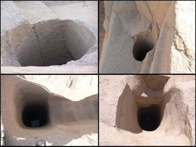
Figure 38. Photo from the Internet. The origin is not defined.

Figure 39. Photo from the Internet. The origin is not defined.
I think that they were made in the same technology, and were used as some storage containers required for conducting water works. Back then people did not have large size dishes yet. They did not know how to make barrels and cans yet. However, they knew how to crush granite. Some of these containers seemed to be designed to collect rainwater or wastewater.
One more fact can indicate the heating of rocks in the quarry. Near the monument people broke off another big piece of stone, but they did not do it with water (perhaps, the rocks had lost the desired temperature). They did it using wedges (Figure 40). My experience with granite blocks testifies that it is impossible to tear such thin layers from an array and to do it so evenly. It seems to me that this could be done only when granites did not reach their full hardness yet. Either they were not completely cooled down, or they had different mineral composition and strength characteristics. Only fragile material with low-tensile strenght can break this way. For example, it can be not fully set cement, ice or hardening epoxy resin.
It could be that having lost water on the surface they turned into something resembling a cracker, something fragile and friable. And only later, having received rain water, active silicic acid, which was in them, cemented them and attributed them modern strength.
By the way, limestone blocks of the Egyptian pyramids had a similar feature. They, in spite of their considerable sizes, are often framed by shell-like fractures indicating a momentary breakaway from the array. Moreover, they did not even retaine traces of tools with which they were broken off. This may be an indication of a very surfice force applied against the stone and, consequently, its fragility at the time.
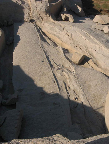
Figure 40. Chipping granite by means of wedges. Quarry in Aswan. Fragment from Panoramio № 18396981.
One problem challenging the proposed theory of granites’ processing is heat, which must have been felt above them. Could people work in such conditions? It is difficult to give a clear answer to this question because we do not know the temperature that the rocks had. However, people could reduce the heat coming from the rocks. The first thing that comes to mind is filling work area and walkways with gravel. May be, they could build a floor oversome walkways made of logs. And, of course, they could use water to cool their clothes and the surrounding heated surfaces that did not require further processing. When cutting blocks from underneath they could use wet brushes on long sticks or reed pipes. This, of course, was the hardest job. We can can only guess if workers had to go down the trench.
Works had to be planned in a way so that there would not be any difficulties with the removal of the products of the destruction. It would be even better if these profucts would be removed automatically being poured down and washed away by water. Perhaps, that is why the monument has a slope to the south-west possibly providing drainage of water. Figure 34 shows that a bypass trench had two stages. First, it had a wider section for a half way down, and then it had a more narrow section leading to the end.
In Figure 41 you can see how widely this method of stone processing was used. The whole visible surface bears traces of this technology. Besides, it is notable how few cracks in the rocks were there. Their absence we see in Figure 42 as well. This may testify in favor of a younger age of granites. Generally, the more ancient the rock, the more fractured it is. It is clear that the earlier rocks were formed, the longer they were exposed to tectonic processes that compress and crush them, hence, the more intensely they are cleavaged (cut by mutually intersecting systems of small cracks without noticeable shift of the rocks). For granites, which were formed in the Precambrian, − this age is ascribed to Aswan granites by a geological map of Egypt published in 1981, − they look very fresh, and it was more than 500 million years ago!
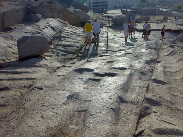
Figure 41.
In Figure 42 we can see arched character of the array and the cover that was concealing once red-hot mass. Besides, we can see mentioned above absence of fracturing.
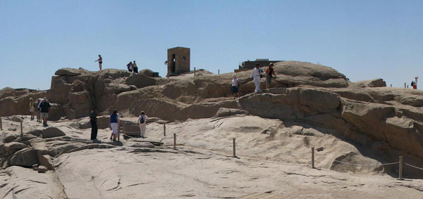
Figure 42. Covering of granites. Fragment from Pfnoramio № 12900664.
Returning to the beginning of the section one may ask what were the projections on the granite facing of the pyramid of Menkaure? In my opinion, they are the remnants of "legs", on which the stone stood until the last moment of its undercutting. The projections on the blocks of the Temple of the Sun in Ollantaytambo had exactly the same function. That is why their surface resembles that shown in Figures 35 and 36. After the block that was separated from the array cooled down, builders had to work with a hammer in order to remove these legs.
Another indirect confirmation to the outcropping of hot granitoids in this place is the presence of many unusual columnar formations of rounded shape in the course of this part of the Nile (below the Aswan Dam and up to Elephantine island). Accoring to the space photos this is the zone of the largest displays of arched deformation structures in the area.
When swimming in the boat and seeing them I thought they were some unusual erosional farewell rocks. I am sure that most of geologists would think the same. Now, I doubt it. Their roundness, most likely, has nothing to do with erosion or weathering. They were formed in the process of sharp squeezing onto the surface and cooling with water, which they went through. As a result, overheated blocks cut by cracks lost their sharp edges. They fell off because of the thermal shock caused by cooling.
Water existed here even in those days. However, it was not the water of the Nile. It seems, there was a freshened bay here, which may have been connected to the sea not far from this place. In the sand on the banks of the Nile there are a lots of modern marine microfauna. So, the Nile is not that old after all. It appeared after the reorganization of the relief, that is,only a few thousand years ago. It is possible that the delivery of blocks for the first pyramids and monuments was conducted by dead-water.
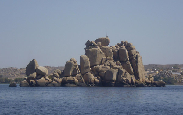
Figure 43. Granite outcrops in the mainstream of the Nile. Fragment from Panoramio № 51241408.
Granite blocks in Figures 43, 44, and 45 remind pillows due to their roundness. This analogy is often used in geology.
Pillow-like jointing of prestressed rocks is found in nature quite often and is interpreted by geologists as an evidence of underwater outpouring. Usually it is characteristic of basalts. When contacting with water overheated liquid lava flows crack and split into pieces due to water penetrating into the cracks. Each piece in the process of rapid cooling acquires shelly-concentric internal structure, which makes it look like a pillow. These basalts are called spilites.
Here we have almost the same. The only difference is that granites are always not as hot as basalts and nothing else happened except breaking off the angles denoting the crack inherent in them.
Figure 45. Photo number 67095160.
A few years ago when I wrote an article dedicated to megaliths of Brittany I noted that the surface of many of them seemed to bears traces of fire and I explained it by the impact of campfires or wildfires. Now I think that, perhaps, people there also used water for processing stone. Images that look like watering pots repeatedly occur on such rocks. Note the cross-section of large menhir representing a rhombus with rounded angles (Figure 46). The easiest way to achieve this was to treat a hot stone with water. It seems, that even the edge in the foreground confirms this. It is indicated with a red arrow showing the initial position of the monolith. Here, too, we do not see any traces of rock cutting tools.
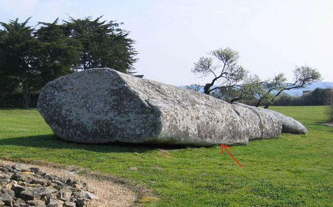
Figure 46. The Great Broken Menhir in Locmariaquer (Fr).
I would not dramatize the error with dating of granites in Egypt. First, Precambrian age of Aswan granite was cited from a geological map of Egypt with scale 1:2 000 000 (1981), that is, this was not a very detailed map. Perhaps, in some large-scale maps, which I could not find, they mark out later granite massifs near Aswan.
Second, geologists could easily miss such local implementation of younger granites within the field of development of rocks that were similar in composition. But even if they had not missed them, the assessment of their age in such a geological position without defining relationships with sedimentary strata would seem to be extremely arbitrary. Even the analysis of the absolute age would not add to the accuracy. Sure, no researcher would risk losing one’s head defending the truthgulness of the results obtained by this method. The problem is that it is unknown what is being determined: the age of sedimentary rocks from which these granites occurred; the age of the parent rocks from which sedimentary rocks occurred that produced these granites; the time when their re-melting and turning into granite began; the time when granite mass underwent autometasomatosis (changing due to its own thermal springs); when their invasion into the surrounding rock began, or when it ended and rocks began to solidify. There can be lots of versions, and all these factors can affect the test result to some extent. All these are the problems which geologists try not to think about because it is impossible to find the answer. However, they readily manipulate with these things when received dates are not very consistent with existing ideas.
Third, error may happen in the process of compiling a geological map while generalizing and assigning certain igneous complexes to a particular age − geology is still not an exact science.
Whatever the case, it would be very useful to conduct specific geological and geophysical studies in Aswan. Especially because it is possible to check the suggested hypothesis. Traces of recent presence of a magma chamber should have remained there. Otherwise, it might turn out that all these mysteries in the ancient quarry were the work of the Soviet builders of the Aswan Dam. I came across with this version somewhere.
Speaking of the inaccuracies in determining the age of the granites I will mention Peru. The error there can be considered as an admittable one. In a geological map of the country with the scale of 1:1 000 000 the age assigned to granites in the area of Machu-Picchu is KTi, that is, in the range of Cretaceous-Tertiary period. The latter, as we know, was followed by Neogene, which ended 2-3 million years ago. Thereby, Peruvian geologists actually admit that in the eastern part of the Andes there could be very young, almost modern igneous rocks.
Returning to South America
So, to separate blocks of the array people could used water. Just as now we use thermal baffle plates to contour large blocks with cracks for the subsequent separation them from the bottom by means of a gentle explosion, in ancient times, cracks could be made by water. Only they made them on all sides.
This way, most likely, huge blocks of the Temple of the Sun in Ollantaytambo that we mentioned above and all other blocks were achieved. That is why they have neither usual traces of drill holes by means of which blocks get split nowadays nor traces of tools that are presently used to process the surface.
Dents on the surface of a 45-ton block in Figure 30 indicate high temperature of porphyry, which composes these blocks, in the process of mining. Once it was separated from the place it was still hot for some time and retained some flexibility. Then, it could be transported by log rollers. Some log irregularities could leave these periodic prints on the block.
Extracting of these blocks was conducted, most likely, during the initial period of the activisation of the relief reconstructing when the top of the hill where this temple stands now was significantly lower and it was not so difficult to drag the blocks there as it would be today with the sloping of40 degree and the slopes being covered with sliding talus and rocky cliffs. That is why (according to a legend) an Indian king failed to drag a block onto the top of the hill even with help of thousands of workers. This endeavor ended by the block rolling down and running over lots of people.
Restructuring of the relief caught builders the Temple of the Sun in Ollantaytambo of guard when they were transporting the block fron the opposite side of the valley. It is possible that in those days the latter presented something like a fjord, and blocks could be transported to the other side on rafts.
One of the activation phase of the reorganization of the relief, which led to the growth of the Andes, could cause catastrophic draining of water out of this and similar pools. Volumes of water running down could produce many of the destruction that we see in Ollantaytambo and which puzzle researchers even now. They suggest an explosion or a wave with a height of several kilometers caused by a meteorite that fell somewhere in the ocean. Dozens of huge blocks were moved from their places or thrown from the hilltop to the its foot. Earthquakes and tectonic cracks that got revived under the structures could contribution to this disaster as well.
Prints on the blocks of seamless masonry that appeared due to neighbouring rocks also represent a certain puzzle. They can reach a depth of 1-2 millimeters and they can be seen not only in Ollantaytambo, but also in Coricancha in Cuzco (Figures 47, 48).
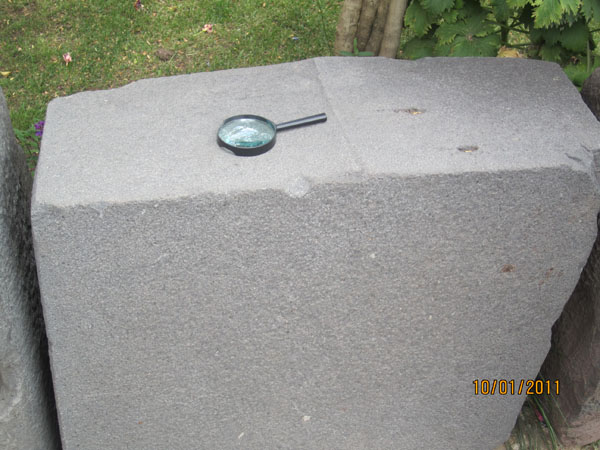
Figure 47. Block with an imprint of a higher standing block in Coricancha (Cuzco).
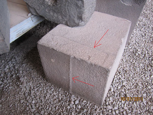
Figure 48. Prints made by neighboring blocks.
If we assume that the origin of such nuances of the surface is a result of hand-fitting of blocks together, somebody would have to explain me the mismatch between thin low-contrast relief and rather rough surface of the stone. This mismatch seem paradoxical to me as a stone-worker.
If a modern stonemason had a task to adjust blocks so tightly that a paper would not fit between them, he would have used more and more sensitive instrument as he would be approaching the end of his work. At the last stage, he would, perhaps, use even finish. And it would, of course, smooth the surface of blocks being fitted. In our case the surface of the stone is so rough that it does not give any reason to think of any fitting. One could assume that the rocks, from which the blocks were made, remained a little plastic some time after the installation. Then, under the pressure of the overlying rows the gaps between the blocks disappeared. The roughness of the surface in this case was caused by granulity of the rocks and not by the character of processing.
Nowadays we can observe significant plasticity, perhaps, only in marble. Under the force of gravity its crystal structure changes fast enough. But, apparently, there was time when this process involved a wider range of rocks, which were in the process of adaptation to new conditions.
All mentioned above does not mean, of course, that the blocks were not processed prior to theinstallation or were not adjusted to each other. All this was done, but surprising precision of neighbouring blocks formed by itself some time later.
A few words about Sacsayhuaman
On a small spur of the northern side of the intermountain depressions, in which the city of Cuzco is located, you can see an amazing structure, the purpose and the building technology of which was lost in the mists of time. This is Sacsayhuaman. Three lines of its walls, raised to different levels, protect the hill from the north, on the top of which there are foundations of some buildings. However, the visitors are more attracted not to these ruins, but to the walls, which, as it seems at first glance, had to protect something. The most interesting thing, however, is not the walls themselves, but the material they were made of and how they were made (top view and a panorama of Sacsayhuaman wallscan be seen below in Figures 52 and 53). Weight of some blocks reached 100-150 tons, and there were not a few of them. However, just like in Machu-Picchu and Coricancha even a match could not be stuck into the seams between the blocks. Configuration of the walls also causes surprise. Not only were they, for some reason, located on a hillside in tiers, one above the other, but in plan they form something like the teeth of a saw. Moreover, these teeth all have asymmetric shape. Below, in telegraphic style, I am going to present the main results of my observations and conclusions. They must be perceived as the most preliminary.
Sacsayhuaman wall blocks consist of microlithogranular limestone (dolomite). This is confirmed by microsections of the samples that I was able to pick up at the place of outcropping of similar rocks. By the nature, these sediments are of bio-chemogenic origin. In some blocks thin lamination is present, and microsections have something similar to the remains of organisms, which further confirms their sedimentary, not igneous, origin.
Outputs of such limestones are widespread in the vicinity of Sacsayhuaman. In plan they have more or less rounded shape, often limited by steep walls. In addition, they are subdivided into giant blocks by faults, between which caves and tunnels were sometimes formed. On the surface they are covered by systems of orthogonal open cuts of anthropogenic origin, and usually do not have soil cover. One of such arrays – Quenco − is shown in Figure 49. Another one (maybe, unnamed) is shown in Figure 50.
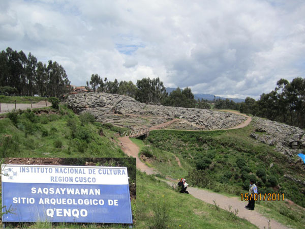
Figure 49. Quenco. Magnification allows one to see lots of stepped open cuts on gray outcrops of limestone on the left.
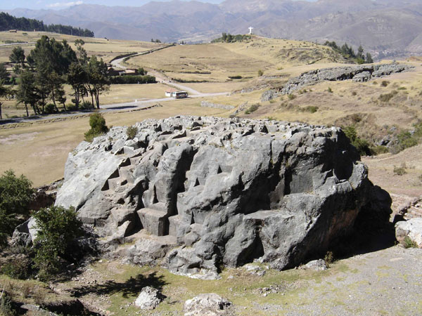
Figure 50. Another limestone massif near Sacsayhuaman. Its surface is all cut with steps. In the distance one can see white cross-shaped statue of Christ. Panoramio № 1704488
From the north, opposite Sacsayhuaman, there is a hill formed by lava flows of andesidacite. We saw them in Figure 23. A view of this hill from the "Fortress" is shown in Figure 52.
As I already wrote, the presence of glaze crust covering the lava flows is quite usual for volcanic flows. It appeared due to extremely fast cooling of liquid melt, during which the material did not have time to decrystallize and was like glass. Especially often such crusts cover underwater eruptions of basalt. Although, it is possible that it was raining here at the time of the eruption or, may be, the melt was going through the water.
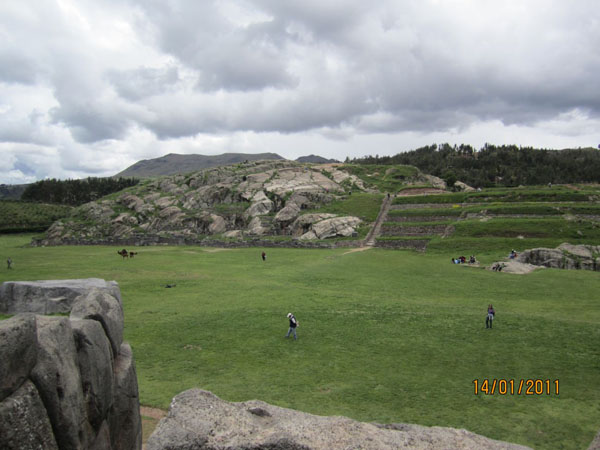
Figure 51. Lava hill opposite the walls of Sacsayhuaman. Small hills shown in Figure 23 are located from behind.
The purpose of a three-level cascade of Sacsayhuaman walls, in my opinion, has nothing to do with defensive purposes. First, the walls do not frame the hill completely. The side facing Cuzco is not only devoid of any obstacles, but, on the contrary, is terraced (Figure 52), which makes it easier for enemy to snatch a foothold. And, second, the walls are easy to overcome both due to their irregularities and their small height.
Another excessiveness is their three levels, gradually decreasing in height from the bottom line to the top one.
The purpose of the walls, in my opinion, is about the same as the purpose of Carnac rows in Brittany. They collected silt and residues from vegetation carried by water. This explains their castellated shape and sloping to one side. Naturally, all happened before the reorganization of the relief, when the intermountain depression, where Cuzco is now located, was not at the height of 3300 m but was only slightly elevated above sea level and was filled with water. There was an island, which became a peninsula at times of low tide and on which people settled. During water rise it was flowing around the hill from the south and the north moving from west to east. Behind each tooth of the wall a shadow zone was formed which accumulated light material: clay and organic silt. During low tides people collected it, probably carried over to bare rocks, and used as soil. As a result of tectonic processes, known to us, the hill grew up and the upper wall (the lowest one) gradually came out of the flood zone, hence, stopped functioning. Then the second wall was built, which after some time also died out. Finally, the last wall was made (the highest one). Between them, as on the terraces, agricultural plantations maight have been organized.
Figure 52. Top view at Sacsayhuaman. On the south under the slope Cuzco begins. In the center, in the top, there is a part of the hill presented by lavas of andesidacite composition. An arrow indicates the wall.
I do not know how the water level changed after the beginning of the activation of the mountain building process. Before disappearingn forever waters could rise above the level of all the walls. This version can be confirmed by the fact that the western flank of the lower belt of the walls is immersed in sediments (brown clay) to a substantially greater degree than the eastern one. So, the height of the walls there is smaller now. This is evident when using magnification in a panoramic photograph (Figure 52).
Figure 53. View at the walls from a volcanic hill in the north. The height of walls decreases from east to west. Panoramio № 54910205.
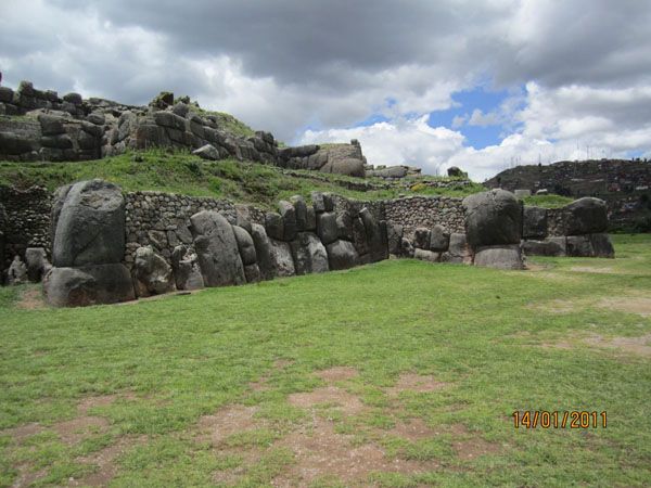
Figure 54. This is a western flank of the walls. Here it is clearly seen that some of the lower blocks are almost completely covered by sediments. Height of the walls here is 2-2.5 m compared to 6-7 m at the eastern flank.
Archaeologists should get interested in the very fact that the walls are immersed in sediments, and that these sediments do not present an artificial mound at the foundation. They lie between two hills like an even cover. How could they appear here after the construction of the walls? This is a good question to ask. Floods could not possibly bring so much clay, because now Sacsayhuaman is raised over Cuzco with a small river of about 200 meters.
Finally, I am going to mention how the wall blocks were being made. The biggest of them, it seems, were cast in place using plastic silt, which was squeezed out of the ground in areas of limestone outcrops or was obtained by pugging of not yet hardened calcareous material with water (similar to torba-floor in the temples in Malta). Sometimes in these blocks one can see pieces of the same material, traces of formwork, the abundance of voids and large shrinkage cavities filled with carbonate. The latter are the traces of shrinkage of the solution.
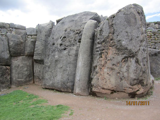
Figure 55. Larger blocks of the lower wall. Their hallmark is the abundance of defects. Weight of some blocks reaches 100-150 tons.
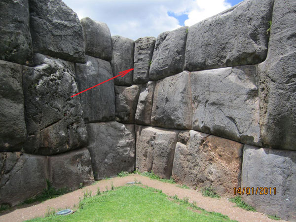
Figure 56. Traces of formwork.
However, there are lots of blocks, especially smaller ones in the upper rows of the masonry, which were clearly cleaved from the array (Figure 57). They often have irregular shapes and tightly join neighboring blocks only in the front (Figure 58).
Figure 57. Back view at the top row of the bottom wall. It can be seen that the blocks are completely different in size and have irregular shape indicating that they were not cast.
Figure 58. Back view of the upper blocks. It can be seen that they fit together tightly only in the front.
Finally, a lot of questions are generated by the character of the surface of many calcareous massifs like Quenco and the other one, which is shown in Figure 50. Why did people make so many wailings there.
In my view, this way the ancient people adapted their surfaces, which were very rough and cavernous, for living. During the periods of high water, these arrays transformed into islands and people gathered on them in anticipation of low tides. There they lived, slept, ate, and moved around. For all of this they needed horizontal surfaces that were eventually made by them. They became shelves, tables, chairs, beds and… even toilets (Figure 59). This is South American natural analogues of the European mounds and tumuli, where people also lived during floods (see the article about the megaliths).
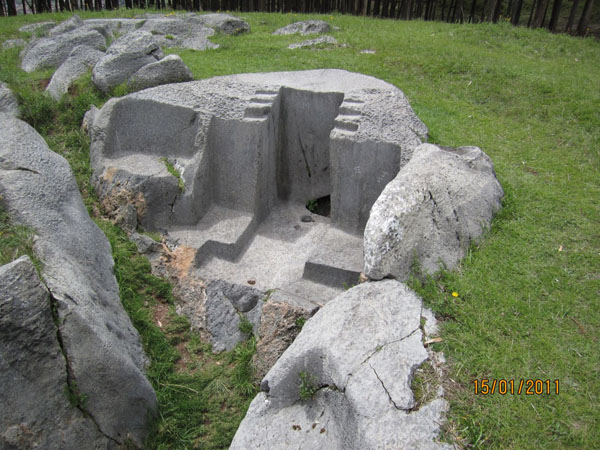
Figure 59. Watercloset? Quenqo.
In addition to a large number of horizontal open cuts, such arrays often have stairs as well. Sometimes they start from the ground, and it was easily to climb them onto the island, some other times stairs are presented in form of small fragments on the surface overcoming irregularities. Often these limestone arrays are dislocated by faults due to which voids and cracks were formed inside them. Interior spaces of such cavities were often refined too. They were expanded and equipped with steps (see photo from Panoramio on Quenqo).
After the active phase of the reorganization of the relief, many of these underground halls collapsed, parts of massifs were displaced with respect to one another, in some cases huge chunks fell off them and even got scattered around. These chunks preserved fragments of the former walls and ceilings.
Perhaps, some time after the disaster people continued to live in these places, but the land that got lifted up and was longer subjected to periodic flooding made these places useless. People began to settle around occupying the land along rivers and water reservoirs where they still live now. After the reorganization of the relief there was plenty of dry land where people could plow and sow without any fear that water would wash away everything. This is why Sacsayhuaman was forsaken.
However, there was one time when its massive walls provoked Indians who had revolted against Spanish oppression to organize their defense there and use this structure as a fortress. The rebellion, of course, was suppressed, but the reputation of Sacsayhuaman as military facilities only strengthened.
| << Previous | Contents | Next >> |


