

To display the site correctly, please, enable JavaScript.
Chapter 2: Surrounding Area
| << Previous | Contents | Next >> |
Now let us consider the geoglyphs and their situation in the immediate vicinity of the first route. We will be
doing this only by studying satellite images because I could not visit these places, but the places seen in the
first route will allow to imagine adequately how it all actually looks. The interpretation of the territory, as
geologists call this, was completed.
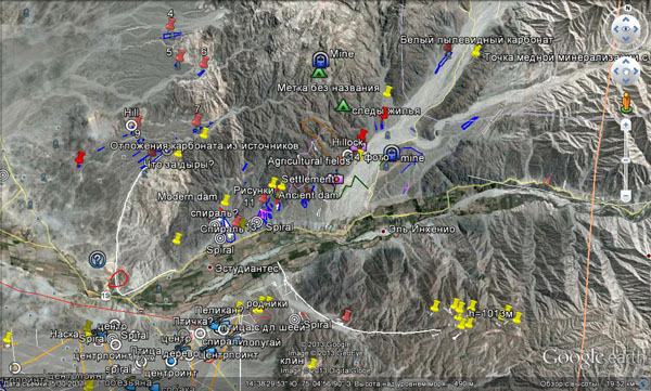
Figure 1. Surrounding area of the first route.
Let's start with the next valley located higher along the dry inflow of the Ingenio river from the first observation point of the first route. 1 km from its mouth, almost at the slope there is a wedge (Figure 2). Like the previous ones, it is located on a small elevation surrounded by numerous washouts on the sides. The length of the wedge is 100 m, the width is about 20 m. It widens downward in the direction of the drain. The sides of the wedge are slightly curved in conformity with the curves of the most washouts in this place. (NB: As you can see, straight boundaries are not necessary). Either a washout or a small ditch enteres the wedge at the top. In the lower right corner of the wedge one can see a break of the border, from which a light apron begins. It appears to be the trace of the water flow. There are no washouts on the elevation itself, but there are some bright spots. We know whatthey looked like closely. The situation in this place continues to point to the connection of geoglyphs with water.
Moving 1 km to the south to the mouth of the valley.
Here, on the terrace adjoining the hills on the south and divided by the bed of the formerly existing stream one can see a few wedges (Figure 3). They are slightly longer than the previous ones, but they also widen down the slope from north to south. Lines-ditches enter two top wedges and follow their axes. These ditches originate in the north at the stream beds. A line also goes along the right side of the lower wedge. This line starts from the bed of the stream, but it does not enter into it. The wedges themselves are located on most enen part of the surface and are scarcely cut by washouts. However, the approaching ditches are crossed by small depressions (white arrows in Figure 3), which would immediately capture water, if it flowed over them.
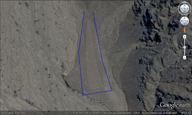
Figure 2. A wedge at the border of the valley. A ditch enters the wedge at the top; in the bottom right corner one can see a washout and an apron.
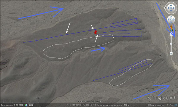
Figure 3. Wedges in the mouth of the valley. Attention, NORTH is on the left! The white line circles the areas of the spreading of light spots.
Besides, when you zoom in, you can see lots of light spots. Most of them are confined to small swell-like elevations (these areas are marked with a white line).
Let’s continue to move to the south and stop in the first underlying valley, which we have almost reached in the first route (Figure 4). In fact, it is the Ingenio river valley.
Figure 4. Wedges.
Here, on a triangular terrace, which divided the water flowing from the mountains into two streams, one can see two wedges fanning from the top. The surface of the terrace has a slight slope to the south, and the wedges are widening in the same direction. Their length is a little more than 100 m, their width at the bottom is less than 20 m. There are lines going from the tops that join at the northern end of terrace, where it has the lowest height. We can assume that in the past the surface of the terrace here was at the same level as the surrounding depressions and the ditches could be filled with water flowing from the washouts. There are some bright spots here as well, but they are not numerous.
The next site located further on the same side of the valley is shown in Figure 5 and in Figure 6 in perspective.
Here, as in the previous case, the geoglyphs are located on the terrace, which has a triangular shape and a gently incline to the south. There are three large wedges fanning from the northern end of the terrace. Their length reaches half a kilometer and their width is 60-70 m. Despite their size, the arrangement of the wedges is identical to those on the previous site. Their sharp tops also turn into into lines that originate under the slope of a small mountain at the inflow of a small stream. A close up of this place is shown in Figure 7.
Its mouth is crosses by the dam, which was likely to regulate water run-off and its delivery into the ditches that feeded the system in question. Below the dam at the foot of the slope we can see a lot of washous turning right and down, some of which are located under the slope.
The lower and wider side of the terrace is dissected by valleys. Spurs that got formed are covered with finer lines and wedges (foreground of Figure 6). Their arrangement possesses previous patterns – they are stretched along the line of sloping and are widening downwards.
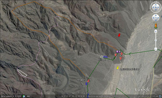
Figure 5.
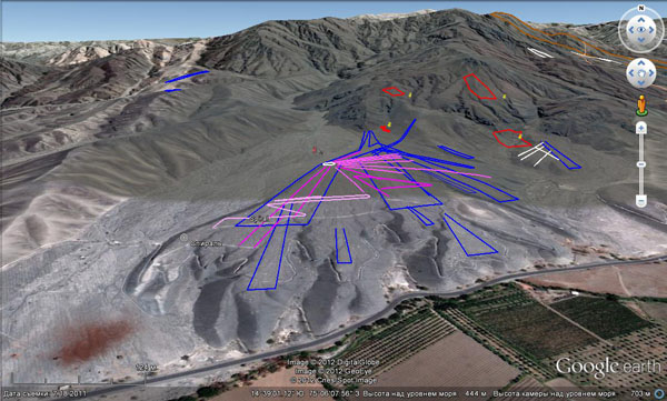
Figure 6. The site in perspective.
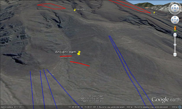
Figure 7. An ancient dam and a wall at the foot of the slope.
In Figure 7 we can see another wall located next to the stream valley, parallel to the foot of the slope. Its functions are not quite clear but there are lots of such walls and ancient dams in the area. Sometimes they are situated in a few belts, and in all cases that I've seen their slopes were very steep. Depending on their height − no more than half a meter − they were apparently designed to prevent the sliding of the soil from the slopes. However, during an excursion to the so-called Pinchango Alto Fortress, our guide presented them as shelters, from which some alleged defenders threw stones (?!) at the aggressors.
Figure 8 shows a perspective view of the right part of photo 6.
Figure 8. (For orientation there is the ancient dam and the wall in the upper left corner.)
Here, too, there is nothing new in the position and widening of lines and wedges. A wedge and lines are located on the flat terrace surrounded by depressions with washouts. In the watercourse of one valley there are some objects that we have not seen yet. They are marked as «settlement». In Figure 9 wee can see what they are.
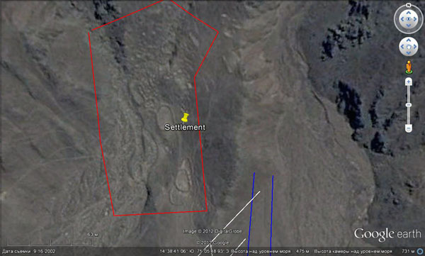
Figure 9. Settlement.
They are oval sites framed by low walls and confined to the valleys. They occur only in the places where there is a cover of soft sediments on the slopes. Based on this, we can assume that they are the cascades of small fields similar to those in Southeast Asia. Their attraction towards the bottom of the valley is conditioned by better watering of this zone.
Going back to the previous site, let us note that there are also other lines that radiate from the center located on the western edge of the terrace (in Figures 5 and 6 they are marked with pink color). They appear to be more ancient than the wedges because they are covered by them, though sometimes they “transpire” through them. At the point where they originate, using high magnification, one can see the stone circles up to 5 meters in diameter. This is how small bowls of water springs could be reveted.
It is here that for the first time we encounter another form of geoglyphs, that is, serpentines. They are zigzag lines descending down the slopes like mountain roads (Figure 10). Unfortunately, the abundance of hindrances does not allow to restore each of them separately. Usually we can observe only their fragments, but they seem to be a subject to the general pattern as well − their center line coincides with the direction of the surface incline.
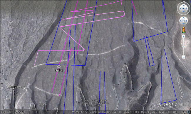
Figure 10. The fragments of serpentine.
In the bottom left coner of the terrace one can see another kind of geoglyphs, that is, spirals. There are two of them here with a diameter of 30-40 m. They are not perfectly round and you cannot see either the beginning or the end, but both are double. Using magnification one can see a loop in the center of the spiral, i.e. the twisted line does not end in the center but makes a half-turn and spins. There are dozens of such figures in the region (Figure 11). We will deal with them a little later.
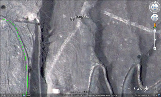
Figure 11. Spiral.
In Figure 12 we can see another extremely widespread phenomenon in the region, that is, conical depressions or cones. Here they can be seen on the surface of the terrace near the bench and at its foot. Their diameter is a few meters, their depth is 1-2 m. They are found only in loose ground such as sands and gravel. Most often they are localized on the surfaces of lower terraces, under the slopes and in the valleys of larger rivers. They have no direct connection with the geoglyphs, but they very often coexist with them or other man-made objects. This was one of the reasons why their origin was considered to be artificial. In particular, the American archaeologist Helaina Silverman while observing many of such cones in the sands near Cahuachi, which she excavated, perceived them as signs of gave robbing of ancient tombs. If one accepts this point of view, we would have to admit that the region was subjected to total robbery because there are hundreds of thousands of such cones in the Rio Grande Basin.
Figure 12. Conical depressions.
In two last photos you can also see many white spots. They were in the previous photos as well, but in smaller amounts.
A nearly identical picture of the arrangement of lines and wedges is presented in Figure 13.
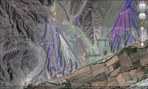
Figure 13. Wedges, lines and fragments of zigzags on the terrace on the right bank of the Ingenio river opposite Estudiante and modern fields prepared for occasional use (circled by a green line) as well as those that are used continuously.
There are wedges, lines, zigzags (serpentines) and spirals on two triangular terraces (the western half of the photos) widening downward. They are surrounded by wide valleys resembling horse tails covered with traces of dried-up riverbeds. On this site the lines are even closer to farmland. Extensive fields, abandoned or waiting for floods, adjoin the left side of the terrace (the center of the photo). Here in the Ingenio valley we also see some functioning fields opposite the places of the concentration of geoglyphs. There is a curious object resembling a dam or a dike in the upper left corner of Figure 13. It blocks the channel below the confluence of three tributaries after they flow out of the mountain ravines. It obviously has a modern origin and it is rather strange because there have been no rains in Nazca for many decades and the headwaters of these tributaries do not reach to the highlands of the Andes for tens of kilometers. Maybe the local people do have something to hide from the general public? Or, may be, the fans of lines do not really want to know this and follow the line of Pushkin’s poetry saying that “A deception that elevates us is dearer than a host of low truths”.
Now we will move from the Ingenio valley to the north to the next parallel valley, the length of which is about 10 km.
The relief in its lower part has a slightly different character compared to that which we saw earlier (Figures 14 and 15). Here the surface of the valley is represented by the alternation of narrow ridges and depressions with flat tops and bottoms. The depth of the latter reaches a few tens of meters. The slopes, according to the photo, are mostly talus, hence, they are steep. The youngest deposits are channel alluvium of a pale gray color. Valleys cut the surface of the ancient terrace (darker colour) covered with loose deposits, on which wedges and lines occur.
All of them are organized by the same principles − lines and the axes of wedge coincide with the direction of the water flow. Wedges are everywhere expanding downward and their sharp peaks always point to the upper parts of the valleys. The tops of the wedges located in the lower half of the photo are entered by the lines that originate on a small hill (!) at the foot of the pinkish mountain in the lower right corner of the photo. The lines are stretching along narrow flat watersheds for a few hundred meters.
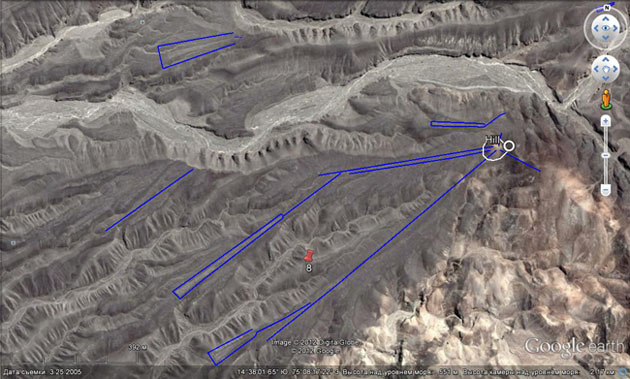
Figure 14: The view from above.
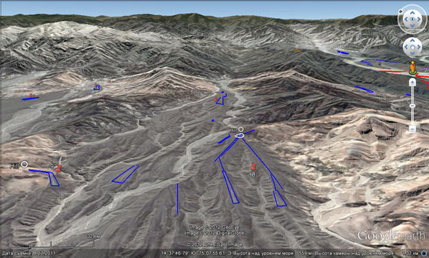
Figure 15. A perspective view of the valley with wedges from the south-west. The line of the first route can be seen here in the upper right corner (red).
Figure 15 shows a perspective view of the valley from the mouth. The abundance and consistency in the arrangement of the wedges in this remarkable picture seems to be able to shed light on their nature. Let's go deep into this situation.
We have the following. The surface of the bottom of the valley is sloping towards us. There are a few lines on the narrow flat tops. In most cases the lines are completed with wedges arranged as usual. The wedges themselves are extending downwards the valley. We have repeatedly seen all of this.
The first thing that came to my mind was that the confinedness of the wedges to the valley and their arrangement with sharp ends up was due to their resistance to the flow. Because of my view of the modern relief as something rather new, I did not take into account that all of them were located on the terraces that were 10 or more meters above the valley. I suspected that in the recent past all of them were located on small elevations of the same flat surface of the depression. It seemed that their sharp noses could cut the flowing water, while the ramparts of stones along the contour were supposed to protect the interior. The assumption concerning the flowing water was supported by the presence in the valley of several channels with a great number of washouts.
The idea that the stone ramparts framing the wedges could be overwatered, came to me repeatedly while walking along the routes – their profile was too smooth, as if it sank in the water. A weak point of this version was their height, clearly insufficient for the protection of the internal space of the wedge. The rise of water by half a meter or a meter would make them useless. Another weak point was the presence of such element as a line-ditch which would have had to be redone after each flood.
A close examination revealed some other features of the wedges that did not agree with the above mentioned version.
When zooming in it turned out that the tops of the wedges seemed to be sharp only from a distance. In fact, in most cases they were cut at a straight angle. One of the examples is shown in Figure 16. However, in this form they were unlikely to be designed to cut water flows.
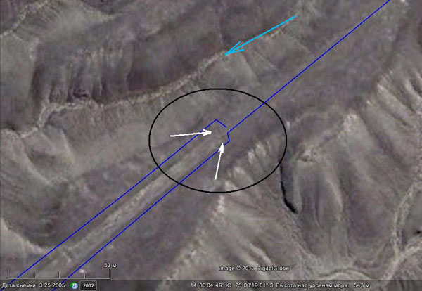
Figure 16. The top of the wedge. White arrows point to heaps of stones at the entrance of the line into the wedge.
Another inconsistency was that at the entrance of the line into the top there were two dark points to the right and left. They were two heaps of stones. In case if the wedge resisted some water flow it would be more logical to put here sharp stone heads bigger than the stone ramparts framing the wedge on the sides. But we do not find this. However, two symmetrically located heaps at the entry of the ditches are present almost constantly not only here but on other wedges as well.
Hence the conclusion that the proposed version is incorrect and the wedge shape was unlikely to be born out of the need to resist the flow although the connection of wedges and water seems unquestionable. Let’s keep this conclusion in mind and continue our study of geoglyphs.
Now we will move down the Ingenio river valleyto the left bank near the place where it joins the Rio Grande (Figure 17).
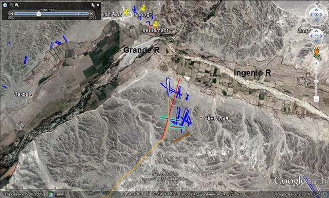
Figure 17. Areal map of the mouth of the Ingenio River.
Here, on a low plateau cut by small valleys one can see a lot of lines, ribbons and wedges.
We will sart with wedges. The first of them is shown in Figure 18. Its top is located on the slope of the bench and descends into the valley. Its length is more than 500 m.
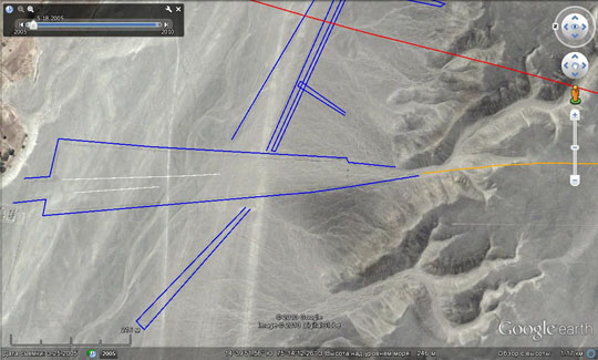
Figure 18. A wedge starting under the bench. NORTH is on the LEFT. The scale in the upper left corner shows that this is a satellite image made in 2005. Shooting of this place on 3.6.2010 is of some lower quality due to clouds.
Zooming in Figure 18 allows to see that the top of the wedge is entered by lots of wasgouts. The largest one almost coincides the wedge’s axis. To the right and left of it we see two dark spots − heaps of stones. The close-up of this site is shown in Figure 19. Washouts, branching and meandering, do not go to the end of the wedge. In its middle they unite into a single channel, which turns and runs along the foot of the bench to the north- west (Figure 18).
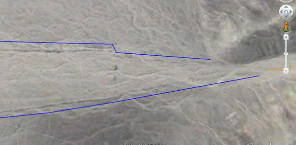
Figure 19. The close-up of the tip of the wedge.
Other wedges begin in here in a similar way (Figure 20). There are two systems that can be clearly seen among them. The first group starts on the slopes and stretches along the washouts flowing from these slopes. The second group is located at their bottom of the slopes. The latter crosscut the former, that means that they are more recent and are stretching along the flow line of the main valley. But even they start with washouts.
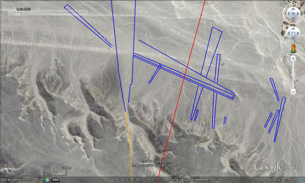
Figure 20. Two systems of wedges.
This is the first (low) level of the wedges. If we go up to the bench then southward we will see the second level. Figure 21 shows marked benches and computer horizontal section of the relief along the line AB.
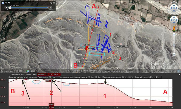
Figure 21. The map of the wedges and benches with the horizontal section of the relief.
The geoglyphs of the second level are shown in Figure 22.
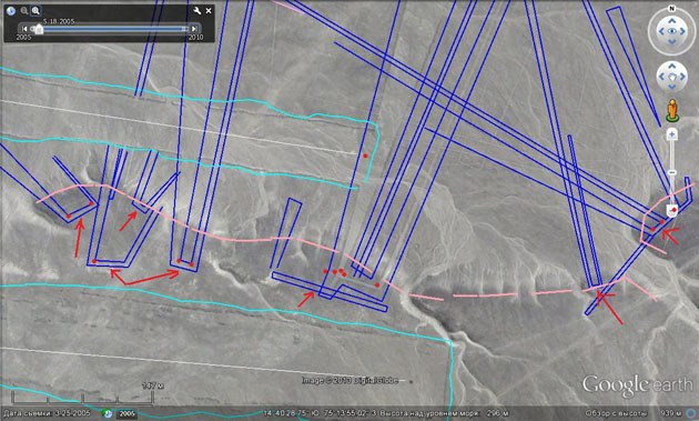
Figure 22. The geoglyphs of the second level. Blue colour marks wedges and lines. Turquoise colour marks irregular ribbons. Pink colour marks the edge of the bench. Red dots mark the piles of stones.
The largest wedges have a length of about 700 m and the width at the ends of about 100 m. The surface on which they are located is slowly lowing towards the edge of the first bench. The height difference between the top and the bottom is hardly more than 20 m. The wedges here differ from the previous ones in that they do not start under the slope of the second bench, but higher − on its surface. But this is not the only difference. Their top is not sharpened or cut, as we have seen until now, rather it turns abruptly, almost at right angle, and transforms into a short narrow section of the ribbonrunning along the edge of the bench, which also turns sharply and goes back down from the bench. There are heaps of stones on the most of these turns.
All over the slope of this bench you can see many small washouts. It is due to their lighter color this bench becomes so visible. In some places it is crossed by larger washouts that originate on the slopes of the third (the highest) bench. It seems that the above-mentioned short sections running along the bench crest are meantto collect water flowing from above, while the heaps of stones served as some material, which was used to fill the approaching ditches in order to control the water flow. The excess water could be directed into a narrow ribbon connected to the wedge.
As in the previous case, small streams of water under the bench united into larger ones, which in turn merged into one channel. But this channel did not follow the wedges towards the edge of the first bench, it turned around to the north-west, thus indicating the lowering of the surface.
In Figure 21 this lowering is clearly seen on AB profile and is marked with a blue line. The same lowering occurs between the second and the third bench. It is here that some large ribbons of latitudinal strike parallel to the edge of the second bench are located, one of which is located underneath the bench, and the other one is located on the bench a little further to the south. In Figure 22 they are marked with turquoise lines. Simple logic tells us that in ancient times these depressions were the dampest places. Therefore one can naturally assume that they were ancient fields. The dimensions of the lower one is 800x60 m, while the upper one is 530x100 m , i.e. about 5 hectares each.
Stone ramparts that frame them were in many places washed out by water streams, the traces of which can be found inside. Characteristically, the fields’ boundaries are much less perfect than the border of other geoglyphs. Generally preserving the shape of a rectangle these boundaries sometimes deviate significantly from a straight line. It is especially true about the upper field. In the process of its usage it was clearly expanding and therefore it preserved the fragments of the former borders. The bourder was expanding to the north, therefore most of the remains are there. This is also indicated by the position of two large stone heaps on the western and eastern flanks which are displaced with respect to the axis of the field today. Such heaps are an indispensable attribute of such broad ribbons. Similar piles along axis we can see in the north of the Nazca desert (Figure 23). I think the heaps served as frames fixing the axial line of the future field from which it was being marked.
Figure 23. One of rectangular ribbons (fields) in the Nazca itself. At its end one can see dark heaps of stones.
Moving further to the south and passing the last field we come to the bourder of this wonderful cascade structure that ends with a narrow ridge with a flat top stretching out in the direction of NE-SW. In Figure 24 it is marked with brown contour. Its length is about 700 m, while an average width of the top is about 30-35 m. There are some images on its south-western flank as well as in the middle. Its slopes are of interest as well. From the very top they are covered with washouts which, on the way downwards, connect to lots of streams flowing westward to the nearest large valley. Considering the number of washouts and their intensity we can compare the slopes of this ridge only the slopes of the lower terrace forming the board of the Inhenio River valley from which we started our studies of this area. However, the abundance of washouts there could be explained by the water flow from a rather large surface of the first terrace. But what could flow down from the narrow ridge of 20-30 m wide? No showers could wash out the adjacent slopes to such extent.
And again we face the problem of sources, that we already had in our first route. The only thing that comes to mind seems impossible and contrary to all logic: may be water was oozing from the ridge itself?! Similar washouts and dry river beds exist on its south-east slopes as well.
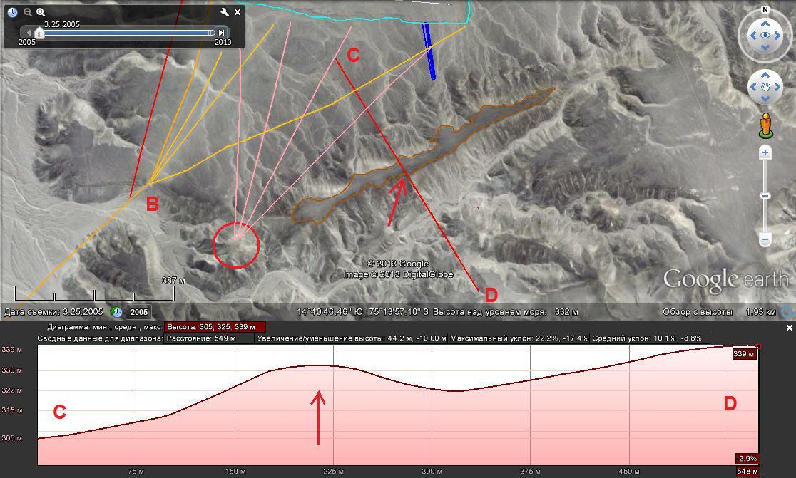
Figure 24. South-east ridge and its profile along CD line. The height of the section marked as 10-12 m is likely to be understated. The program averages and smoothes the relief. In reality it is 30-40 m.
Another interesting object can be seen 100 m to the south-west from the end of the ridge (a red circle in Figure 24). It is a small hill with a whitish top, blurred or rubbed (Figure 25). There are some bright spots on it and a few lines-ditches (pink colour) are running down from it northward crossing small valleys and washouts. This is a diminished version of one so-called “Centers” (Centrpoint) − from the tops of which side lines diverge. There are more than a dozen of such lines in Nazca and its surrounding area.
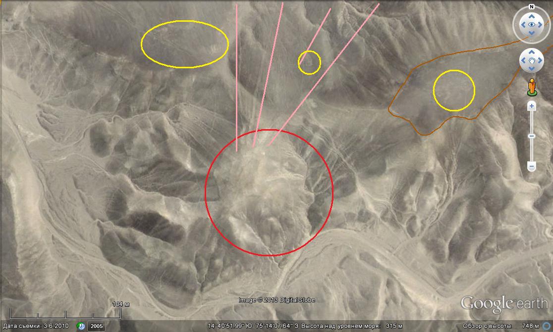
Figure 25. The so-called "Center" in the south-western end of the ridge (a red circle). Yellow circles encircle ancient drawings.
Figure 26 shows one of these centers in the Nazca desert itself. Some characteristic features like whitish color and rubbed surface are seen very well.
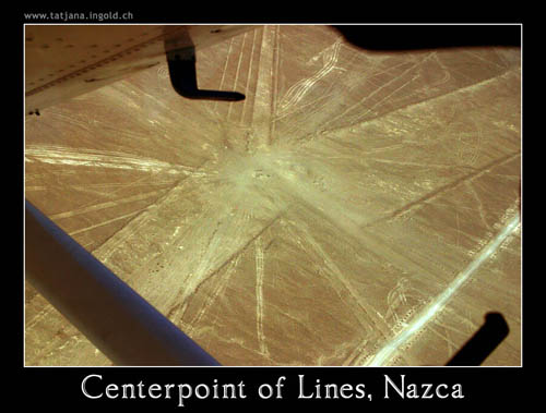
Figure 26. One of so-called “Centers” in Nazca itself. This airplane photo is taken from Panoramio № 1285898 . The authors’ website is in the upper left corner of the photo.
And now let us have a look at Figure 27. Almost all geoglyphs that I could see on this site are presented here. Blue colour designates systems with wedges, and pink colour shows lines. As you can see the latter are also quite numerous . They cross benches and flat surfaces of the terraces in all directions rather chaotically. Some of the lines have the form of a zigzag, they are descending upon the surfaces of the terraces like the wedges. One of them is in the top right corner of the photo and is highlighted by purple colour. There are even two of them here superposed on one another and differing in step. They originate from the second "Center" located on the north-west extension of the above mentioned narrow ridge.
All these lines could serve as a kind of exploratory ditches, the water content of which allowed people to decide how and where to lay the wedges. Zigzag systems could serve for watering of large areas.
Figure 27 shows that all the wedges are placed along the borders of the benches and stretch in the direction of the water flow. Exceptions are wedges in the Ingenio Valley. Their stretching is determined by the direction of the flow in the valley itself. Naturally, it is pointless to look for the connections of the direction of the lines with stars, planets or the sun. All matches will be random that was proven by the work of the group of Gerald Hawkins who did not see any significant correlation of lines with celestial objects.
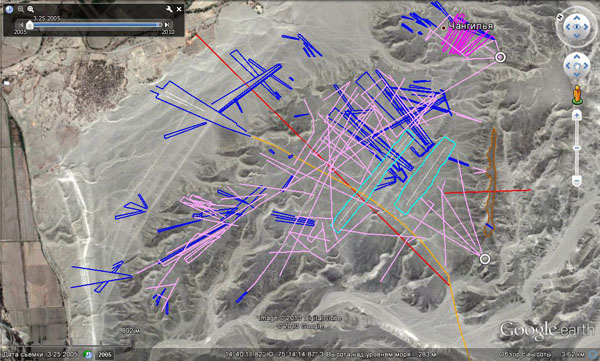
Figure 27. The structure of geoglyphs. Attention : North is displaced. Blue colour marks wedges, pink colour marks lines, white colour rings mark Centers.
Concluding the description of this site I suggest to have another look at Figure 19 with a close-up of a wedge being supplied by a washout.
In geology, there is a concept of alluvial cone. It is applied to sediment accumulations moved by rivers into the sea. They often have a conical shape and are sometimes cut by fan-shaped riverbeds (example: the Lena River delta). In our case, we have the initial stage of this process − the cone formed by washouts. The wedge that we see seems to fit well into it and presents a sector fragment of such figure. In order to irrigate it one does not need to “force” the nature. The water that got to its top will tend to spread over the surface. Maybe, one would have to adjust its flow a little bit by using artificial channels. Perhaps it was such cones that prompted ancient people to make their fields wedge-shaped?
Here we end our study of this site, and I hope that it removed any doubt concerning the connection between lines and water.
Let us continue our study of geoglyphs further on. Now we will move 20 km closer to the city of Nazca, where we will examine a dry valley bordering the valley of the Tierras Blancas River two kilometers above the town of Nazca. This valley begins at the foot of a local landmark − two-kilometer mountain Cerro Blanco (The White Mountain). The rivers Tierras Blancas and Ajo merge in Nazca city and form the Nazca River.
The position of the valley can be seen in Figure 28. Its mouth is marked with a camera sign. Figure 29 provides a computer prospect in the direction of the upper parts of the valley for a better view of the situation.
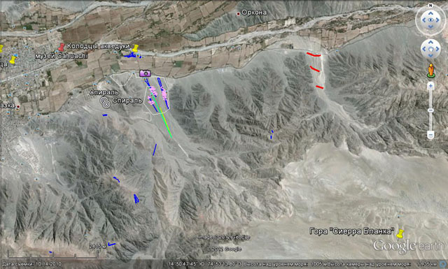
Figure 28. In the lower right corner of the image one can see a vast light mountainside of the Cerro Blanco. In the upper left corner one can see the eastern part of the town of Nazca.
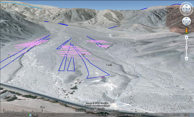
Figure 29. The computer perspective of the river valley from the mouth, from north to south. In the foreground there is the Cuzco highway. In the upper left corner above the blue line one can see the northern slope of the Cerro Blanco, towards which the valley turns.
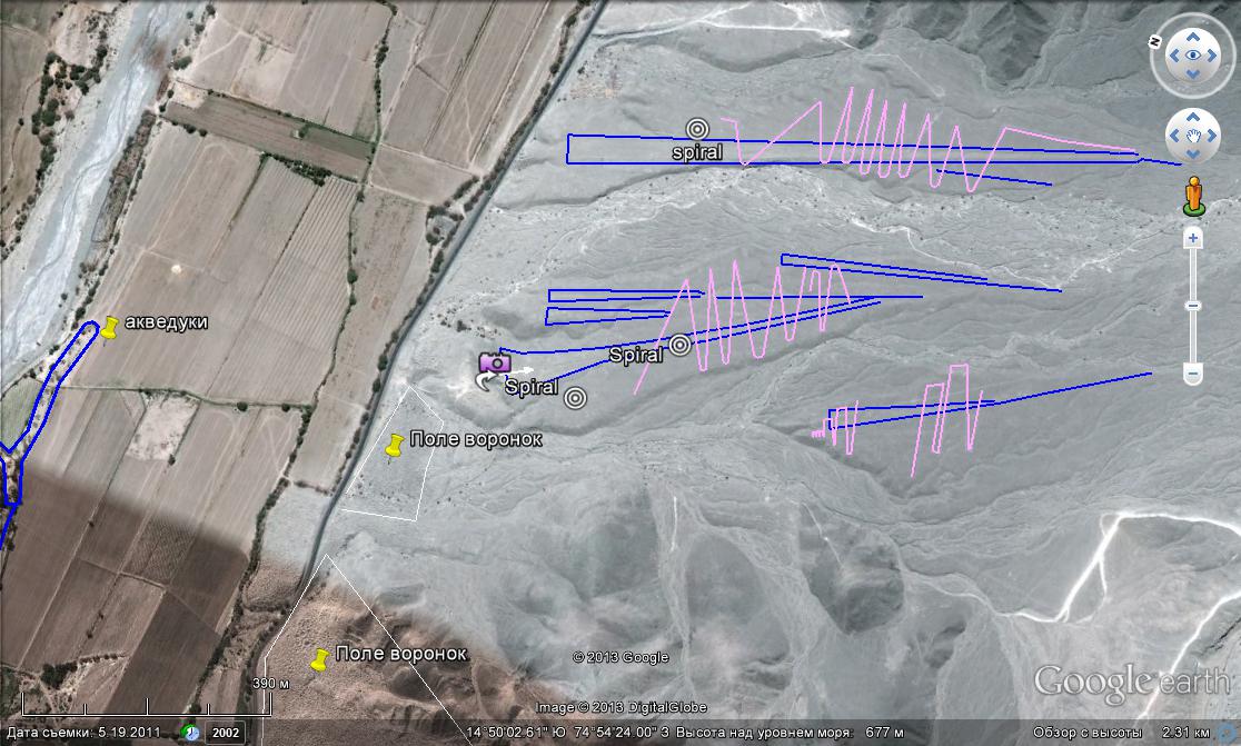
Figure 30. This is how this place looks from above. Attention: NORTH is on the left. There is the chain of aqueducts at the left side of the photo. Thin white lines contour the fields of conical depressions.
Figure 30 presents a close-up of the lower part of the valley. Here we can see three groups of wedges on three lower terraces which are separated by shallow arms of river with lots of dry riverbeds. The shape and location of wedges is similar to those that we have examined previously. The strike of the valley at this place is 320-330ºNW. Lines and wedges are arranged in the same direction. The latter, as usual, expand downstream. The length of the wedges is a few hundred meters. They reach the upper end of the terraces either with their peaks or an incoming line. This is where their surfaces almost get to the level of the riverbeds. Any water in the valley would flow into the wedges.
In Figure 30 we see both fragments and complete zigzag lines. They are marked with pink colour.
There is a well-preserved zigzag in the upper part of the photo. As well as a wedge it begins as a line running from the upper end of the terrace. What function might it have? The ditch of this configuration could both irrigate and dry some area, although such form does not seem optimal for the latter function. In order to do this, it would be preferrable to use a system of parallel ditches in the directions of the flow. Then the water would leave the territory faster. (NB: Despite the fact that the assumption of the need to drain water HERE might seem strange we must consider this version of the using of the lines as well. Even now, there are places along the valleys of the local rivers that require drainage.)
If you enlarges the image (Figure 31) you can see that the zigzag, which we perceived as a line-ditch, is not actually so narrow and presents a ribbon up to 5 m wide bordered by stone ramparts on both sides. Such width seems to be excessive for both amelioration and irrigation. But it becomes clear, if we assume that the water did not fill the whole ribbon but a small passage on its bottom. In some places its traces seem to be visible (Figure 31). The vagueness of its manifestations is due to the fact that on the territory freed of stones a lowering with sloping sides, not framed by ramparts, is just not noticeable.
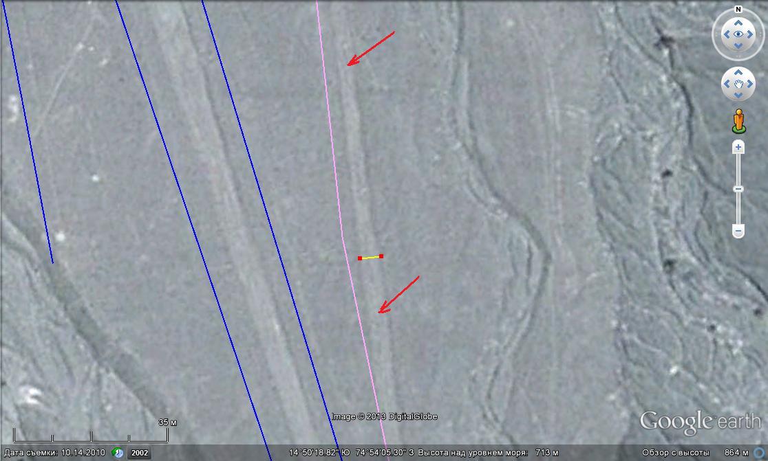
Figure 31. An enlarged view of a zigzag ribbon in its beginning. Its width (a section between two red points) is about 5 m. Red arrows indicate the traces of the passage along the axis of the ribbon.
Hence the conclusion that a zigzag-looking line is rather a narrow field organized along the irrigation channel. The zigzag lengthened the path of the water on the sloping surface of the terrace thereby increasing the irrigated area. The step of the zigzag (the distance between the nearest peaks) in this case could be conditioned by the surface tilt. The steeper the slope the more you could “squeeze” a zigzag, and the more compact it was, and easier to maintain. And on the contrary, the smoother the surface, the farther one had to to place the “knees” of zigzag from one another in order to provide the needed angle to the water flow.
Figures 30, 32 and 33 show that in the lower part before turning into a spiral the period of the zigzag sharply increases. Hence, it can be assumed that the surface here is becoming more horizontal, which is natural as you get closer to the mouth of the valley. The zigzag which is the closest to the west side behaves in the same way.
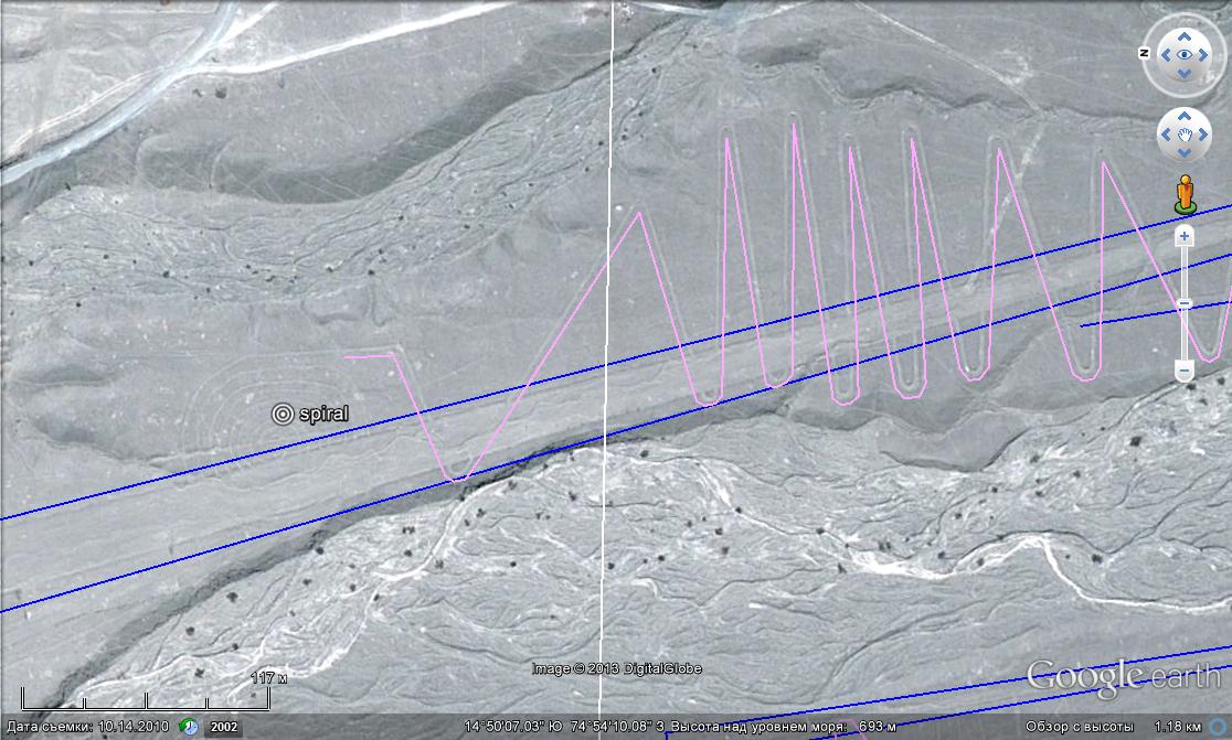
Figure 32. The transition of a zigzaginto a spiral. Attention: the north is on the left.
However, having made the last zigzag the line did not end but curved into a spiral. And, as in the previous case, this spiral is double. What caused such a strange ending of this zigzag?
Apart from its shape, the spiral has another important difference from a zigzag. It blocks the water flow, if it is located on an inclined surface. Liquid when running along its circles cannot go up the slope and then go down in a natural way. However, it can be filled with water on the horizontal plane. Any depression or any ditch of the most peculiar configuration would be filled with water this way, not only a spiral. Hence, we can assume that spirals mark the areas that used to be horizontal.
Having provided an opportunity of water discharge at the end of the spiral it is possible to avoid flooding in the case of excessive fluid intake. This is what distinguishes the advantage of a double spiral in comparison with a simple one. It allows water to circulate. Figure 32 shows that the western sides of the spiral are bordering with a depression. This is where the excesses of water could be discharged.
Now we will turn to the wedge which is located almost on the axis of the zigzag. An attempt to understand which of the figures was there earlier by means of studying their borders in the places of overlapping turns out to be unsuccessful . For some reason people did not want to make or continue the border in the places that were cleared of stones.
Look at Figure 33: the borders of the zigzag are nowhere built over the wedge. Similarly, at site of zigzag entry the breaks in the wedge boundaries are nowhere restored. It seems, it would not have been be difficult to restore them because of their small extent, but for some reason this was not done. It seems strange, especially if we assume that once there was water, and the absence of borders at the crossings would make water flow the wrong way. However, this seems strange only at first glance. If water did not fill the whole ribbon or wedge but only the ditches laid on the bottom, everything becomes clear. For the functioning of such systems the ditches are more important than borders. And in order to understand how different figures were overlapping, it is necessary to deal with ditches. It is harder but sometimes it is posiible even using satellite images.
In Figure 33 there are no traces of zigzag lines crossing the wedge. However, we can see lines going along the wedge. Sometimes even some later washouts are attached to them. In plan view they look like a step structure, as if jumping from one line to another. Hence it can be assumed that the wedge was imposed upon the zigzag. And as we shall see further, this corresponds to the logic of the relief development.
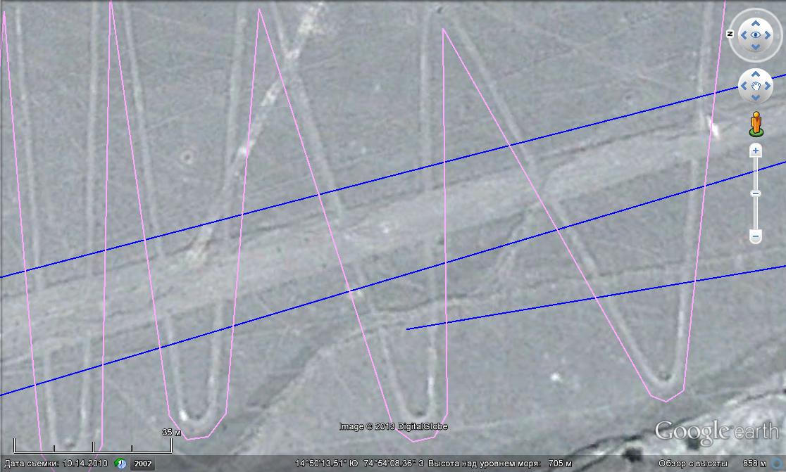
Figure 33. The absence of boundaries at the crossings of a zigzag and a wedge. One can see the traces of ditches along the wedge, which are sometimes intercepted by washouts. NB: Note some black spots which are in reality the piles of stones marking every turn of the line. In my opinion, they are the remains of landmarks that helped to mark the zigzag on the ground.
This is not the only place where we can see the absence of the geoglyph borders where the geoglyphs overlap with each other, which indicates the secondary role of the external frame.
Figure 34 presents a wedge with a regular shape formed due to ditches, and not to stone ramparts. The ditches are marked with blue lines. Stones collected during the cleanup of the territory are stacked in piles without much system and placed along the ditches, both inside and outside.
Figure 35 presents a wedge or a ribbon the shape of which can be mainly seen due to the piles of stones and light surface cleaned from them. It is mostly true about its NW border. It is marked with a red arrow. The piles are clearly arranged in rows which is most likely due to the presence of ditches. Here we can also see a feature that we had mentioned earlier − the top of the wedge is cut and there are two heaps at the entrance. They are marked with a red circle.
Wedges with boundaries marked by heaps of stones and wedges with heaps of stones collected inside are not so rare in Nazca. They easily coexist with "normal" wedges sometimes forming “intermediate” lines between those marked out previously. Sometimes heaps fill only a fragment of a ribbon or a wedge. An example of this is shown in Figure 36.
This picture shows a wedge of 10-15 m wide located on the narrow top of the ridge. An encircled part of the wedge is filled with heaps of stones. The rest of the area is cleared from the stones. The southern boundary of the wedge attracts the most attention. It is rough and has a fairly distinctive look. Some of its parts seem to be displaced in a parallel way into the wedge with a certain step making the wedge narrower. I think here we observe the process of expanding of the area of the wedge by building new ditches on the sides and gradual stone clearing from added territory. Such complex character of the external border once again confirms its secondary role. Inside the wedge one can clearly see longitudinal bands (it is marked with arrows). Zooming in allows to see about 6 or 7 of such bands, therefore, the width of the ridges amounts to about 1.5 m.
Figure 34. The heap of stones without any particular order are lined inside and outside of the wedge (red lines), the outer boundaries of which are represented by linear ditches (blue lines).
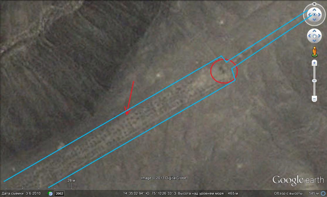
Figure 35. The shape is manifested by a lighter shade of the territory cleaned from stones and by the heaps of stones. The heaps are arranged in rows.
Figure 36. The wedge in the process of building boundaries. It is partially filled with piles of stones.
In this part of the chapter we talked a lot about the ditches within cleaned areas. Now it is the right time to see how they actually look. This can be done looking at Figures 37, 38, 39.
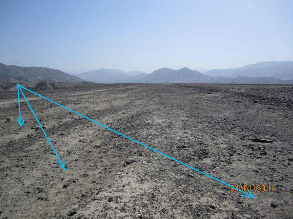
Figure 37. Ditches (dipressions) on the ribbon.
Figure 38. A ditch on the wedge (the ribbon). The area ofthe left bank of the Palpa River.
Figure 39. A ditch on the ribbon. The area of the right bank of the Palpa River.
Now we will go back again to the surrounding area of the city of Nazca, because besides lines and spirals there are some very interesting constructions here. At the exit of the valley that we have been discussing almost at the modern bed of Tierras Blancas (Figures 28 and 30) there is a series of wells-aqueducts or puquios made by an unknown persons and in unknown time (Figure 40). They are located in the left parts of the pictures and in both cases are marked.
Please note that this part of the valley at the confluence of the Tierras Blancas and the Ajo Rivers was expanded and is heavily used by farmers. This is a similar oasis to that in the vicinity of the village Estudiantes on the Ingenio River.
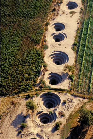
Figure 40. Puquios. Photo № 4407948 from Panoramio by Mylene d'Auriol.
All of these wells are connected underground by a single horizontal tunnel that was constructed in the aquifer at a depth of 5-6 m. This was done in order to increase the area of the filtering surface connected directly with the inflow of water. Further to the west, the tunnel exits onto the original ground and turns into a ditch lined with boulders, which goes toward the city of Nazca and supplies the fields and gardens with water.
The wells are functioning even today confirming that the location of wedges, lines and spirals in the above mentioned valley in the past was not accidental. Similar wells connected by the system of ditches exists in the city of Nazca itself and on the right bank of its valley, although they are not actively functioning nowadays.
In the low right corner of Figure 29 one can see a vast field with thousands of conical depressions that so far are viewed by archaeologists as ancient tombs which were looted. If so, then we have an ancient city cemetery near the city of Nazca.
Thus, studying geometric geoglyphs without using the most spectacular photos taken from aircrafts, but in some routine situations that are not very expressive, we found that they all have a connection to water. This connection is not indirect, rather very direct and close − the lines were water passages and the wedges were the users of water.
In the next chapter, we will study the nature of this water, where it came from, and whether it exists now.
| << Previous | Contents | Next >> |


