

To display the site correctly, please, enable JavaScript.
Chapter 3. Water in Nazca
| << Previous | Contents | Next >> |
The issue of water in Nazca, in my opinion, is the key issue to understanding of the purpose and special features of the objects of our study.
General information on water in the region is as follows. In the mountainous part of the Rio Grande basin it rains from December to March. In the coastal area there are almost no rains. The amount of precipitations increases with altitude reaching 500 mm at elevations higher than 4000 m.
Most of the water is supplied to the region by rivers originating in the Andes. Usually they come to life in January. But the water reaches the plains not every year and not from every river. Although sometimes the reverse happens: the water overflows the riverbeds which leads to floods. One of them caused great damage to the city of Nazca in the 1980s.
Naturally, there are some groundwaters in the region. Most of them are connected with river valleys where many holes have been made. The water from these holes is used to water the fields. Along the way, swamps get drained and new plots get involved in the crop rotation. In Nazca itself, alongside with holes, wells are also used to supply the city with water. We have seen one of them in the courtyard of Victoria. There was only 5-6 m from the ground to the surface of water. Back then I did not pay much attention to this fact, although I should have, because it was the beginning of January, the end of the dry season and rains in the mountains had not started yet. However, living in Nazca for more than a week we did not notice any problems with water supply. Restaurants were working, pools were full, and the tap water was always good.
Now we will turn to the results of our work. Watching geoglyphs we constantly saw many traces of watercourses both on and around them. Naturally, the question about the source of water arose.
Despite the fact that there was no rain in Nazca for a few decades, the possibility of showers here did not seem impossible. Every night during our stay there the mountains got clouded, it became steamy and we had a feeling that the drops of rain would fall any minute. On the last evening waiting for the bus to Cuzco we even had a chance to see a few drops fell on the asphalt. The probability of rain was intensified by the fact that Peru is in the zone of El Niño − risingto the ocean surface of cold Antarctic waters, a phenomenon that can unpredictably influence the weather.
As I wrote before, a standard view concerning dry riverbed in the desert connects them with showers that took place some time after creating the lines. Why after? Because geoglyphs in the desert are almost everywhere cut by these riverbeds.
One of the most important results of our short observations in the mountains was that we came to the understanding of a fundamental thing: the geoglyphs were created precisely during the time of water abundance. We saw that in shallow valleys cut be washouts people tried to set wedges in such a way so that the flowing water would not affect them. This proved that the floods were expected, hence, we can talk about the period of water abundance rather than about occasional showers. Such view allows to look at geoglyphs and their purpose in a fundamentally different way.
Another thing is that this period overlapped with the period of the creation of geoglyphs, that is why they are often damaged by washouts and after that they were not restored. But this does not add anything to their “lifetime stories”.
In the process of interpretation of the results of the routes another version was born and began to settle: the origin of the water eroding the surface of the desert was not meteoric (rains, showers) but rather underground. Getting familiar with existing data only confirmed this assumption. Such conclusion, though it seemed unreal at first, brought clarity to many features of the structure and location of the geoglyphs.
Let us consider all “pros” and “cons” of both versions and also try to understand whether there are at least any evidence in the region now suggesting that in the past water could flows out of the ground. I want to emphasize that we are interested not just in ground waters that can be found everywhere, although do not manifest their presence everywhere. We are interested in underground pressure water capable of flowing onto the surface continuously or periodically. The closest analogue is not geysers but ordinary artesian waters that are extremely widespread on the planet. It is enough to recall the Great Artesian Basin in Australia and the West Siberian Plain in Asia.
Facts supportinf the rainwater version include the following. Firstly, there are lots of washouts in the region. Secondly, there are traces of water courses in almost every lowering in the mountains. In the bottom of each, even the smallest ravine, cleft, or valley you can find alluviation of gravel, sand, light clays or, on the contrary, cleansed of sediment rock surface slightly smoothed over by debris that was once being dragged over it.
Factors testifying against the rain version include the fact that even in the immediate environment of the desert one can find land areas not less than 1 hectare with no traces of watercourses in the sand. I naturally excluded the places on which modern wind deposits are developed and those that present recently raised seabeds. It is clear that the dunes could hide any traces of rain, and the digression of the sea could happen just recently. The shore here is very mobile, both ways.
Since there is nothing to show on these sites I included the photo of the first one only (Figure 1) and provide the coordinates of the centers of some of them. Those who willget interested will be able to use this information.
1. 14о52’ 57.64”S 75o22’37.01”W h=95m
2. 14о53’ 17.12” S 75o21’08.65”W h=607m
3. 14о54’ 35.10” S 75o23’58.38”W h=249m
4. 14о55’ 26.63” S 75o24’36.53”W h=65m
5. 14о57’ 44.21” S 75o26’36.21”W h=355m
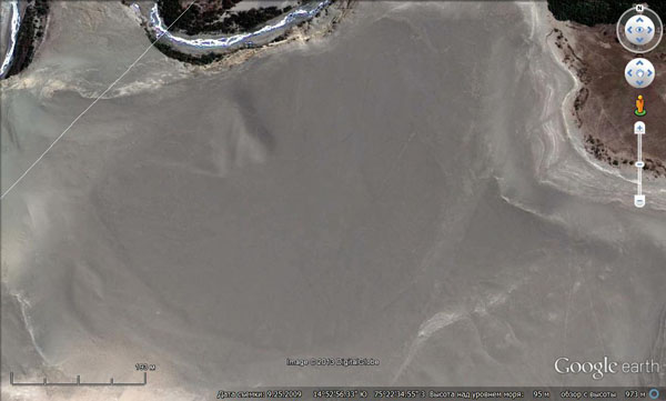
Figure 1. Site 1 without traces of the hydrographic network.
Figure 2 shows a site of the north of Nazca with traces of hydrographic network. For the purposes of comparison both are photographed from roughly the same height.
This comparison is not flawless because one must take into account the permeability of the surface deposits and the sloping of the territory, but the differences seem to be striking, although in both cases there are sand covers.
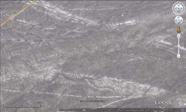
Figure 2. The site in the north of Nazca with traces of stream flows.
The lack of washouts caused by showers is also showed in the pictures of hills made of marine clays and located between Nazca and Ica (Figures 3 and 4).
Figure 4 shows that deposits are very fragile as they form hardly any debris. Had there been showers there would have been traces of water flows. Since we do not find them, then, most likely, there were no rainfalls. Therefore, the washouts in Nazca and surrounding mountains are of different nature. We should not go to extremes and assume that there were no rains in the region at all. They could take place, and most probably they did, however, they did not have very noticeable effects.
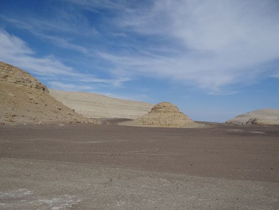
Figure 3. The hills without traces of water erosion on the slopes. Panoramio № 68121795.
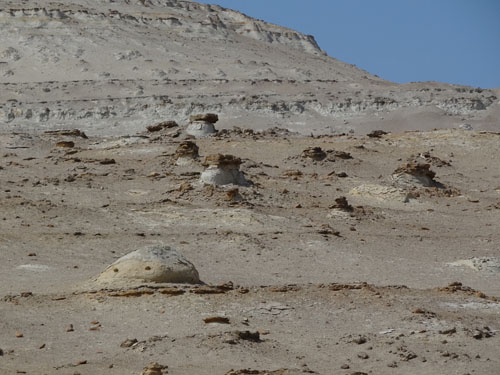
Figure 4. A hillside without traces of water erosion nearby. Panoramio № 68122064.
NB: Looking at these photos I can not help alluding to the issue of the relief formation.
In my opinion, the morphology and appearance of the hills shown in Figures 3 and 4 confirm my thesis that not only mountainous countries, but also some separate forms of relief could grow. I can almost see how at first in the shallow coastal bay a shelf appears, which gradually turns into a small island. It is easily washed out by waves, because it is made of clays, but it grows and increases in size. The waves wash away its sea-floor sediments and reveal its internal structure, both hard and soft layers of sediments, causing its surface to acquires a wonderful view. The products of erosionare carried away by water. At the same time due to the growth of the Andes the bay itself gets more shallow. In the end the bay gets completely drained and former islands become solitary hills. Their expressive forms look paradoxically against the smooth field of what used to be the seabed. Now these bumps become traps for aeolian sand and it is possible that they are still growing.
A similar kind of formations though made of rocks with some slides along the perimeter are abundant in the Sahara desert between Aswan and Abu Simbel. This is another desert that used to be a shallow bay in the recent past. In hot weather those formations that are closer to the horizon seem to turn into islands surrounded by boundless sea. This happens due to optical effects over the hot surface of the desert. So, the past, though in the form of a mirage, reminds of itself.
An argument against the rainy origin of water is a mismatch between the size of one of the valleys and the quantity and size of the washouts there that was noticed in the first route. However, the assessment of this mismatch is a rather objective thing.
Now let us proceed to consider the second version stating that the water supply is associated with gushing springs.
As I wrote, during our first route my attention was caught by strange bright spots at the places where surface deposits changed their composition. The diameter of the spots reached several meters, and they were mostly composed of silty unbound material (Figure 5). Within the spots coarse-grained material was distributed unevenly. There was more of this material towards the edges. It was not because the fragments were covered with light powder. Stones on the surface were fewer indeed.
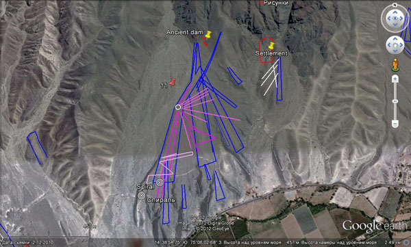
Figure 5.
At first I thought that someone used to dig there and then the hole was filled. This conclusion was made under the impression that on some spots there were traces of excavation. But in the subsequent routes it turned out that the spots were numerous and most of them bore no traces of human activity. Their surface was faultless and smooth and did not stand out above the surrounding level. The abundance of spots was confirmed by photos from Google as well. They were especially numerous in the northeastern corner of Nazca, where the maximum amount of geoglyphs is concentrated (Figure 6).
Figure 6. Bright spots in the north of Nazca.
I did not dare to dig the spots that I came across with because I did not want any problems with the local authorities, but I wanted to see what was inside of them.
The occasion came in due time. Climbing to 100 m plateau on the left bank of the valley shared by the Palpa and the Vizcas rivers, at the foot of which San Ignacio village is located we found ourselves surrounded by a variety of lines and ribbons (Figure 7). Their concentration was unusually high. However, the horizontal nature of the surface did not allow to make any conclusions with regard to their connection with water. Among all these graphics we saw both big and small light spots. They can be seen in Figure 7. Someone tried to dig one of them (Figure 8). When studying the debris around the hole, we found out that most of it was not similar to that on the surface around. It was presented by almost white pieces of light, porous, breakable material like travertine with some amount of small fragments of the surrounding rocks. This material easily turned into very light dust of the same kind, from which I drew it. I could not help digging a hole by hand for about half a meter. Bright dust was there as well and I did not get to the bottom, but in the board of the hole I discovered a 10 cm layer of the above-mentioned porous material similar to tuff. I took a sample of it.
In a small outcrop, where the plateau surface ends and it starts sloping, I was able to see another spot of the same kind in section for about 1 m deep. Below the fragment was covered by cliff debris.
The analysis of the samples in St. Petersburg showed that pieces of both porous and dusty material consist of clay, calcium carbonate and sand. The main difference lies only in the fact that some were loose while others were slightly cemented.
Pondering possible options of the origin of the spots I came to a conclusion that this is the way underwater springs could look. It is known that they exist not only on surface, but also in the bottom of water bodies. In this case groundwater made their way through the unconsolidated bottom sediments bringing with them carbonate and clay taken along the way from the surrounding rocks. Limestones are extremely widespread in the region.
Figure 7. Bright spots on the surface of the desert.
However, one might ask why we do not see feeding channels inside the spots, along which the groundwater was flowing from below. Their presence would immediately indicate the presense of a spring. I think the reason is that the spring water was flowing through unconsolidated sediments. In mining-and-processing technology such conditions are called a "fluidized bed” or “boiling bed”. The only thing it has in common with boiling is that in the process of water raising from below the sediment particles, like it is when we cook cereal, are set in motion and, as a result, get separated by their fall diameter. Heavier and more compact ones begin to fall down, while lighter and more flatter ones get forced upward. Thus, the fragments of rocks that once lay on the bottom surface sank deeper and their place was taken by lighter and smaller carbonate particles and sand. The most intensive process of separating particles by their fall diameter took place in the central part of the spot where a mainstream was. That is why it was there that large fragments were the fewest. Carbonate-clayey material brought by springs did not form bumps on the bottom of the reservoir, because it was immediately washed away by waves and scattered around filling a void in coarse-grained sediments (remember breakstone with light dust in the first route).
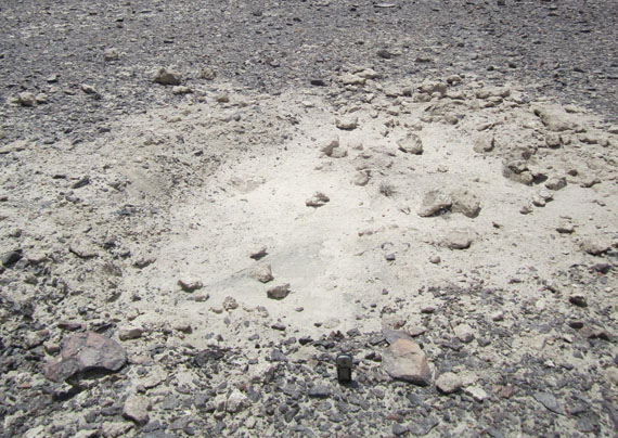
Figure 8. Bright spot on the left plateau near Palpa.
After draining of the plain the springs continued to function but groundwaters could spread around in the mass of unconsolidated sediments without flowing to the surface. Such places could be indicated due to damp sand, the presence of puddles, and acquired an unpleasant quality of catching people, that is, became quicksands. During the same period of time near the places of groundwater outflow the aggregation (lithofication) of deposit could occur. Interlayers and lenses of something like tuff, the fragments of which I have described, could be formed. The draining of the territory could contribute to that process. Together with the retreat of the sea and water disappearance the stability of the conditions for sediment presence was gone as well. It could alternatevely get filled with water or dry out, and this could lead to its lithofication as it happened on Malta.
Apparently, some springs came to the surface. One of them is possibly presented in Figure 9 on the plateau on the right bank of the Palpa. Along the perimeter it is laid by stones. A hole is made in the center from which it was convenient to draw water. There are many bright spots around indicating an abundance of places of the outflow of groundwaters.
Stones from the mountains were brought by people to make this place less muddy. The thing is that the covering deposits on this part of the plateau are almost entirely represented by silty carbonate-clay material, which is likely to turn into mud in the area with lots of water.
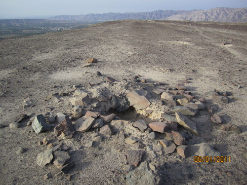
Figure 9. Remains of an ancient spring (?).
It is interesting that at the foot of the plateau from the direction of Palpa we were shown a functioning spring. The flow − around a few tens of liters per second − forms a stream descending through the thicket of bougainvillaea into the valley. This manifestation of pressure water is called de Santo Domingo de La Maquina spring.
However, there were some other things besides white spots that gave me the idea of water sources.
On the plateaus near Palpa on the way to the remains of the ancient settlement of Pinchango Alto I saw an interesting picture. At the top of a small calcareous hill I found a small hole laid with stones (Figure 10). Two lines (ditches) started from it to the north and south-west. They are visible in Figure 11. The line going southwest is indicated by arrows in the first picture. From this point you can see well how it goes down into a small valley and then up onto the plains located slightly below the hill.
The fact that this top was not quite usual could be seen from afar − its rocks bore the traces of ferrugination. This is evident even in the picture − many pieces of rock have brownish color. Studies in St. Petersburg showed that the rocks are limestone and that along with ferrugination they bear some traces of dissolution and authigenic calcitization (i.e. the formation of calcite under the conditions of daylight surface). Some voids were filled with clay. All this pointed to the fact that in the past there could be low-temperature thermal springs there. By the way, the average temperature of groundwater in the lower reaches of Nazca-Rio Grande according to the measurements by D.Johnson is 25-30ºC. Water of such temperature can be already considered as low-temperature thermal springs.
The water was diverted to the areas of consumption by means of ditches. The fact that the ditch first went downhill into a small valley and then went up the plateau did not bother me. I allowed that the lowering which we called the valley could be newly formed and could have tectonic nature. Previously, the surface could be united, not dissected, and the hill could barely rise above it.
Such top is a miniature analogue of well known Centrpoints in the Nazca Desert, which we mentioned earlier. The difference is that this hill is smaller and there are only two radiating lines.
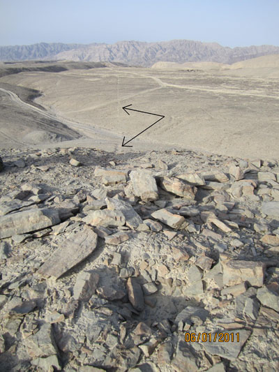
Figure 10. A supposed spring on the top of the hill and the ditch going southwest.
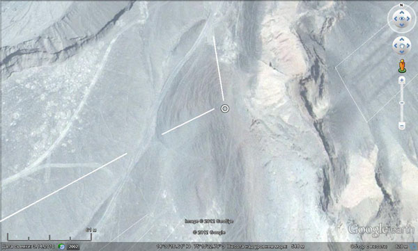
Figure 11. A crater is marked with a circle in the center of the picture. The line marked with an arrows in the top picture is shown here in the bottom left quarter of the photo. Besides, pay attention to the hillside. They bear traces of terracing.If my assumption is correct they are the traces of its upward growth.
On our route in the desert to the south of Cahuachi we got to another Centrpoint from which a few lines and ribbons started including the most significant ribbon in this part of the desert ending after 1.5 km with a large wedge. The top view of this place is presented in Figure 12. The view from the ground is presented in Figure 13.
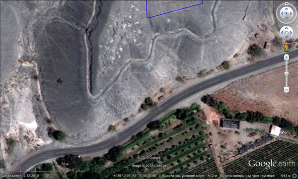
Figure 12. Centrpoint in the desert to the south of Cahuachi.
Whitish alluviations on the ribbon itself and near it on the hill stands out (Figures 12 and 13). The thickness of a loose layer here is not significant. Bedrocks go directly to the surface, it is to these places that silt alluviations tend to be drawn to. Most likely, it is the traces of groundwaters with light silty carbonate that used to flow out of the hill.

Figure 13. View from Centrpoint to the ribbon.
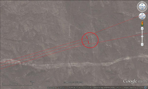
Figure 14. The end of the ribbon with a ditch that can be seen along its axis. Instead of the usual heaps the top of the wedge is blocked by two stone walls. Its width in this place is about 40 m.
NB: Please note that in the lower half of the picture there is a light band of differring width. In my opinion, it is an ancient path to the lower reaches of the river. Its old age is confirmed by the fact that, like the geoglyphs, it is cut by dry riverbeds. Its lighter tone is created by feet of people who disturbed “desert tan” on the sand. Such paths near the geoglyphs are numerous in the area, one just has to learn to distinguish them from the modern ones.
Below there is a photograph of one of the Centrs in the desert made by Erich von Daniken from the plane. One can clearly see there a black hole, which could be a supplying channel of the spring, from which diverging lines were being fed. Neither Daniken nor I could get close and look into it − it is located in the area of the archaeological reserve. But I think that some people surely did it. It would be interesting to know what they saw.
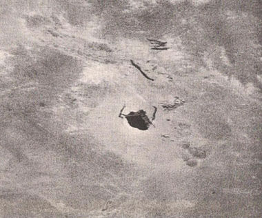
Figure 15. A hole in the desert. Photo by Erich von Daniken from the book Arrival of the Gods: Revealing the Alien Landing Sites of Nazca.
Unfortunately, it is hard to spot such holes in the GE pictures − they are too small. However, most of similar places are visible in the pictures due to the presence of light aureole and stone piles.
Another evidence, this time a modern one, of the emergence of water of unknown origin is the dams protecting the highway to Cuzco. They are located in the low part of a small valley, the upper parts of which begins at the foot of Cerro Blanco 7 km away from the town of Nazca (Figure 16).
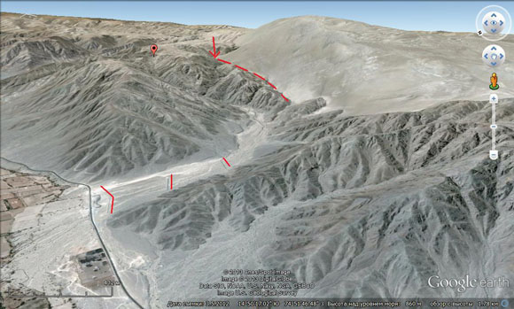
Figure 16. Dams protecting the highway in Cuzco. Red marks designate the upper parts of the valley. A light gray mountain in the upper right part of the picture is Cerro Blanco.
In Figure 16 one can see that the upper reaches of the valley start right on the border of sands and bedrock and that there are three dams in the valley designed not to block it but to redirect water towards the left side.
Can we assume that they were built not on the basis of some negative experience but just in case? I think, this is unlikely. But how could water appear in the valley except out of Cerro Blanco if we take into account that the entire length of the valey is only 10 km and it does not reach the zone of rain for tens of kilometers.
The next valley, as we go down, also starts at the foot of Cerro Blanco and is located almost at the city of Nazca. We have described its geoglyphs. There are no dams there, but there is a chain puquios (aqueducts) at its mouth, which supplies nearby fields with water.
All these facts add something misterious to White Mountain − this local attraction, which some people mistakenly take for the biggest dune in the world.
The presence of pressure water in the region confirm the results of the search of oases using satellite photographs from GE.
In Figure 16 one can see three small shrubby forests at an altitude of 600 to 700 m near the mouth of the Acari river. The height of the elevation itself (1500 m) and the surrounding relief excludes the possibility of water inflow due to regular water runoff from the Andes highlands.
The inflow of water can occur only from the bottom. And indeed, this mountain is connected with the Andes by a mountain ridge, which can be a conductor of underground waters.
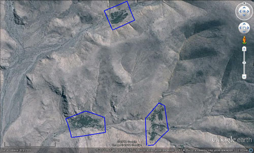
Figure 17. Oases in the heads of dry valleys near the mouth of the Acari.
Figure 17 shows a view of the oasis callws “Lago Uachachina” near Ica. There, on the right bank of the river there are a few lakes like this one. Their height above the sea level is about 400 m.
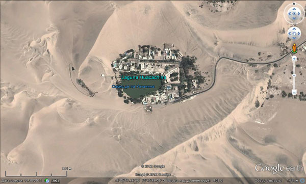
Figure 18. Uachachina Oasis (Ica).
And the last major discovery is so called “Hills of Atiquipa” (Lomas de Atiquipa). They are located on the shores of the Pacific Ocean, 100 km to the south of Nazka.
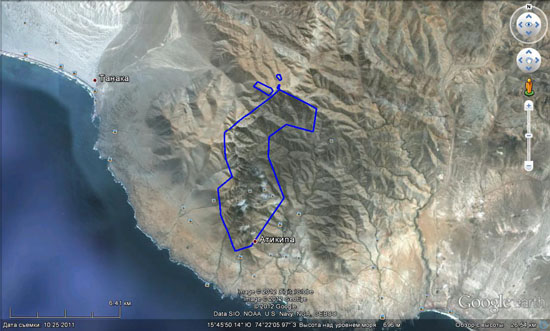
Figure 19. The reservation Lomas de Atiquipa. The oasis itself is circled by a blue line.
Water well-being of this oasis is explained by its microclimate caused by clouds that often get caught on this mountain. But I think this is also caused by the influx of pressure water. The height of the mountain within the area of the reserve is under a kilometer, and it is not particularly different from other elevations in the vicinity. However, the tops of the nearby mountains are deserted. It is hard to believe that the clouds are able to shed water so precisely on some areas while leaving others dry. Moreover, like the previous mountain, this one is a spur of the Andes.
Now we will turn to the published data and see whether there is anything there telling about the presence of pressure waters.
In the book written by Helaine Silverman “Cahuachi in the Ancient Nasca World”, in the chapter “Physical conditions” the author referring to the data provided by ONERN (Oficina Nacional de Evaluacion de Recursos Naturales (Spanish: Office of National Assessment of Natural Resources; Peru) writes that “crops do not always die in the valleys of the rivers Grande, Ingenio, Palpa, Viscas, and Nazca although droughts can be frequent and severe. Besides, the irregularity and low water level of the region's rivers as well as the barrenness of the surrounding plains and hills are not very consistent with the abundance of some parts of the valleys.” I think it may indicate additional watering of these places due to confined groundwaters.
In the section dedicated to groundwater the the author informs that in the area of the town of Nazka groundwaters wereintensively used for centuries (meaning the very aqueducts, which we have already mentioned).
Erich von Daniken in his book “Mysterious Nazca drawings” («Zeichen fur die Ewigkeit. Die Botschaft von Nazka», 1999) also writes about these constructions. He uses their local namer “puquios” and notes that the water there was fresh and clean − unlike dirty and smelly water from the Nazca river. I would like to add that its channel in the city does not look very nice, indeed, due to garbage dumps made in it.
Right there Daniken retells a local Indian myth that under Cerro Blanco mountain, which is located near the town of Nazca, and from the foot of which several small tributaries of the river originate, there is a huge underground lake, from which water supposedly gets into the above mentioned aqueducts. Besides, Indians are owing this to the creator god Viracocha who during a great drought and famine in response to the moaning and begging of people created this underground reservoir and the system of channels.
I doubt the existence of some large underground chamber, in which water is quietly splashing or flowing in the dark − this is the way people usually picture underground lakes and rivers. However, the theory that at the base of the mountain there are cracks through which moisture comes from the depths to the surface seems very plausible. In fact, water exists in the mountain, and it is proved by aqueducts, modern dams, wet holes drilled at its foot as well as fragmented scraggy vegetation tending to grow at the boundary between the sands of the top and the bedrock of the foundation.
In this myth the mountain Cerro Blanco appears as a kind of a shrine associated with the coming of the god Viracocha, a kind of a sacred symbol. This tradition picked archaeologists’ interst. Indeed, they had to explain somehow why it was here, not the best place for human life, the ancient Nazca culture was born and flourished. Moreover, the whole desert is covered by strange lines and drawings, which confuse serious and respectable scientists.
Extending, though with minor amendments, modern climate conditions and modern landscapes over past centuries archaeologists cannot understand why this poor region could become so attractive to ancient people.
Helaine Silverman also writes that in comparison with rich northern valleys of the Peruvian coast the river system Rio Grande−Nazca is poor. Rather small and low quality land as well as water shortage could not lead to the appearance of a more or less significant secular state and, as a result, there were no conditions for extensive construction. The area, due to its poverty, could not be of any long-term interest even for conquerors.
However, the banks of the Nazca were inhabited by mysterious Cahuachi stretching for miles, who were studied by Silverman herself. Besides, there are many ancient tombs with fine samples of textiles and various ceramics indicating a long and fruitful stay of people in these places. Finally there are ill-fated geoglyphs. Therefore, the assumption that the area could have religious, not material, interest for the ancient people was to be expected. Then all of the paradox of the situation could be explained by the specificity of the ancient cult, especially since there is a myth about the sacred mountain Cerro Blanco.
From the book Silverman we also find out that approximately 5 km east of the city (i.e. upstream) the water in the channel of the Nazca disappears and appears again only 10 km west of the city and such phenomena are not unique in the valley. At the same time, in many places in the valley of the river (Corralones, Mancha Verde, Estaqueria Alta, Estaqueria Baja, Jumana, and Cahuachi) one can observe the outflows of groundwater. Is it the same water that went under the ground upstream or some other deep water, I cannot say. But in Cahuachi the source from which people take water for drinking is located above the river level and it is permanent. Therefore, most likely, it is not connected to the river.
Silverman writes about another curious feature of the Nazca river. It turns out that not so long ago its valley opposite Cahuachi was flooded to such an extent that it became a marsh overgrown with reeds and thickets of willow and acacia. Only the massive use of downhole pumps made it possible to lower the groundwater level now and to engage additional land for agricultural purposes. Can there be a swamp in the middle of one of the driest deserts in the world without water supply? I think, this is a rhetorical question. Another source of information on groundwaters in the area is the following sites: http://www.eggi.com/ken/peru/index.html, www.people.umass.edu/proulx/index.html. The contain the information about the research of the Nazca basin by an American archaeologist David Johnson.
D. Johnson suggested a new hypothesis explaining the geoglyphs based on the spatial correlation allegedly seen by him between the position of the lines, archaeological sites, the most high-yield wells, wells, and the parts of the valleys crossed by geological faults. In other words, he was the first to suggest that the geoglyphs and other archaeological sites are associated with groundwater coming from geological faults, that still provides water wellbeing in the area.
Up to that point a prevailing concept was that the underground waters here were the direct results of river waters flowing down from the mountains. Hence, they should begin to form only after the appearance of water in the channels with the beginning of the rainy season in mountains. However, groundwater movement is slower than that on the surface. They penetrate the soil slowly, they are flowing slowly there, but they disappear slowly too. It can be theoretically assumed that in some places, under the thick layer of sediments they live to see a new flood. In such situation it is not easy to identify alternative sources of water, if they do not differ in chemical composition.
Studying the mode of water return and the productivity of different holes and wells Johnson noticed that near the town of Nazca the water level near the sides of the valley in some of the most productive holes was significantly higher than in the holes near the channel.
Author's note: In humid areas, such situation is perfectly normal because rainwater flows to valley not only from the upper parts of the river but also from the slopes. But here in the desert with no rain where the slopes do not collect anything the water entering the soil from the bed must reach the sides of the valley in the last turn and the groundwater surface must be lower, raher than higher.
But for some reason it was in such places that the ancient aqueducts were located in which after the start of the rainy season water often appeared earlier than in the mainstream of the Nazca. This led him to believe that the sides of the valley must have groundwater sources and that they are connected with faults.
Such structures here, according to Johnson, must be numerous, because the Nazca region as well as the entire western coast of South America is located in one of the most active seismic zones of the world. Given the shortage of water that existed, as he thought, even in the ancient times, it would seem logical if the people had settled in the valleys near these faults that represented a steadier and more reliable source of water than the river itself. He offered to view the geoglyphs which are plentiful on such sites as signs showing the path and direction of the groundwater flow. Accordingly, the combination of geoglyphs can be perceived as a kind of a map like the ones that exist in any city with underground pipeline.
In 1996, Johnson with a group of associates began his work in Nazca in order to verify his hypothesis. In the course of these studies in the river valleys and with usage of satellite and aerial photographs he allocated lots of lineaments (narrow rectilinear structures that geologists normally identify with breaks), made route observations to confirm them afield, took and analyzed many water samples and drilled exploratory holes to see if there was water. высокодоходный
However, according to Professor of Anthropology at the University of Massachusetts Donald A. Proulx, the results of testing Jackson’s hypothesis were not as optimistic as we would like. Geologists who participated in the works − Steven Mabee and Gregory Smith (Smith, Gregory 2003. Drawing Lines in the Sand. Analysis of Faults and Lineaments and Their Relationship to the Lines of Nasca) − having independently conducted a comparative analysis of spatial relationship of geoglyphs to faults, archaeological sites, high-yielding wells, and aqueducts concluded that the correlation is not significant enough . I.e. the cases when their location matches on which Johnson built his hypothesis are random, and not regular. Nevertheless, researchers often did think that the location of geoglyphs clearly indicates their relationship with water.
Johnson did not agree with these conclusions arguing that not all factors had been taken into consideration.
Donald Proulx (www.people.umass.edu/proulx/index.html) writes that there are many controversial aspects in this project, one of which is the original commitment of Johnson to the method of biolocation in search of groundwater. Nevertheless, we must give credit to him. The studies yielded many new and interesting data on hydrogeology of the Nazca basin. Besides, there have been found previously unknown geoglyphs. It was also found out that some tributaries of the Nazca supply it with water through intermediate collectors (gravels and sands) meaning, first of all, aqueducts, which collected water from galleries of filtering. Chemical analysis showed that the mineralization of the water is weak almost everywhere, which means that it has ageoglyphs. meteoric (rainy) and not deep-seated origin. Therefore they associated the appearance of water in aqueducts with rare but heavy rains at lower altitude levels in the mountains. This conclusion, in my opinion, is rather strange because such rins are rare while the presence of water in aqueducts is characterised with lenght and stability.
The ambiguous results of works, in my opinion, were predictable. Nevertheless, I think that Johnson is rights in both his assumption concerning another source of water and its connection with tectonic zones. The fact is that in the basin Nazca-Rio-Grande faults and geoglyphs much more numerous than oases and wet holes. Therefore one should not have expected high spatial correlation.
Unfortunately, neither Johnson nor geologists who worked with him considered the possibility of geological changes in the region that after the creation of geoglyphs, that radically changed everything around. Had they known that only a few thousand years ago the process of mountain building took place they would have already solved the mystery of lines.
Summarizing everything above-mentioned, we can conclude that the presence of pressure water in the region nowadays can be proved by a number of facts. And these water, as Johnson discovered, are mostly fresh, which indicates their surface origin. Their nature, in my opinion, can be no other than artesian. Andean highlands abundantly irrigated by rain and flat foothills stretching into the sea present a classic pair − feeding zone and unloading zone. The closeness of their location (catchment areas begin a few dozen kilometers away from Nazca) caused depthless water downwelling. Therefore, it is poorly mineralized and not hot. In the Great Artesian Basin in Australia the feeding zone (Great Dividing Range) is located hundreds of kilometers away from unloading area. Water goes down for miles there and, naturally, comes up to the surface hot and salty.
One can wonder only about the fact that it is so poorly manifested nowadays. It would seem that after the process of mountain building the mountains grew higher, hence, it should rain more which lead to greater anounts of groundwater. Nazca should bathe in water by now, and fountains should spout of all old springs supported by the water column of 3 kilometers tall. However, we do not see any of this.
I think, there are a few reasons. First, the growth of mountains and the Nazca plain by hundreds of meters up led to the removal from the ground-water table. Before the restruction it was at a depth of a few meters, after the restructuring it lowered by dozens of meters. The inflow and water pressure was no longer strong enough to get through this formation. Maximum it can do is to feed valley fill from the bottom.
The second possible reason of the reducing of the inflow of artesian water is that the compartmentalization of the relief after the restructuring led to the acceleration of run-off over the surface through streams. Nowadays meteoric water flows into valleys and into the sea much faster than at the time when the relief was lower and flatter. In those conditions water stayed on the surface for a long time turning all around into swamp and finally soaking into the ground. Paradoxically, the most ancient settlements in mountainous parts of the Andes were not confined to river valleys, as they are now, but rather to the tops of sloping hills and watersheds − the areas which were less prone to the formation of marshes.
The third reason is that in the process of mountain building countless faultings were involved. Drifting along these fauls could disturb the continuity of the aquifers and cause the closing of the system that had been formed during the period of stability of karst cavities and channels through which groundwater used to reach unloading areas faster than surface water.
Thus, in the process of the reorganization of the relief the role of groundwater decreased repeatedly and the Nazca plain started turning into a desert.
| << Previous | Contents | Next >> |


