

To display the site correctly, please, enable JavaScript.
Chapter 5. The mechanism of relief formation
| << Previous | Contents | Next >> |
This chapter is especially interesting for those who want to get a general idea concerning the effects of lateral compression upon geological mass near the surface.
This process, when compression is increasing, is presented in the diagrams in Figure 1 showing the fundamental development of the relief.
Stage 1. Plain. No folded structures are visible, but they may exist. Side compression is present, but its role is secondary compared to the factors that flatten out the surface (for example, waves). This is a period of rest.
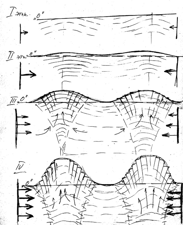
Figure 1.
Stage 2. Compression is increasing and the factors flattening out the surface do not have time to deal with the deformation of the surface. Folded structures begin to appear or emerge, if they did not exist till this time.
Stage 3. Compression is increasing, the deformation of the surface is increasing too, but so far everything is limited to plastic deformations.
Stage 4. Compression reaches a critical level, the deformation structures reach their maximum amplitudes and are complicated by faults, developing from the surface downwards and fading there. The slopes affected by numerous faults might have acquired stepped character, formed rocky ledges, and got covered by talus. Larger faults might have caused the formation of terraces.
Any geological objects captured in the field of compression could trigger the formation of deformation structures around themselves or get deformed themselves. Intrusions, dikes, wide lodes, and volcanic vents characterized by high stiffness were usually squeezed out and thus appeared in the relief more vividly. This reminds the process ofsqueezing a splinter out of the finger.
Figures 2-5 show characteristic stepping of the slopes, which, in my opinion, illustrates the presented mechanism of the growing (becoming more contrast) of the relief.
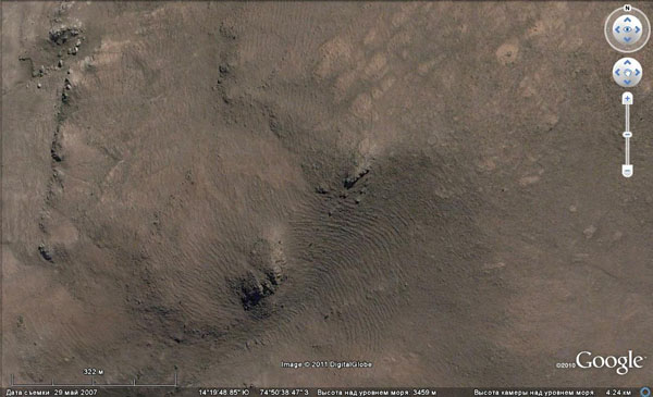
Figure 2. Tectonic step structure of the slopes. Upper reaches of the Andes.
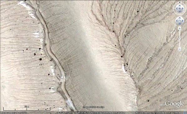
Figure 3. Step structure in limestone.
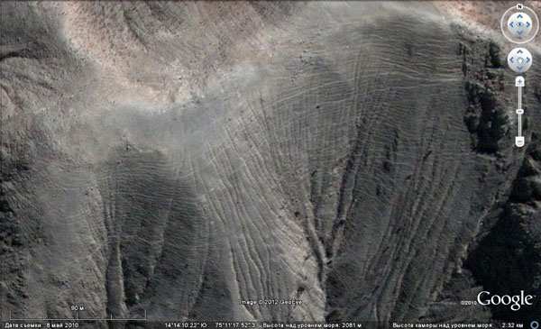
Figure 4. Step structure of the slopes in the upper reaches of the Andes.
Unfortunately, I was not able to visit all three sites shown in Figures 2, 3, 4, and many other similar ones and ascertain myself that these terraces were natural ones. I am 99% sure in his conclusion, but there is still one percent that I was wrong.
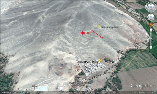
Figure 5. Step structure of the slopes near the town of Palpa. The arrow indicates the place where the photographs were taken.
Figure 5 shows the slope of the 100-meter high ridge in the suburbs of Palpa, near the local cemetery. I was able to go there and inspect the slope closely enough.
This stepping may seem to be the manifestation of geological stratification. However, it is not so. Hillsides are covered with a layer of unconsolidated sand and gravel deposits, which do not allow to see the outcrops. The very existence of such a cover consisting of modern coastal sediments, being developed from the ground up to a hundred-meter peak, may already indicate that this could not happen without tectonical activirty.
Figures 6 and 7 show how these steps look near. The place and the direction of shooting is indicated by a red arrow in Figure 5.
The images show that the steps are different in size and do not have very clear boundaries. Their width varies from 2-3 m up to a few tens of meters. They are covered with sand and gravel.
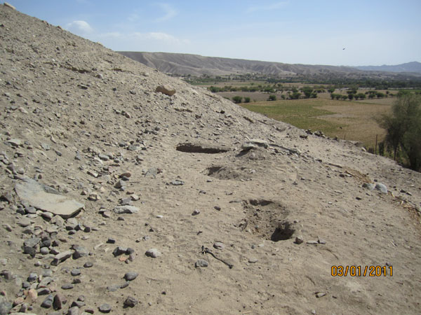
Figure 6. Steps on the slope.
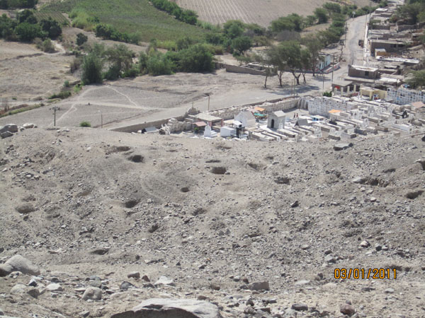
Figure 7. Character of the slopes.
In the background there is a modern cemetery of the town of Palpa. (NB: the holes in the foreground present ancient tombs unearthed by treasure hunters. They can be found practically at all levels of the mountain, from the top to the bottom. Confinement of the graves to the terraces indicates that they were made after the restructuring of the relief had taken place, therefore, they are younger.)
In this chapter, it is necessary to highlight the issue of water flowing from the tops of the elevations, because it is indirectly related to tectonics.
The fact is that in the process of the growth of hills, the masses composing them left the zone of lateral compression. First of all, this has to do with the tops. This led to the relief of tension in the part that had grown up and to the opening of cracks that had been tightly closed prior to that. It was along these cracks that water rose if its pressure was sufficient. The cracks opened the most at the top of the mountain, and they opened the least at its base.
Naturally, water used to trickle from everywhere, but if a hill was not very high, then water could partly reach the top. The pressure needed for the lifting of water was supplied by by the difference of heights between the areas of catchment and discharge. This could interest people in the case if the surface of the hill was covered with loose sediments and was horizontal enough, so that water would leave it too quickly. Then they could arrange an irrigated field. Of course, the growth of the mountains did not help that process. It was increasingly difficult for water to reach the tops, so the era of the mountains “shedding water” eventually ended.
Thus, several millennia later as a result of lateral compression coastal shallow waters and coastal plain turned into a desert plateau surrounded by mountains and half-dead rivers.
| << Previous | Contents | Next >> |


