

To display the site correctly, please, enable JavaScript.
Introduction
| Contents | Next >> |
Encouraged by the results of my research of the Maltese cart ruts and the megaliths of Carnac (France) I decided to turn to a more famous and mysterious phenomenon − geoglyphs of the Nazca Desert in Peru. As in two previous cases, I decided to go there and see everything with my own eyes, not really going deep into reading of everything written on the subject and leaving it for the future.
Things that I could not even dream of in 1974 after watching the film by Erich von Daniken"Memories of the
Future" now were about to come to life. However, there was little joy. Rather,there were more doubts that
we (my wife and myself) would be successful since we were going to travel in Peru on our own with our knowledge
of Spanish being at almost a zero level.
In addition to Nazca we planned to visit Cusco, Machu Picchu and if time allowed − Titicaca. Altogether
we expected to spend in Peru about a month.
In St. Petersburg, at two-month courses of Spanish, that I attended before the trip, I was lucky to meet Edgar
Pocheke – a Peruvian and a native speaker of the language who had been living in Russia for several years. He
helped us a lot in organizing the trip and hosted us in his large and comfortable home in Lima at the beginning
and at the end of our adventure. For this, my wife and I would like to express our gratitude to him and his
parents, under whose constant care we were there.
But our Peruvian acquaintances did not end with him. Our new friends eased our stay and work in this wonderful
but not yet a very prosperous country.
Edgar’s friend Jorghe Dirlavo personally purchased necessary topographical maps at the Institute of Geography
of Peru (IGN Peru) that I had not been able to purchase in Russia and sent them to us to Nazca.
Through the Internet I was able to get in touch with another Peruvian − Victoria Nikitsky, a womanwho was a former assistant and a friend of Maria Reiche, that very German woman, due to whose efforts the drawings of the Nazca Desert became known worldwide. Even now Victoria lives in Nazca and continues working singlehandedly in so-called "Center of the Study of Geoglyphs" organized by Maria Reiche, which now bears her name (Figure 6 at the end of this chapter). She tells visiting tourists about the history of the study of Nazca, introduces the existing hypotheses concerning the origin of the geoglyphs, shows pictures, and offers some literature on the subject. On occasion, she works as a guide helping small groups of researchers to organize their studies of the lines.
In the person of Victoria we found a cheerful companion, who, despite of her not so young age and hot weather,
accompanied us in every route. Her experienced eyes noted the marks of lines where we did not see anything
except a succession of sand hills wavering in the haze of very hot air. Depending on the situation, she worked
as a guide, a translator, andr the representative of our interests.
Due to a lucky hit and Victoria we met the director of the archaeological reserve of the Nazca Desert. He started with cold and official reproaches for breaking the rules of stay in the territory guarded by him. The reason was that on the second day of our walks we did not pay attention to a small sign with the words ZONA ARQUEOLÓGICA, when driving to our destination along a good dirt road, which was clearly used by anyone. Accepting our apologies and assurances that we did not damage the lines, did not do any digging and that we were not mere tourists but geologists from Russia interested in the ancient history of Peru, he became warmer and graciously answered our questions about the reserve. He also showed some areas on the map where walking was not prohibited, but where you could see many interesting things. Most importantly, he warned us not to enter the territory marked by the shields with the above mentioned inscription, not to touch the remains of ancient constructions and not to dig graves. The latter warning, as we could see later, was especially important.
Even walking along our small routes we saw dozens of graves dug out by "black archeologists" −
huaqueros, as they are called there. Around these places one can always find lots of human bones, fragments of
ancient pottery, pieces of fabric and the fragments of everyday objects, in short, everything that did not
interest the robbers. Funeral accessories extracted from those graves are a source of income for some of the
locals, who, as we could see subsequently, do not even hide their collections.
I started working on the problem of the boundaries of the reserve back in St. Petersburg. Preparing for the
trip I tried to find them online because even Erich von Daniken in one of his books about Nazca warned that
violators are punished by prison terms and unthinkable fines. But my search wasn’t successful. Now, having
become better acquainted with Peru, I think it is unlikely that such a map exists at all. Victoria did not help
me in this either. The only thing that I realized in the course of correspondence with her was that if someone
was going to study the Nazca lines as an official researcher then it was necessary to obtain a permission from
the Institute of the Culture of Peru (Instituto Nacional de Cultura (INC)). Clearly, this could not happen
either quickly or easily. However, I did not make a claim for such a status, as my experience told me that
getting answers to many "eternal" mysteries requires an attentive and dogma free view and a correct
«know how» in order to interpret the results rather than serious and costly research. Tips are there for all to
see, one must simply see them.
To those for whom Nazca is primarily the drawings of animals and birdsI am saying right away that I did not
have the goal to figure them out. An opportunity to understand the nature of geometric geoglyphs seemed much
more realistic. There were thousands of them while there were only dozens of drawings. Such an abundance of
objects distributed over a large area and found on different altitude levels and in various geomorphological
positions differing in shape, strike, scale, and color intensity would allow to identify some patterns in their
location. This, in turn, may lead to finding their purpose.
In the course of this work, I had very little hope that by some miraculous coincidence I would be more
fortunate than all the previous researchers of Nazca and find the answer which they could not find. I was very
modestly evaluating my knowledge of the life of the ancient people and therefore I did not believe in such
coincidences. I was solely counting on my geological «know how» − a new approach towards the relief
formation. I was going to apply the same approach that I used in Malta and in Brittany, which would allow to
imagine how the area looked in the past and see if the geoglyphs make any sense in that case. Of course, along
with this, it was necessary to consider how the transformation of the relief could affect the climate,
landscape, and the flow of certain natural processes. Was Nazca a desert as it is now? Was theret a forest,
water body, or something completely different? Was the seashore as far as it is now and what could be a former
regime of watering the territory?
This distinguished my approach from that of the previous researchers. They viewed the surface of the earth as a
solid foundation, which, when moving up or down, involves whole regions, but never an individual mountain, a
rocky ridge, a hill, a small ridge ,or a valley. Many of them even in their dreams could not accept the
possibility that the modern relief could be formed after the creation of lines. Thus they created the decades
of headache for other researchers, who did not understand how ancient people could have achieved such precision
of layout on rough terrain.
If you look at a compiled map of the geoglyphs of the north of Nazca (Fig. 1) the mystery of the lines and
drawings is only worsening. The objects are so numerous and they overlap so tightly that it seems impossible to
understand this phenomenon. One can see only chaos with a hint of order, which is manifested in the presence of
some dominant trends in the striking of lines and geometric figures, and in the presence of some centers from
which the lines diverge exactly radially. And then, anyone according to his/her preferences can interprete it
as the traces of aliens’ activity, a calendar, a connection with the heavenly bodies, or a coded message left
by more ancient and advanced civilizations for their descendants. (NB: to get an idea concerning the existing
versions of the origin of he Nazca geoglyphs I recommend to read a book by Alla Belokon "The Nazca Desert.
Traces of Alien Intelligence" (“Pustynya Naska. Sledy Inogo Razuma”) published by "Veche",Moscow,
2007. You won’t be bored).
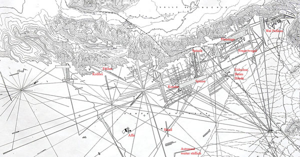
Figure 1. The plan of the geoglyphs of the north of Nazca (left bank of the Ingenio river) (from the site www.geschichteinchronologie.ch).
However, it was necessary to figure this phenomenon out, and I really wanted to see the geoglyphs closely, not from above as I used to see them while studying Nazca with the help of Google Earth site, without which this work would not be possible. I had to come down to earth in both literal and figurative senses, to walk in the desert and mountains hoping to see some useful details that might help to understand their nature. I wanted to understand whether there were differences between lines in the mountains and lines on the plains, lines among the stone and lines in the sands. Overall I wanted to touch everything that would allow at least on a subconscious level to feel the object of study, to become intimate with its logic. I even refused to fly over the desert because I did not want the spectacular view of geoglyphs from above prevent me from forming a balanced and less emotional perception of them from the land. This is where, in my opinion, Erich von Daniken got “caught”, because after perceiving the lines from the airplane as some ancient landing strips he could not move to a lower prosaic level of their perception.
Looking at aerial and satellite images of Nazca and Palpa provided by Google Maps as well as at plans and maps of geoglyphs I had a strong belief that we were dealing not with some higher and ethereal matter but with the prose of life, with something that people used to do constantly without caring what intricate compositions were being created as a result of their work. Looking at such sites as presented in Figure 2 I involuntarily thought of an analogy with a sheet of paper on which something had been drawn, then quickly and carelessly erased, then something else was draw, then it was repeated again and again, right on the top of everything else, as if the artist had no time. Seeing this sloppiness one can find neither any master plan nor any intention to create “a message for the eternity”. However, there is an impression that this was some kind of routine; that all of this was made, as well as the tracks of Malta, not for the purpose of some future demonstration.
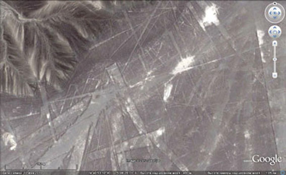
Figure 2. The overlap of lines in the northern corner of Nazca near the Ingenio valley. A photograph from Google Earth (GE). Here and below I always save the coordinates for the possibility of independent viewing.
A version that all of this was somehow connected with agriculture seemed to me the most appropriate under the given circumstances. Field systems with approacing roads and ditches were perhaps only analogy from the modern life that could be compared to the intricate network of geoglyphs in zise and in the diversity of their manifestations.
I've had the same sense of chaos and the lack of idea throughout the whole composition when looking at the map of Palpa geoglyphs created in 1998 by the Swiss-Liechtenstein Foundation for Archaeological Research Abroad together with the researchers from the Institute of Geodesy and Photogrammetry in Zurich.
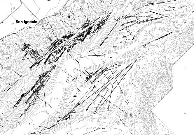
Figure 3. The fragment of the map of the geoglyphs of Palpa district. (once it could be found at this address www.geod.ethz.ch/p02/research/peru/Nasca/images/result3.jpg).
The chaotic jumble of lines in the places of their greatest concentration on the plateau was especially impressive (Figure 3).
But how all these lines could be associated with agriculture? This was the question. After all, the desert was near, and rivers, even if they were close, often located at a much lower level.
Yes, some of the lines, serpentine shaped, could very well serve as the elements of irrigation systems providing water to the area where they were located, while the others, straight as arrows, could under certain circumstances serve as channels of water. But what could have caused their overlapping, intersection, and divergence from some obscure centers? What was the purpose of the narrow wedge-shaped triangles and trapeziums which often appeared at the end of lines? Could they be fields as well? But why did they have such an unusual shape? And where was the soil? And, most importantly, where could water come from to supply the entire system. Did they pump the water from the bottom? We could not see any direct connection of the geoglyphs with existing channels of water from which they could have pumped it. On the contrary, the geoglyphs gravitated towards the hills and plateaus along the sides of valleys, as in Figure 3!
But even if the lines were located within the bottoms of valley, they always occupied local elevations. It seemed that, on the one hand, being located near the valleys they are gravitating towards water while, on the other hand, they tended to avoid it. Even taking into the accounta possible reorganization of the relief it was not clear what purpose the lines served: ensured the delivery of lacking water or drained the excess of water? There was no clarity, but I had a feeling that the current of my thought was correct.
It turned out I was puzzled by this question many years after Paul Kosok, an American historian who discovered the Nazca lines and launched their first serious study in 1939 as part of his work on irrigation systems of the ancient civilizations of Peru. It was he who invited Maria Reiche as his assistant in the studies of Nazca geoglyphs. She devoted all her life to these studies but could not solve them out.
Although Paul Kosok apparently quite quickly moved away from his original version towards searching the connection between the lines and astronomy the fact that the idea of the irrigation in the region attracted the attention of researchers encouraged me. So, we went to Peru with an idea that the geoglyphs were probably related to water and agriculture.
In conclusion of this section and for better orientation ofthe readers on the terrain I include the map of the
Rio Grande river basin (Figure 4). The Nazca and Palpa rivers are its tributaries. I also include a map of the
region giving a general idea of the relief (Fig. 5).
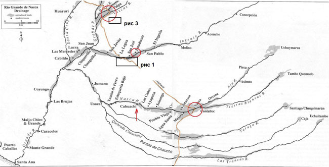
Figure 4. The sketch map of the Rio Grande basin is borrowed from the book by Helaine Silverman “Cahuachi in the Ancient Nasca World”. The mouth of the Rio Grande river is in the lower left corner. From top downward red circles mark the city of Palpa, village Estudiantes, and the city of Nazca. The arrow indicates a place called Cahuachi. A brown line marks Pan American Highway. A gray lane marks agricultural lands. Black rectangles indicate the approximate position of the sections shown in Fig.1 and 3.
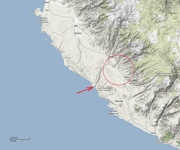
Figure 5. A regional map of the coast from Paracas and Ica in the north to the Atiquipa hills in the south (from Google map). The Nazca Desert is circled by a red line. The mouth of the Rio Grande river is indicated by a red arrow.
To reduce the amount of work and to make the perception of this paper easier I will do my best not to make my readers go a long way that I went myself in order to solve the mystery of the lines. There were too many dead ends and retreats. To explain how I got back to the right path would require extensive comments that would only confuse the matter. In some cases it reduces the strength of the argumentation, but in general, I think that presented material is convincing enough for all non-partisan readers.
A large number of photos attached by me to illustrate specific conclusions and assumptions are also supposed to show what ordinary geoglyphs look like. This, in itself, will help the readers to restore a calm and piety free attitude to this phenomenon that was often distorted in the works of the supporters of an alien interversin.
Below there is a photograph of so-called Maria Reiche Center. This is where Victoria Nikitsky lives and works as a director, a guide and a guard. A high wall topped with barbed wire and iron gates are, unfortunately, an indispensable attributes of many houses not only in the province of Peru, but even in Lima. This is a consequence of a very difficult economic situation in the country, resulting not only in crime, but in terrorism as well.
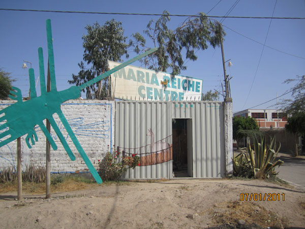
Figure 6. So-called "Maria Reiche Centre", where Victoria Nikitsky lives and hosts visitors.
| Table of contents | Next >> |
| Contents | Next >> |


