

To display the site correctly, please, enable JavaScript.
Application 1: Newgrange.
| << Previous | Table of contents |
When searching the Internet in order to find photos of tumuli protected at the bottom by a belt of big stones against washout I came across the site containing some information on Newgrange. It was also there that a book by Michael J. O’Kelly “Newgrange” was mentioned. It presents a condensed report about excavations that he was conducting since 1961 for twenty years. Having purchased the book I found there many interesting data in connection with my hypothesis. I could have dedicated a few chapters discussing the topic but I decided to limit myself listing the most outstanding facts some of which still do not have even a formal explanation.
The first and the most important thing was that Newgrange was surrounded by extensive talus practically along the whole perimeter. This cairn slip was composed of material similar to that which had been used for construction of cairn itself. The question of the origin of this cairn slip was one of the most important and it could be answered only in the course of excavations.
The very fact of the existence of this cairn slip is not surprising at all. It is quite natural that during a few thousand years the vertical wall surrounding the cairn was getting slowly destroyed. However there are some complicating circumstances. Firstly, the cairn slip of certain height is unusually wide and is located not at the foot of the cairn, which would have been natural in the case of normal deterioration, but strangely reached to the cairn’s top. So, it is unclear how could such evening of the surface of the slope take place and what was the source of the cairn slip then. It was so well blended with cairn itself that the first researches did not single it out but assumed that it was a part of the whole. Secondly, it had inner layering which made it resemble usual natural sedimentation mass. Thirdly, in its plane there were layers of turfaries. Fourthly, the bottom layer, which most of all reminds in its composition the material of inner backfilling of cairn, contained large amount of shells of ground snails and the remains of human vital activity of Beaker period (late Neolithic) while there were no traces of human activity of that period on the cairn itself. Thus, archaeologists made a conclusion that people used to live around the cairn but did not go over it. Fifthly, and that was quite strange, underneath the cairn itself there was a layer of ancient black turfary, but for some reason there was none of it outside including the area under the cairn slip. It was laid right on the underlying mineral deposits.
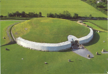
For a fuller picture I add here topographic materials on the cairn and cuts across its borders and cairn slip. In figures 5.11 and A1 one can see the remaining fragments of the cairn slip along its perimeter. The ditch dividing the slip from the cairn was dug during the excavations in the nineteenth and the twentieth centuries for extracting of the kerb stones.
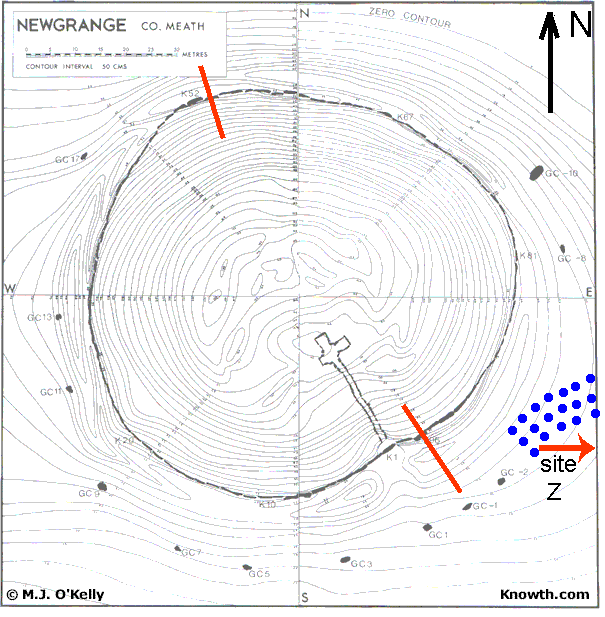
Figure A1 – Newgrange. Plan.
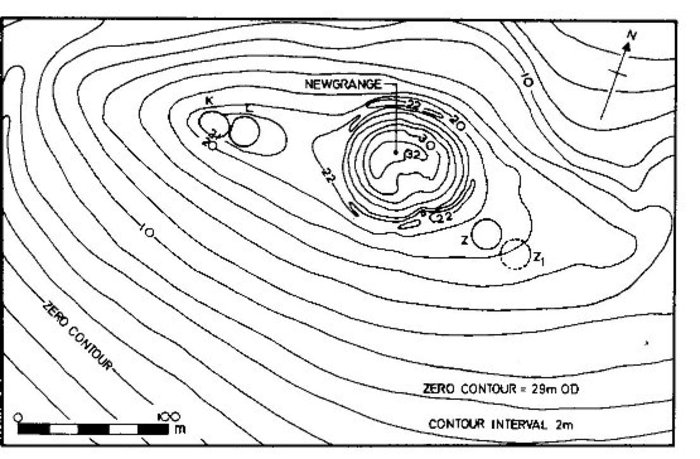
Figure A2 – Newgrange location in the modern relief.
Pictures from the book by Michael J. O’Kelly “Newgrange”.
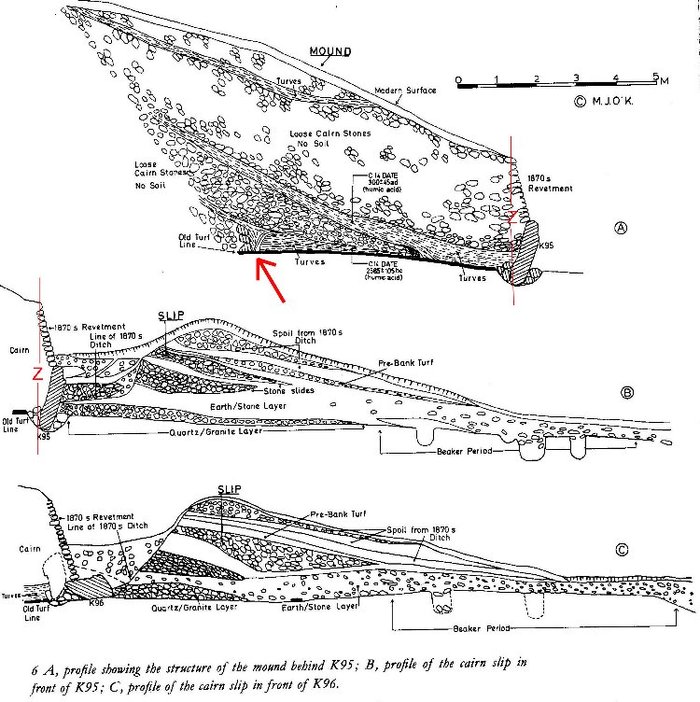
Figure A3 – the cut across the SE slope of the cairn and talus on the kerb stone (K96) located to the east from the entrance.
I think the readers have already guessed that I am trying to say that this cairn slip was not a result of natural destruction that can be seen near steep walls and cliffs, but has to do with wash away of the cairn during the flooding. Hence, the layering of the cairn slip and the peripheral parts of the cairn composed by the products of destruction of its top. Hence there is absence of any traces of human activity. Along with a superficial layer they were washed off and laid down at the footing of the cairn. It is shown in figures А3 and A4 as “EARTH/STONELAYER” thoroughly filled by shells of ground snails and artefacts of Beaker-period (Late Neolithic).
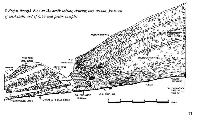
Figure A4 – The cut across the northern slope of the kerb stone (К53).
The assumption of flooding is supported by general character of deformations of the cairn found out at the excavation that greatly puzzled archaeologists. Stones К96 and К53 (fig A4 and А3) as well as all other kerb stones, upon which a low wall was established, are inclined outside while originally, as archaeologists established on the basis of the position of concavities, they had been inclined inside. It seems as if the cairn was pushed apart from within. As you see this could very well be the consequence of flooding. As a result its material settled and tending to come apart in different directions it pressed against limiting bottom stones.
You can make an experiment with a small hill of sand on a plate. Even in case of slow and accurate filling it with water the hill will settle and low down.
Similar changes took place in the corridor leading to the final chamber. Vertically established stones, which formed its walls, significantly bent towards each other. They also experienced lateral pressure.
Besides, the passage almost up to the ceiling was filled by stones and soil, the very material from which cairn had been made of. The heap was located strangely enough, its depth decreased to the middle of the corridor. The first 4-5 m one could move ahead only crawling, sometimes on one side, and only in the process of going deeper it was possible to kneel and then to walk. It has been described by one of Newgrange researchers (Pownall, T. 1773) who visited it after in 1699 at the extraction of stones from the slope of the hill for some economic needs this passage was found out and it became clear that a hill overgrown by forest was not simply another form of the relief.
In the area of the entrance a round form of cairn had already been broken. There was something similar to a mouth, which in a transformed form is repeated even now. However, the line of the kerb has not undergone any changes. Heavy stones opposite to the entrance remained, but the rests of the wall were not on them. Such position of the stones across the passage seemed strange and did not have any sense.
All of this very much resembled not a deliberate stone filling of the entrance by people as archaeologists assumed, and stuffing it by cairn material surrounding the entrance. The same way other cairn entrances were stuffed: the entrance of the Gavrinis cairn, the entrance into the cairn on the Carn island in Brittany, and the corridor in the eastern part of the hill Knowth, the neighbour of Newgrange.
There is another interesting observation that comes up here. For the first time the researchers in their notes mentioned finding the remains of two people lying right on the floor. One cannot tell for sure if it was so, but during the modern excavations of the chamber’s floor there were found unburned scattered remain of at least two humans: teeth, bones, etc. One can naturally say that this is another evidence that Newgrange and similar monuments are burial places, but there can be another version. It could be that those people perished in this chamber during the flooding. It was not easy to get out of such cave even if water did not get up to the ceiling. They would have to dive and swim under the water – the entrance was 2 m lower than the floor of the chamber where the people were supposedly waiting for the end of this natural disaster.
This way one can explain some mysterious situations, which archaeologists encountered when excavating megaliths. Among others it is filled entrance into the Gavrinis tumulus (Bretagne, France) with no traces of burial. It is the disorder, which is often found at opening of such “chamber tombs” as it was in ManeRutual (Lokmariacer, Bretagne). Sometimes it is the arrangement of objects, but some other times – with arrangement of human remains. The best example of the latter phenomenon is a well-know barrow in WestKennet in Wiltshire (England) where inside of a similar corridor structure, among disorderly stone heaps there were found remains of about 50 people – old men, children, adults. There too the corridor was stuffed by the barrow material up to the ceiling, and the entrance was blocked by big stones that were located outside, seemingly for protection against the waves during occasional flooding. One cannot explain it by later human interventions because there were no traces of human intervention.
Nowadays West Kennet is considered a group burial place.
If our assumption that "corridors" are not tombs, but places where people perished is true, that would mean that water rose so quickly and suddenly, that people had not time to be rescued. However, the speed of flooding could differ depending on a local relief.
There is some indirect evidence that testifies about periodic rising of water that had taken place around Newgrange prior to the supposed catastrophe. There is a powerful kerb made of blocks protecting cairn against wash away. Then, this extensive cairn slip did not lay on a layer of black ancient turf, which is now preserved only under the cairn itself, but on the underlying deposits. This easily destroyed layer could be washed away long before the big flooding from unprotected surface of the hill by regular flooding. Consequently the wall material together with internal backfilling and some kerb stones fell onto already smoothed surface. O’Kelly explained it the way he could under the circumstances: supposedly surrounding layer of turf, like grass, had been cut off by people for some reason.
One more acknowledgement of periodic flooding of the place where the cairn was located, was finding in the northern incision in the foundation of the barrow a rather thick layer of young turfs (fig. А4). The vegetative debris composing it, as O’Kelly informs, were so well preserved, that at the opening even had green colour, which quickly changed into brown at contact with air. Buttercups, Blinks, Chickweed, Knotgrass, Common Dandelion, Stringingnettle, Blackberry, Crabapple, etc. were found out in this layer at macroscopic studying. In the majority these herbages grow in low marshy meadows. In my opinion, it is that vegetative waist, which we mentioned in the section dedicated to alignments in the vicinities of small town Carnac. Quite probably, ancient people collected it here as well. The layer with such high degree of preservation of vegetative material could have only the water origin. In the air the vegetation would simply decay. But at the same time it not a swamp deposit «insity» which could have existed in this place. The rests of an apple-tree, blackberries, a dandelion, etc. testify of that. Most likely, interbeds of turf and loams were laid over and over again at rising of water, in the form of inwash to the north, behind a small barrow from which the construction of the cairn had apparently begun. Its rests, -- low rubby wall three stones high, -- was found in the central part of the cairn during the excavation (fig. А3, marked by an arrow). At the subsequent expansion of the construction this mass of turf happened to be partially buried under it.
Accumulation of such light deposits occurred for the same reasons that had been put in the basis of functioning of barrows and alignments of Brittany. They accumulated in the "shadow", stagnant zones behind obstacles.
It is very likely that there were alignments here as well. On the eastern side of the entrance into Newgrange at the removal of a superficial layer of the soil many concavities were opened. They were organized in the form of arching strip less then 10 m wide and about 50 m long (they are symbolically shown by blue points on the plan in figure А1). The stones which had been set in them could be used for construction of the big cairn. Many of those stones bore traces of a double sided engraving testifying about an easy access to both sides at certain time. The purpose of alignments could be the same as in Bretagne – gathering of vegetative waist for making habitable in winter or for covering of dolmens.
It is hardly necessary to hold archaeologists who observed all these facts responsible for not assuming the flooding of cairn. Coming from accepted geological views including evolution of the sea level in a postglacial age, this could be only dreamt of, in fact, Newgrange is now at the height of 50 m!!!
Thus, well-known Newgrange and accompanying constructions lose their image of a prehistoric temple complex and simply turn into places of temporary stay of people during periodic flooding, which slowly, one time after another filled more and more extensive territories. They were precisely the same artificial islands as Barnenez and Gavrinis as well as many other barrows and tumuli. Besides, quite often they were also constructed in different stages, each time increasing in width and height. This had to do with the process of changing of the level of flooding or increase of the number of people who were rescued there.
A well-known phenomenon of a ray of light, which on the 21st of December at the sunrise reaches the depth of its chamber through an opening in the roof, had become one of the main reasons why the whole construction received the status of the Prehistoric Temple and such popularity in the world. Most likely it is an accident. Tens if not hundreds of corridor "tombs" constructed precisely according the same principle both in England, in Ireland, and in France, including the neighbouring "tomb" located in 40 m to the east of the entrance into Newgrange (so-called siteZ), cannot boast of such distinctive feature. In fact it would not be much work to allow for it during the construction if it was really needed. So, probably, there was no such thing as the solar cult? Furthermore, the inclination of the axis of the earth in relation to ecliptic then, before the reorganization of the relief most likely was not 23º but a little less, consequently the climate on the earth was more equal and soft with minimized summers and winters And the sun on this critical day simply did not ascend where it ascends now. In this case all modern «solar adjustment» of Newgrange gets off.
The mentioned change of the inclination of axis could also be caused not by cosmic but by internal reasons – by planetary reorganization of the relief. As a result the eccentric weight of earth mass increased, and consequently the amplitude of precession increased as well.
And one more circumstance: it is hard to believe that ancient people planning a corridor for solving such "astronomical" problem would not try to make it more even. Its present bends cannot be written off on the subsequent deformation of the cairn. So originally in concavities wall stones were established. And if the corridor and the chamber were used for the household purposes, straightforwardness was unimportant. People could hide in such shelters, for example, during cold weather. Now the temperature inside Newgrange even in the winter does not fall below +10 degrees of Celsius.
There is another strange thing, not very appropriate for burial purposes of the construction. It appears that the plates of the corridor roof and the arch of the chamber had numerous hollowed channels on the top, which were to draw aside the water leaking through an overlying soil – in fact ancient people did not have special waterproofing layers. By such labour-consuming and not very reliable way people, as it seems, wished to provide dryness in the underground vault. May everyone decide for himself/herself whether it was necessary to do this for the dead.
When studying O’Kelly’s book I came across some interesting information to which the author had dedicated one or two paragraphs in the eleventh chapter where he had explained a realized by him (and existing until now) version of reconstruction of Newgrange, where it has acquired its super-extravagant appearance. It appears that a similar cairn slip was at the cairn Barnenez in Brittany, but during the excavations there were found the instruments of not "stone", but “iron" age underneath. This removes the time of flooding from the time of the Flood and makes it essentially closer to the time of the invasion in the Mediterranean of so-called sea people during 1300-1200 BC (NB: however «the Bible chronology» is not that simply explained and having understood the reasons of the events that had taken place on the earth we will have to deal with that chronology too).
Thus, here again, though in some distance from Brittany, the results of the research carried by absolutely unbiased authors show the signs of two important points. Firstly, that cairn was located in the zone of periodic flooding. Secondly, at a certain time the cairn has undergone full flooding, therefore it has been seriously destroyed (as many other cairns) and after that it was not used any more. The report of O’Kelly enables to assume that this occurred during so-called Beaker-period after which, probably, "new" time and "new" life that is going on until now began. Besides, having understood that the whole cairn was flooded (the occupation layer was missing even on the flat top), we can conclude that the level of the rising of water exceeded its height, e.g. was more than 10 m high. Even now such floods are usually accompanied by great number of victims.
In the conclusion of this chapter I would like to note how important it is to be absolutely sure of the understanding of the purpose of such in many respects unclear objects before starting their reconstruction. One should not simply with some degree of probability assume things and write off on cults and rituals all that is not clear, but find answers to all riddles and paradoxes. To coordinate them in a uniform logic system, not squeezing them into Procrustes’ bed of our assumptions. And only with full confidence of the correctness of our answers we can start any reconstructive operations. Only then it would be possible to solve what is more important for us now, an “original” appearance of this “island of salvation” or its looks after the flood – reminding about that terrible event, which cardinally changed the life of all mankind.
| << Previous | Table of contents |


