To display the site correctly, please, enable JavaScript.
Chapter 3: Conclusion
In the central part of the southern coast of Malta, near Dingli cliffs, there is a site of the temples Mnajdra and Hagar Qim. Coordinates “Google Earth” – N35° 49′ 39,75″, E14° 26′ 31,63″.
Now these structures are located on one coastal slope, but on different levels. The difference between them is about 40 m. However before the catastrophe the surfaces on which they were constructed were almost on one level. Besides, Hagar Qim was built on the coast of the main land of paleo-Malta, while Mnajdra was built on a small island, separated on the north by a strip of coastal swamps.
If you look at a fine quality space photo published by Google Earth you will see that the terrestrial surface has different coloring. The areas that used to be covered by lake-marsh deposits now have a characteristic light grey background. It is caused by the color of limestone surface that became exposed on them which is seen in numerous photos of the ruts. It is the color of dense thin crust 1-2 mm thick. The formation of this crust is also connected to the process drying deposits. Now it protects limestone from destruction. It is the presence and perseverance of this crust that allows me to think that the surface of limestone and the tracks did not become subjects to erosion, which means that they were formed quite recently.
The places of the former land in the photo are characterized by darker brown color covered now by clay soils and ferruginizated deposits of lagoons.
So, looking at the intensity and character of coloring in aero- and space photos one can easily tell the places on Malta and Gozo that used to be covered with lakes and bogs in those ancient times and thus partly restore its paleography. I said “partly” because some territories are inaccessible for such analysis. Some of them are covered by water while others are changed by people to such extent that they have not kept any traces of what they used to look like before.
A cart-rut going down the height from Misqua tank crosses a foot path between two temples. This points out to the presence of people’s dwellings which were settled somewhere on the ancient coast even farther to the north of the above mentioned reservoir. Apparently people did not leave those familiar places at once, because after the catastrophe they still had time to dig in the rock some holes for water. Their circumstances were not as critical as they were for others. The raising of the land removed them a little father from the sea, but has not cut off from the water. The shore here was smooth enough. Thus the rut here might not be due to evacuation of the whole dwelling. It could be left after moving the cart closer to the shore to a lower place.
What was the reason for constructing temples? Was it only the closeness to the stiffened crusts or something else that determined a choice of the place of temples’ construction? Now it is not clear. May be they were simply houses which were built on places of former settlements. May be the builders used them to mark some significant points for themselves. Or, may be, these constructions were to remind of perished people inhabiting these parts of land before they plunged under water.
In one of the most mysterious places of Malta – an underground temple Hypogeum, Hal Saflieni − parts of skeletons of about 7000 people were found out in the beginning of 20-th century. It was not the remains of the bodies but bones brought here from somewhere else. Who knows, may be they were the remains of the bodies of the people who had inhabited the land which had gone under water, who had sunk in the sea and later had been thrown out onto the coast of Malta. Much later when the islanders recovered after the catastrophe, they probably collected all that remained from the coast and buried them in a special place created for this purpose.
It looks that this underground temple was also being created in raw, not yet hardened rock. An evidence that speaks in the favor of this assumption is that each subsequent room of the temple starting from the entrance was built one level lower. It seems that its founders were going deeper and deeper moving away from the border of hardening rocks above.
Site San-Pawl tat-Tagra, Naxxar. (Coordinates of the centre GPS N35° 55,513′ E014° 26,128′)
The site is located on the western slope of the hill on the top of which the village Naxxar is located. Photo 37 is a view from above. The main feature of the site is that a track is lowing from top of the hill as a serpentine. The relief is poorly seen on the aero photo, therefore the cliffs and a general angle of the slope are shown Here one can see that the slope going down from right to left is complicated with small scarps of meridian extending. The height of the scarps decreases from the north to the south. They have the greatest height in the top part of the picture near the turn of a road.
Right here from under the embankment on which there is a small building, one of the cart-ruts appears crossing a small scarp 2-3 m high (see a photo 38).

Photo 37 - Aerial photo of the site San-Pawl tat-Tagra, Naxxar . (photo by Daniel Cilia from “Malta prehistory and temples” by David H. Trump)
A plan of scarps’ location Red color stands for cliffs
Blue color stands for the direction of the sledges’ movement
In the upper part of aero photo the place is shown photo 38
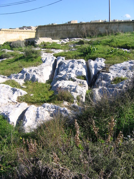
Photo 38 - Descent of the cart-ruts from a scarp.
Look, how deeply the cart-ruts are cut in the slope. Sledges were literally sinking in silt which must have been very soft on this site. Such places clearly show that the direction of movement was downhill, not uphill. It would hardly occur to anybody to climb this scarp in its most steep place if 100 meters to the south where the scarp disappears it was possible to climb up much easier.
If one follows in this direction farther to the west, in about 50 m there is one more scarp, much steeper and higher. People did not risk climbing down there, though it would significantly shorten the distance. They turned their transport to the south and dragged it along this big scarp until it looked safe for them to go down. Then they easily crossed it and continued their descent downwards.
Another group of people whose sledge traces also begin at the small house did not dare to cross scarps at all. They continued their movement in the southern direction, apparently having preferred slow descent along the slope.
Here we can also see splitting traces, which testifies to the movement of a few carts along the same way and leaving this way when necessary.
Judging by the arrangement of the ruts and their amount the settlement from which those people were coming was somewhere in the north-east part of the top of the hill. And though the sea was located to the north of this supposed place of their settlement, the movement straight to it was complicated by the presence of steep cliffs on the north. It was easier to go round moving to the south.
I shall use a chance to note that the above mentioned scarps are the very manifestation of the tectonic activity that had formed the relief of the island. Before the catastrophe this site represented the lowered swampy strip dividing hardly elevated spots of land located on the west and the east. Its borders can be perfectly restored with the help of space photos.
Another outstanding feature of the given site is the age of limestone attributed to it by geologists. The geologists consider them the most ancient among all Maltese rocks - 25-35 million years. Taking into account that there are still many traces of people on this site (see Photos 27 and 28) the information about it can be used in the section called “The earliest traces of people’s activity” in the Guinness book.
This is a joke, of course. In reality I do not have any reasons to doubt the age of the highlighted in numerous cliffs of Oligocene and Miocene coralline limestone. I doubt only the age of those limestone which are spread on the surface across Malta and Gozo at the places with cart-ruts as well as similar limestone at the places without cart-ruts.
Sites Dwejra, cape San Lawrenz, and Ta Cenc on Gozo. (Photo 1 & 2) Coordinates is coordinates table at the end of chapter 3
These sites are especially interesting because the cart-ruts here got printed not only on so-called swampy limestone but also on the real marine globigerina limestone. The latter are characterized by smoother surface, absence of holes inside, and the presence of large and well kept sea shells of Pecten and armor echinoids right on the ruts on the surface of limestone.
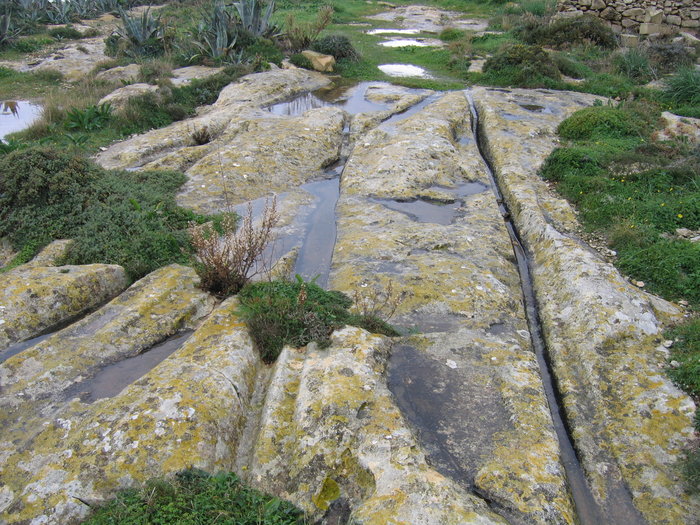
Photo 39 - Site Ta Cenc (Gozo) Tracks going along the cliff
The prints of cart-ruts in this limestone are characterized by smaller width of a separate rut (while the distance between the ruts is the same) as well as smaller depth of the print. This is because the layer of organic silt cover was thinner here. The runners cut it easily and consequently the prints are closer to their real sizes. The second reason is that the deposits on which these cart-ruts were printed had greater density and did not let sledges go in deeper. The difference in density is perfectly seen on the site Dwejra (photo 1). Right at the end of the rut, before it disappears, it crosses small outlets of typical marsh porous limestone. Consequently the depth of the track drastically grows from 10-15 sm to 40-50 sm. Sledges went into silt having left on it deep drag grooves 10 m long. The photo of them is frequently used as a visit-card of Cart-Ruts.
Such difference in deposits’ density may be explained, first of all, by the difference in the age of deposits. According to accepted among geologists view globigerina limestone were formed 15 – 25 million years ago, which means that there was enough time for them to get condensed. The covers of mash limestone were formed on them much later when land appeared on the surface of the sea. It immediately began to be washed away and consequently did not have time to get hard.
The tracks on these sites are especially important for us also because they testify that the sea globigerina silts remained plastic up to the moment of drainage. That is for the same 15-25 million of years from the moment of their formation, if geologists were not mistaken with age, the deposits did not harden and did not turn into limestone, but only got a little condensed. And only after drying they really hardened. Such difference between time of the formation of deposits and the time of its lithofication, i.e. transformation into the rock, which we see now, should not be overlooked. Even according to geological measures, the top limit of their age is 15 million years, which is a very long time. There is a question then what should we count as the age of formation of rock: the time when the deposit formed or the time when it turned into limestone?
Depending on the problems being solved it is possible to choose one or the other variant of the answer. However, the main thing as it seems to me is that within the framework of an explanation offered in this article the problem of the difference of the time of formation of the ruts and the age of deposits containing them can be solved. This way the second important obstacle that did not allow even to assume a possibility of the occurrence of prints made by ancient transport on the deposits formed millions years ago is eliminated.
Despite of the opened opportunity to reconcile the age of ruts to practically any age of limestone in which they were made I should express doubts concerning so-called the lower and the upper coralline limestone, more precisely, only those kinds which are distinguished by the Maltese geologists, particularly on the sites with cart-ruts.
As I have mentioned earlier, the age of different kinds of limestone is now considered to be 35-25 and 7-5 million years. According to a number of rather specific features it is very likely that they are the same formations of the same age and origin generated not very long time ago and not in the sea, as it should follow from the name “coralline”, but in the shallow lagoons with fresher water due to the washout of the more ancient underlying deposits. This strange similarity of the rocks divided by twenty millions of years was noted by scientists before, but only the cart-ruts helped to understand that their similarity is not accidental. The fact that these deposits were re-deposited has played a fatal role in determination of their age. Ancient fauna of mother sea deposits remained in them, but new fauna did not appear since washout occurred in the most unfavorable conditions for the life of organisms capable to turn into minerals, that is, in the conditions of fresh-water pools. Attributing certain age to the deposits formed in such condition is always a serious problem in geology.
Site Dweira is also interesting to us because here we can observe tectonic activity in forming modern forms of relief. Going up along the cart-ruts along the isthmus separating Inland Sea from the sea we cross a few small (from a few centimeters up to half a meter) tectonic steps on which the growth of the isthmus and the height itself (photo 40) was taking place. This “staircase” is finished by a 3 meter scarp at the very top of the hill. Its photo was submitted above for an illustration of the tectonic character of such formations very widely spread on Gozo and Malta.
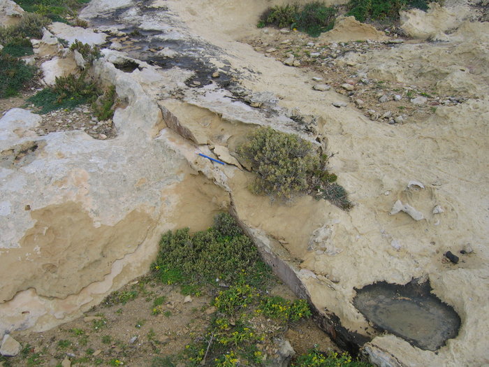
Photo 40 - Tectonic steps
Here one can perfectly see light grey reserving cust (Photo 41) covering, in my opinion, the deposits drained during the catastrophe which we mentioned earlier. Here one can also see how intensively limestone eroded in the places where the cover had been destroyed. The limestone became friable and loose. Its particles losing the connection with each other begin to form claylike masses, which become viscous in humid conditions. Limestone in the walls of Maltese houses is getting destroyed in a similar way. All of this confirms that a usual micro relief of the surface of limestone, shown in numerous photos, is not a result of erosion, but has an original nature.
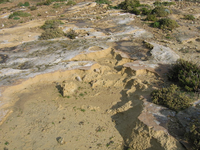
Photo 41 - Armour crust and erosion of limestone
It is necessary to add that on site Dwejra, judging by an arrangement of the cart-ruts, the ancient settlement was near the top of the nearest hill, possibly at the place of a modern quarry.
On the second site called Ta Cenc, except for the ruts one more interesting trace of the activity of ancient people was found. It is notches on the surface of limestone that look like strips (see photo 42). Fragments of them can be found almost on all sites with the ruts which I mentioned in this article. Sometimes it seems that they are leading to caves, as on the site Clapham Junction and Naxxar Tat-tagra. Other times their direction is not clear.
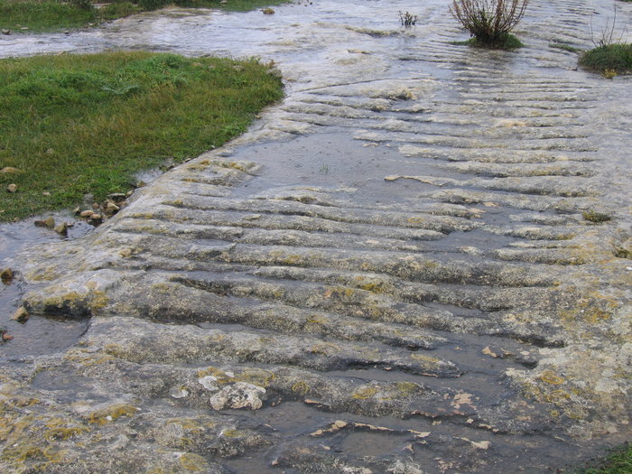
Photo 42 - A strip with notches
The last site which we shall consider is the same one which we began with solving the mystery of cart-ruts. The coordinates are presented in the special coordinate register at the end of the chapter
The site is located within a small town called San-Guan, at the top of a low hill and is surrounded by a mesh fence. The site is characterized by a rather high quality of prints. It contains a place where some pairs of cart-ruts (see photos 11 and 12) are very visibly and clearly crossed, although when looking from above it becomes clear that there were only two tracks (photo 43).
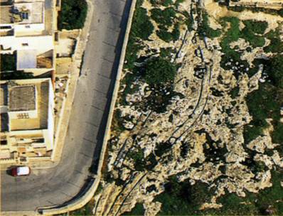
Photo 43 - The top view of the site in San Gwann. (From “Malta: prehistory and temples” by David H. Trump)
Now let us try to understand the reasons that determined the arrangement of the cart-ruts on this territory. We shall begin with a place where the cart-ruts cross or go apart. It is on the very border of the site (the bottom part of the picture). The cart-ruts coming here (if there were any) are now covered by the modern road and town buildings. If one takes a close look at photos 11 and 12, then what at the first sight looks like a chaos can be actually distinguished as three pairs of the ruts. The first pair left by a sledge with wide runners (the distance between the centers of which is about 145 sm) had gone to the left. The second and the third ones with narrower runners and the base between them of 135 sm had gone to the right. The depth of the ruts in this place shows that the sledges went deep in clay. The depth of ruts reaches 60 sm. This place is also marked by small lowing of the relief.
Apparently, in those days there was a hole here covered by organic silt. The fact that three pairs of sledges got into it tells us that they were dragged here not at he same time. Otherwise two other pairs of sledges would have gone around this hole after the first sledge had gone into it. But why did they proceed in different directions after passing the hole? The thing is that ahead (and it can be seen even now) there was another lowing. People might have thought that crossing it would be even more difficult than getting out of the first hole. And consequently they went around it. A bigger and heavier sledge proceeded to the left, and two lighter pairs with a track of 1.35 m went to the right. Tracks connected again in about 50-60 m when the road became smooth once again.
On this site for the first time it was possible to find something which we had assumed: more or less distinct footprints of ancient people (photos 25 and 26). These oblong prints are far from being perfect, but we already mentioned the conditions in which they were made. And, in general, there are a lot of such roughnesses which may have been footprints on other sites.
The direction of the movement of sledges was from the south to the north towards the seacoast. This follows from general logic. The “crossroad” from which our description began testifies to it as well. Now it would be hardly possible to determine where those people were coming from, where their former settlement was, and where the path was leading to, the “notch” fragment of which is here.
In the conclusion of the description of this site, once again I would like to draw attention of the readers to the form of the cart-ruts. Have another look at the photo of a “crossroad”. It is hard to believe that people looking at it could assume that the tracks were hollowed or worn out in the hard rock. There is the only one answer: incorrectly restored history of the geological development of the islands and inability of geologists to explain how at such heights there might be plastic deposits, and why they hardened later. So erroneous presuppositions interfered with imagination of scientists and did not allow them to move in the right direction.
Conclusion
It was certainly very interesting being in Saint Petersburg far from Malta and having only memoirs in my head and photos in my camera step by step to untangle during these two years the tangle of riddles surrounding the cart-ruts and temples and as a result to understand how the events were developing in those ancient times. And though an assumption that ruts were prints was born almost at the first look at them, a deeper understanding of the conditions anticipating their occurrences and all subsequent collisions and metamorphosis having taken place there did not come at once.
But the main thing for me although it might seem strange was not solving this archeological mystery. The main thing was that this example has illustrated inconsistency of modern geological views on the origin and evolution of the relief, and the role of erosion and tectonics in this process. This inconsistency resulted in stagnation of the search of real answers concerning the nature the cart-ruts. The remarkedness of the given case is that the relief of Malta and Gozo is not unique, it is the most usual relief, and it is seen in the pictures. However, anyone would take it for an erosive relief without much thinking. Consequently, I think, that there are more than enough similar geological mistakes worldwide the importance of the consequences of which many geologists cannot even estimate. Uniqueness of the situation on Malta is that here only due to the presence of the cart-ruts it was possible to establish tectonic and catastrophic character of relief reorganization. Without the cart-ruts it might not have become clear for a very long time.
Please, leave your opinion about this article.
Coordinates
| Name | GPS | Google Earth | ||
| N | E | N | E | |
| Dwejra point (Gozo) | ||||
| Cart-ruts (Photo 1) | 36° 03,260′ | 14° 11,385′ | 36° 03′ 15,10″ | 14° 11′ 22,83″ |
| Scarp of the top (Photo 19) | 36° 03,360′ | 14° 11,542′ | 36° 03′ 18,87″ | 14° 11′ 31,52″ |
| Ta Cenc (Gozo) | ||||
| Cart-ruts (Photo 2) | 36° 01,127′ | 14° 15,117′ | 36° 01′ 05,39″ | 14° 15′ 06,86″ |
| Dingli cliff (Malta) | ||||
| Cart-ruts near Madelena Chappel (Photo 5) | 35° 51,094′ | 14° 23,217′ | 35° 51′ 06,80″ | 14° 23′ 14,34″ |
| Clapham Junction (Malta) | 35° 51,080′ | 14° 23,748′ | 35° 51′ 06,07″ | 14° 23′ 45,20″ |
| Cave Dvellings (Photo 29) | 35° 51,162′ | 14° 23,823′ | 35° 51′ 09,51″ | 14° 23′ 48,78″ |
| San Gwann (Malta) | ||||
| Cart-ruts (Photo 11, 12 ) | 35° 54,725′ | 14° 28,728′ | 35° 54′ 40,40″ | 14° 28′ 41,00″ |
| San Pawl tat-Tagra, Naxxar (Malta) | 35° 55,530′ | 14° 26,223′ | 35° 55′ 34,60″ | 14° 26′ 19,74″ |


