To display the site correctly, please, enable JavaScript.
Chapter 2: How it all was
Many thousands or may be millions years ago, at the place where today one can see the rocky coast of Malta and Gozo, groups of low islands surrounded with shallows started to occur above the surface of the sea. Their contours did not remind the modern ones at all. They were not piled of rocks. They consisted of carbonaceous silts soft as clay, like those that nowadays lay at the bottom of the sea around Malta. In due course, during the raising process, the islands began to increase in size and joined together. The straits between them began to disappear gradually turning into gulfs and lagoons. Later, some of them completely separated from the sea and in the conditions of a more humid climate first turned into fresh-water lakes and later into swamps.
The fact that the climate in this area used to be more humid does not cause any doubts. A few thousand years ago the Sahara desert located nearby was a savanna with lakes and rivers filled with fish, crocodiles and hippopotamuses. Hunting scenes for these animals are found in the centre of the desert on Tassili n’Ajjer plateau.
On the other side, on the territory of modern Egypt along the Red Sea, where the ground is a completely burnt by the sun one can see traces of numerous rivers. The dried up valleys – “vadi” − are still perfectly visible from the air. Back then in the ancient times many of these valleys were filled with water and were used by ancient people as means of communication. The evidence of this is some drawings representing people sailing in boats that are found on rocks in the desert tens of kilometers away from the sea.
Farther to the east in the interfluves of the Tigris and the Euphrates during the 3rd and the 4th millennium BC the surface of the ground was so watery and boggy that the ancient Schumer began to create a network of melioration channels for its drainage. In general there was no lack of fresh water in those days. There was plenty of fresh water on Malta as well.
In those days the islands were covered with vegetation. In lower places there were lakes and swamps. The southwest of Malta was especially low. However nowadays we have the most mountainous relief here. The same is true about the northeast end of Gozo. Today we can see here the systems of flat-topped hills. This is also true about the southern part of the island, near the valleys of the rivers Xlendi and Hanzira.
The location of lowlands here, as well as everywhere else on the Earth, is not accidental. They designate the places of troughs. Consequently even in the area of a greater relief elevation the reservoirs of water existed a little longer than in other surrounding territories.
In this period paleo-Malta was full of life. Giant swans, dormice, hedgehogs, turtles and dwarfed pygmy elephants used to live in woods. Herds of dwarfed pygmy hippopotamus were grazing in the swamps. Till now the bone remains of all these animals are periodically found in caves, clefts and old stream beds. But most of them were found in a karstic cave Ghar Dalam in the southeast of Malta. The remains of hippopotamuses deserve special attention. Teeth of these animals in great amount have formed a layer half a meter thick at the bottom of the cave, testifying that during thousands of years many generations of hippopotamuses lived and died here standing knee-deep in water. All this data tells us that in recent times the conditions of life on Malta were very favorable for them. Hence, the first questions rises. When looking at the modern rocky Malta it is difficult to imagine where the herds of these animals might have found food. Where were the lakes and swamps in which they lapped? And the most important question is where their deposits are?
As all listed above animals are not great swimmers and they could only migrate to these places overland it is obvious that Malta and Gozo were not islands then. They were connected to the continent. This idea is supported by the fact that a number of remains of similar dwarfed elephants and hippopotamuses were found on the Sicily nearby. There was a connecting bridge which is now seen as a flat, submarine bar-like elevation at the bottom of the sea. It could be used by both animals and men.
Naturally people were settling on the coasts of water reservoirs, near the places of hunting and fishing, which were close to fresh water. As coasts of these flat shallow lakes, most likely, were marshy, ancient Maltese as well as their European contemporaries could be called “swamp inhabitants”. It could be that they constructed there homes on piles.
Their economy was typical for the Stone Age. They lived by hunting, fishing and collecting. They built neither roads nor stone dwellings. Those things were not necessity. Besides there simply were no stones around! Under a layer of soil there were clay-like carbonate deposits, that had not hardened yet. Thousand or millions of years ago they used to be the sea silts. Only along the shallow sea coast low cliffs begin to occur here and there (photo 13). Waves slowly washed out superficial niches in them.
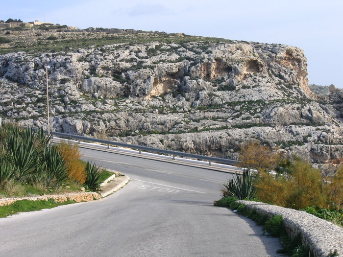
Photo 13 - Malta. A belt of caves in the rocks near Blue Grotto.
They are still there. One can see them at the upper levels of the modern coastal cliffs. These areas became the first rocky formations of the appearing land.
And now let's think what kind of transport used by ancient people who lived in those conditions could leave traces in a form of ruts?
On one hand, those people lived by water, went hunting and fishing and obviously needed some sailing equipments. What could they create in those ancient times? Wooden boats? However, even simple stones, let alone flint or diabase, needed for making chisels and scrapers, were a deficiency. How could one construct even a simple boat without these tools?
I can think of two most possible options. The first one is that they could use reed boats similar to Egyptian ones. Reeds could very well grow in such marshlands. However reed boats when dragged from one place to another would leave no traces on the ground. The second option is that they used something similar to rafts.
However rafts are not easy to handle. Under a sail they can move only downwind. Besides they get wet and heavy when kept in water for a long time. Consequently they constantly require to be pulled out onto the coast for drying, and it is hard work.
I may be mistaken, but it appears to me, that some of the above mentioned problems would have lessened, if ancient people had come up with an idea to equip their rafts by small keels on each side made of thin logs, that would have turned rafts into something similar to catamarans. When in water they would have additional floatability. Besides, this invention would have reduced lateral drift. Then when dragging a raft onto an oozy coast the keels would work as sledge runners. Such rafts when being drawn might have left traces similar to the ruts.
There are two reasons why this assumption does not appeal to me. First of all, although sailing by such catamarans has a few advantages, there are also some important disadvantages. Their rather deep seating in water essentially complicates approaching the coast and navigation on shoaliness. This could be important in the assumed conditions of a flat island relief. Second, when looking at the tracks one would understand that whatever left them had carried significant loads during such travels. Hence, most likely, that kind of transport was created for the purpose of transporting loads in the first place. In that case it was not keels which did not require such firm connection to the frame but rather runners. So it seems to me that it must have been sledges.
Low and flat relief of the islands with big swampy areas also predetermined the usage of sledge-like transport. Sledges could be even used as rafts when crossing small water reservoirs. They could also be used for delivery of killed hippopotamuses or elephants to people’s dwellings.
I want to point out that in the north of Russia, in tundra, big iron or timber sledge connected to a tractor or a cross-country vehicle are frequently used till these days for the purpose of moving small houses of geologists or drilling equipment from one place to another. Although Europeans view it as barbarity because such trips leave two deep drag grooves that never heal on the surface of tundra, there is no cheaper and more convenient way for transportation of heavy loads. Ancient Maltese could operate in exactly the same way with the only difference that instead of tractors they dragged these sledges themselves.
The experience of northern peoples testifies that a sledge is the best transport even in the summer time for moving loads across boggy tundra covered with moss. Its runners slide on moss and grass just as well as on snow in the winter time.
The difference in sledge sizes of the Northerners and ancient Maltese could be caused by the purpose they were used for. The former are focused on high-speed transportation of people on boundless open spaces of the north. Therefore the sledges are narrow and long. The latter were focused on transportation of great weights across swamps. Therefore a clearance (the height of runners) which can be calculated by the depth of their traces, reached 80-100 sm. On photo1 there is a reconstruction of a sledge that could have been constructed by the people of the Stone Age.
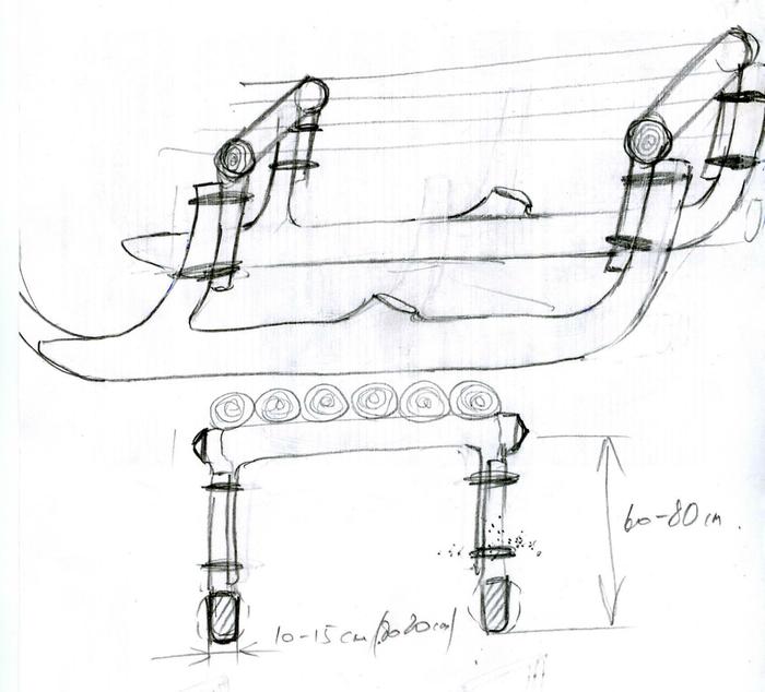
Drawing 1 - Possible design of the sledge
The usage of carts seems to me the least probable option. First, in the structure of the ruts there is no deepening repeating the form of a wheel that should have been left in the places where the cart stopped or moved jerkily. Second, a cart when compared to a sledge is much more demanding to the quality of the road. Carts cannot move across bogs. They require roads. It would not be right to assume the presence of roads at that stage of social development of Maltese society. They simply did not need them. The need for roads first appeared in the epoch of early states with their centralized authority and economy. It was not accidental that even later, at the construction of temples and caves ancient Malteses did not make access roads leading to the entrances. All they needed was limited to footpaths. Third, the ruts nowhere change their course sharply as it must have happened in case of using single axle vehicles. The radius of turn is never less than ten-twenty meters. Certainly, such traces could be left by primitive two axle carts the forward axle of which does not turn. But it is rather unlikely that having invented heavy four-wheel carts, people had not created and used the most simple in manufacturing and easy in movement two-wheeled ones.
The final answer to the question whether the ancient Maltese used rafts or sledges, in my opinion, may be given only after studying rock drawings from all over the world. Since swamps during this period of time were distributed everywhere very widely the need for such transport might arise in other places of the Earth as well. Therefore sledges, as an important item of everyday life, might be reflected in petroglifs. However, in a graphic representation sledges may look similar to boats.
This way the life of ancient Maltese was going on in daily work and cares until some very significant events took place resulting in the unique Maltese phenomena. But first allow me to step back and discuss some general issues.
From general geology we know that piedmont depressions and geosynclinal troughs framing platforms cave only in the beginning of the development and get filled by thick layers of deposits. Some time later the process of mountain building takes place over them and the collected deposits are squeezed out upwards and downwards forming so-called “mountain roots”. As a result actual mountains are formed. The same processes were taking place on Malta, but only in on a miniature scale.
The depressions marked on the surface back then by lakes and swamps, at the stirring up of the end contraction have turned into the areas of mountain building. In a matter of moments or days the heights of almost their modern size got formed on their place. Thus the mudlike bottom deposits formed on these territories got lifted up tens and hundreds meters high and covered, as after the flood, slopes and tops of newly formed hills. In a little more time as a result of continuing compression, the limit of plastic deformations of deposits was reached. Up to that time geological layers mainly formed flat gentle folds. After that faults started to appear.
Around the tops of the hills the systems of framing fractures appeared. The material which still had some plasticity when being squeezed in the centre of folded structure was getting squeezed out upwards along those fractures, raised the arch of the hill and thus the pressure was lowing. This process can be compared to pulling out of a telescope’s sections. Most likely, the formation of faults was accompanied by earthquakes. Simultaneously on weaker areas there were breaks through and emissions onto the surface of more plastic clay material, forming very unusual structures similar to the diatremes which are present in great number on Malta and Gozo. The only difference is that instead of kimberlites they were filled with dirt and fragments of the broken formations. Local geologists believe that these are the structures of carstic caves filled by deposits at the top. They call them collapse structure. However I am afraid that the situation is reverse. Their filling by material was taking place not from the above but from below under the pressure just like in the case with Neptunian dykes that are also found on Malta. Besides there are no major carstic cavities on Malta the arches of which might have fallen down. Carst is developed very poorly. All of this resulted in formation of coastal faults and the islands acquired an appearance close to modern.
A drawing number 2 can give a general idea about the mechanism of this process. A more detailed representation with connection to the local realities is supplied by four charts of the development of Dingli cliffs submitted in the appendix № 1.
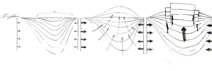
Drawing 2 - Schematic diagram of the relief evolution
A) The first stage. Gradual and slow end contraction. A depression develops.
B) The second stage. Activation of compression. Deposits, filling the depression are compressed and squeezed out
upwards.
C) The third stage. Compression exceeds the limit of plastic deformations of rocks and in the arch of structure
breaks appear through which it is sharply squeezed out upwards. It is similar to a cork or a valve being thrown
out of the bottle. Further compression causes only slow growth of the top of the hill as well as the growth of
the surrounding cliffs.
In the sea the process went in an opposite direction. The bottom was lowing involving the surrounding both big and small parts of the land. The lagoon islands went under water, having turned into gulfs and shoalinesses. The traces of them preserved around are the fragments of very characteristic coastal bars made of fragments of limestone cemented by red-brown hydrooxides of iron. These bars used to separate internal fresh-water pools from more salty water of coastal lagoons. They were formed in conditions so-called geochemical barrier which always exists in the areas of connecting of continental and sea waters. Iron that is present in fresh water in a dissolved condition when connecting with the sea water enriched with oxygen drops out as a precipitation of brown - red hydrooxides.
The process of this reorganization of the relief apparently captured all Mediterranean regions. Most likely it was then that the bridge connecting Malta and Gozo with Sicily fully or partly plunged under the water. It must have been populated with people for whom this event became a real flood. Simultaneously, many areas of the Mediterranean might have risen upwards while others might have plunged under water. They could be located both near the sea and far from it. Some islands might have disappeared, while others might have been formed. And then, on such newly risen from the bottom of the sea places the situation could be close to that on Malta. Probably many of the “cart-ruts” found outside of Malta were created then and have precisely the same nature.
I understand how difficult it must be for both experts and even non-experts to accept the submitted explanation. The reason is that nothing in our modern situation or in the recent history (with very rare exceptions) shows anything like this. On the contrary, the precise gauging of heights shows that tectonic processes go extremely slowly and imperceptibly for humans. Maximum growth is millimeters per year.
At the same time we know that in the history of the Earth there were epochs of changes. There were epochs when during a short time many things changed greatly: character and a mode of sedimentation, relief, climate, vegetation and fauna. Unfortunately geology does not possess any reliable and exact clocks. There is no method of definition of absolute age. Consequently, we do not know how quickly these changes were taking place in antiquity: in instants, years or millions of years. However we know that quite recently according to geological measures all over the Earth a process of mountain building took place which geologists name Quaternary block raisings. As a result of it the landscapes have undergone drastic changes. Huge territories were drained or plunged under water. There were sharp changes of the climate as well. So sharp, in fact, that many kinds of animals and plants had no time to adapt to them. Those changes have caused extinction of some of them, essential change of the areas of distribution of others, and seasonal migrations of the third. It certainly does not give us the right to assert that in the epoch of changes all was not the way it is now and that modern criteria cannot not be applied to the analysis of those changes at all. However, a possible connection of the events that took place on Malta with these periods of global changes should reduce the level of our resentment to even, at first sight, unexpected results and conclusions.
Summarizing everything that was said we should decide not to rule out a possibility of such catastrophes as the one that took place on Malta during the time of planetary reorganization. Besides we know that the Mediterranean region, this cradle of many early civilizations, was never tectonically quiet. Just think of the collisions which accompanied the whole history of Crete-Minot civilization. Think of its sudden occurrence, periodic destructions of all that was created and a mysterious end. Think of the eruptions of Stromboli or Vesuvius. Think of the constant sea and earthquakes. Malta is that rare case when due to the traces of ancient people’s activity it is possible to understand better what was going on. And now we will have a short interlude.
I shall not supply my readers with all proofs for the above-stated conception because, on one hand, one should have certain level of geological education for understanding of this complicated central moment of history. On the other hand, it would demand lots of illustrative material: geological and topographical maps, aero and space photos, other photos and block diagrams which would greatly increase the volume of this article. I shall reserve all this for another case. For now I am going to limit myself to the clearest and the easiest arguments.
As I already mentioned, one of the main obstacles for acceptance of my explanation concerning the nature of the Maltese relief are certain views accepted in the scientific world, and first of all among geologists. They are presented in the above mentioned book on the geological structure of Malta. Briefly, it is believed the geological block which subsequently became Malta has risen from the bottom of the sea and acquired the modern height 5-6 million years ago. All the following time the sun, wind, rains, and streams destroyed, washed away and dissolved it until the block got its modern appearance. One of the primary factors in this process is seen in the resistibility to destruction of the layers composing the Maltese section. Firm rocks get destroyed more slowly. Consequently we can see steep slopes and cliffs. Softer rocks are being destroyed faster, hence they form flat forms of relief.
It is easier to understand this when looking at the chart borrowed from the above mentioned book where the authors evidently presented their representations about geological structure and evolution of the Maltese relief (see Drawing 3).
The first stage: the block rose from the bottom of the sea. It was covered by the youngest limestone, that is, the upper coral limestone. Its basis was compiled of the most ancient limestone, so-called the lower coral limestone. Both kinds are considered the hardest in the Maltese section. On the drawing they are colored in green and pink colors. Between them there are softer globigerina limestone, which is painted in brown, as well as very soft calcareous blue clays, colored in the section by the same color.
Further, in the opinion of the authors, the lifted block underwent a stage of destruction. As a result the layers forming the Maltese section had been exposed in the valleys formed. On some sites erosion has completely destroyed the cover of the youngest layer (upper coralline limestone), while it still remains on the other sites and covers the tops of the cliffs.
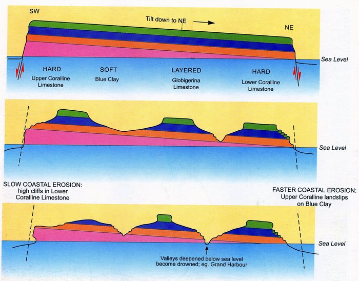
Drawing 3 - Schematic diagram of the Malta`s relief evolution by the book «Limestone isles in a crystal sea» by Martyn Pedley
It is clear that within the framework of this view it is impossible to explain how the cart-ruts could be simultaneously printed on both the young upper coralline limestone and the ancient lower coralline limestone. They could not be plastic at the same time with the difference in age reaching 20-25 million years (according to their theory). Besides they could not remain plastic during those 5-6 million years when not being under water. Let alone that coralline limestone is not plastic at all. If these limestones are really coralline it means that they were formed by initially firm constructions of hydroid polyps and bowls of mollusks. Those who saw coral reeves closely, understand, that there could be no prints or traces of carts or sledge left on them whatsoever. Hence, a compromise is completely impossible.
When I look at photos of a typical relief of Malta and Gozo, two of which are submitted below (photos 14 and 15), it is very difficult to believe that those cliffs are only the remains of that big block that rose out of the sea. It is hard to believe that all those enormous volumes of rock that used to fill the space between the cliffs were carried away by rivers and streams. The reason is that I do not see on their slopes any traces of the process which should have formed those cliffs. They are too smooth. There is no system of naturally formed, with certain intervals, alternating divides and valleys, covering them completely and penetrating into the most distant corners. There is no system which would provide carrying out of products of destruction from the whole surface.
Two photos of really ancient erosive relief (Photos 16 and 17) are submitted below for the comparison.
The first photo gives a good representation as an old and mature drainage system should look.
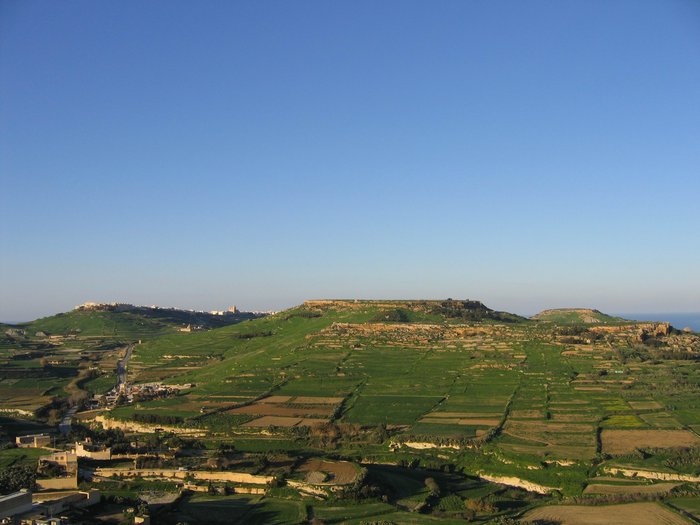
Photo 14 - A typical relief of Gozo. Hills with table-like tops. A view from the citadel to the north.
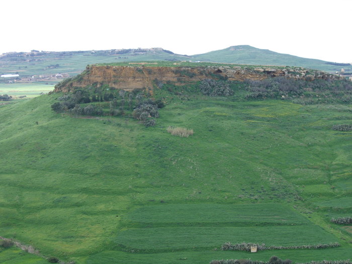
Photo 15 - A closer view of the slopes of the hill. A view from the citadel to the west.
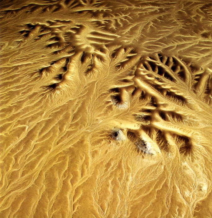
Photo 16 - Branching vadi in the desert near oasis Baharia. (a photo by Marcello Bertinetti)
Its main feature is a highly developed branching. Each water-current gets surrounded by inflows. The same thing happens with the inflows and the inflows of the inflows. This way the valleys form a complex hierarchical system like dendrites or roots of plants and develop from bottom upwards, gradually reaching into all corners of catchment’s basin, thus providing the process of carrying out of the products of destruction of rocks from everywhere, and, hence, the formation of slopes. Looking at the photo 16 one can tell that only the watersheds have not been touched by erosion. It is possible, that when the climate changes drastically again, and it starts raining in deserts, this process would go on. But for the present time all water-currents are “asleep”, and erosion has stopped.
The next photo 17 provides a close view of the slopes of cliffs generated by erosion.
In this picture the divides have been touched as well. Therefore they are not wide and round but rather narrow and comb-shaped. If one mentally continues this process in time it would become clear that the watersheds dividing these small valleys would go down until the corners of slopes would not become so smooth that carrying out of the material from them would eventually stop and the development of the relief would terminate. Then they would get covered by soil, grass, and trees. However it is obvious, that the arrangement of valleys and watersheds would not change essentially, and their initial rhythmical alternation on the slopes would be preserved as well.
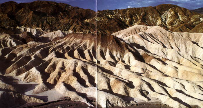
Photo 17 - The Valley of Death, Zabrisky-Point, California, USA (a photo by Marcello Bertinetti)
There is nothing or almost nothing like that on the submitted photos of typical slope surfaces of Malta and Gozo.
As if to prevent future mistakes the nature has created on these islands an example of 3-4 small sites with a classical erosive relief. One of them is shown in photo 18. One can note that in the foreground of the picture between the top and the bottom cliffs there is a strip of a slope strongly separated by erosion. It looks very similar to the fragment of the Valley of Death submitted above. In the background of the picture one can see gently sloping trough-like valley surrounded by a cliff. Its slopes are more similar to those seen in photos 14 and 15. Despite of obvious differences it is now believed that their origin is identical and erosive. In my opinion it is a serious mistake.
The occurrence of such sites with a classical erosive relief was caused by the fact that they began to rise above a flat surface of Malta prior to other cliffs. This process started at the time when the climate on the planet was much more humid and there was no lack of rains. These ravines were formed by water flowing down from the slopes. Such evolved from the ground forms of relief appeared to be the forerunners of the future reorganization of the relief. Completely similar slope both in its geological structure and the position between so-called lower and upper coralline limestone in the area of Dingli rocks (photo 20) does not have any traces of erosion whatsoever. It is not surprising because it was formed later when the climate became much drier
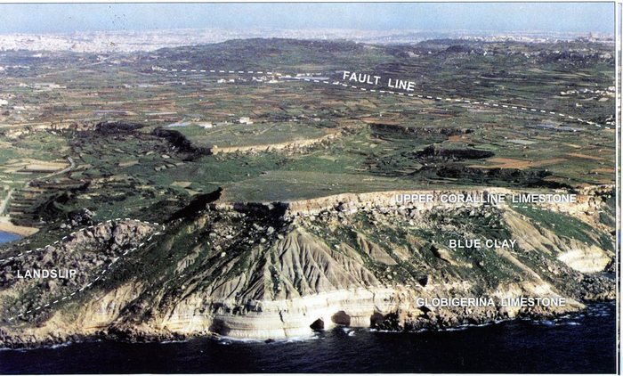
Photo 18 - Cape Ras il-Pellegrin (a photo by Jonathan Beacon from the book “Limestone isles in a crystal sea”)
Except for flat slopes in all submitted pictures illustrating the relief of the islands, one can also see the characteristic table-like tops. In M. Pedley's book it is told that such morphology of the hill tops testifies to the fact that they are erosive outliers of the mass of hard limestone. They were hindering the process of destruction of slopes and have become some kind of the reservation for softer layers underneath. Naturally, according to the above mentioned reasons I do not consider this explanation acceptable either. Personally I connect an origin of such cliffs with tectonic disturbances. These disturbances are represented in drawing 2 (В)
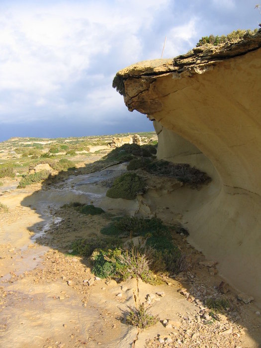
Photo 19 - This is how the disturbance looks now. It was due to this disturbance that a scarp on the top of Dweira cape was formed ( coordinates N 36.о 03,295 E14о 11,445). A photo of the author.
Look at the photo 19 taken on cape Dweira. It represents one of such cliffs closely. Its height is 2-3 m high. It is located on the top of the hill, near a modern quarry. It is interesting that the deposits that have become exposed in it (globigerina limestone) are precisely the same (not harder) as those on the slope below. But the cliff is there which means that it has nothing to do with the effect of armoring.
Have a closer look at the foundation of the cliff. Directly under the cliff on a fresh clay alluviation there is a small crack. It is even surrounded by bushes. It is a tectonic break along which the top part of the hill was squeezed out upwards and continues, I think, slowly rise even now. The fact that it is visible testifies that there are still some motions there. All other cliffs and scarps on the islands have precisely the same origin, including canyons. The origin of the latter is wrongly considered to be connected to the activity of water-currents. It is true however that some of them are really very similar to meandering valleys.
Why did not the geologists figure this out before? There are lots of different reasons. Mainly it is because they have confused the course and the effect. They see cliffs. They see rivers and streams between them. They see loose material carried away by water. And naturally they assume that it was so hundred, thousand, and millions years ago. Hence they view both mountains and valleys between them as the result of this process.
The geologists divide the local geological formations into two groups according to the hardness of their fragments: more and less hard ones. Then they search and sometimes it seems that they find in the character of slopes or in the very fact of isolation of this or that geological object in the relief an evidence of such selective destruction of rocks. It seems to prove the correctness of the approach, that everything was developed as a result of erosion. The cases where such law is not shown are usually put aside as uncharacteristic. “There could be many different reasons. It is obvious to all that differences in strenght should be seen in the erosion of relief”. A thought that they have exchanged the cause and effect simply does not occur to them. The thought that the water-current flows here only because of the mountains both big and small have grown around, thus, having formed lowering - natural low, which it occupied simply does not come to mind.
Another reason why geologists did not perceive cliffs and scarps on Malta as a display of tectonic activity was their complexity. They are far from having straight configuration in the plan. The fact is that traditionally geologists view the development of faults taking place not from the surface downwards, but from the depths upwards to the surface. They suppose that the source of crustal movement in the Earth's crust is somewhere in the heated top layers of the mantle on the border with lithosphere. Then, it is natural to expect that the faults which have reached the surface on such a distance from their source should be very smooth and rectilinear. This is how they are usually drawn. Having this in mind it is impossible to allow the existence of faults forming complex bends of the coastal line, or following the winding horizontals framing a valley or tops of hills. Therefore they searched for other explanation to such cliffs. This led them even farther away from discovering the truth. Besides the tectonic fractures similar to the one shown above, usually are not visible since the foundations of the cliffs are almost always filled up with taluses.
In justification of the Maltese geologists I can tell that 99 % of geologists would make precisely the same conclusion. And, maybe, only 1 % would have doubts and hesitate a little when drawing conclusions in what apparently seems a very simple and obvious situation. A mistake here is a system mistake. It reflects the problems existing in geological representations on the nature of tectonics and relief.
In order to support my suggestion I attach a photo of a few hills on Gozo Island from the site Google Earth (appendix 2). One can see many concentric belts of infringements along which the growth of heights was taking place and absolutely natural radial structures accompanying such processes.
So, we shall continue. After a catastrophe on Malta and Gozo many newly formed cliffs were covered with fresh and damp lake silts. The survivors inhabiting the coasts of reservoirs, people who happened to be in the areas of raisings, suddenly found themselves far from the water surrounded by marsh sludge. It is obvious, that they could do nothing else but to collect all their belongings and leave the place looking for a new residence by water. It is doubtful that they thought long. Suddenly the nature surrounding them became hostile. The lakes lowered and fresh water disappeared. They could no longer catch fish or water birds. Hippopotamuses and elephants had left in searches of water as well. Paradise life was over, and struggle for survival began.
What most necessary things would people of the Stone Age try to carry to a new place of settlement? Their dwelling places? It’s highly improbable. They were too heavy. Besides, there was no urgent need for them in the warm climate. It would have been easier to make new ones. However, it would not be reasonable to leave behind their sledges or little rafts which were kept somewhere by their homes and also appeared to be far from water. It was not easy to make them again. And they were essential for the inhabitants of the coast on a new place for hunting and fishing. Besides under the circumstances they could be used for evacuation. Looking at the depth of traces left by them one can understand that they were heavily loaded. Dragging of them required efforts of more than a dozen of people.
Hardness of this measure should not cause doubts in its possibility. In the antiquity people often resorted to “volok” so-called dragging a vessel for some distance across the ground. Only on a well-known route “From Varang to Greeks” there were some tens of kilometers of the watersheds of rivers which had to be crossed overland. And the weight of merchant boats loaded with the goods was far greater than the weight of Maltese sledges.
In the most cases the direction of ruts unequivocally confirms an assumption of resettlement. They go from mountains to lowlands, sometimes lowing on slopes as a serpentine as for example on site Naxxar Tat Tagra (photo 37). But sometimes it was impossible to descend straight down to the water because of the formed cliffs (site Ta Cenc) and then the track goes along them or in the opposite to the coast direction, around the cliff, to a place of possible descent.
On the southwest coast of Malta, in the area of Dingli rocks, between two tectonic disturbances having shown as cliffs an extended strip of land inclining to the sea (photo 20) was formed.
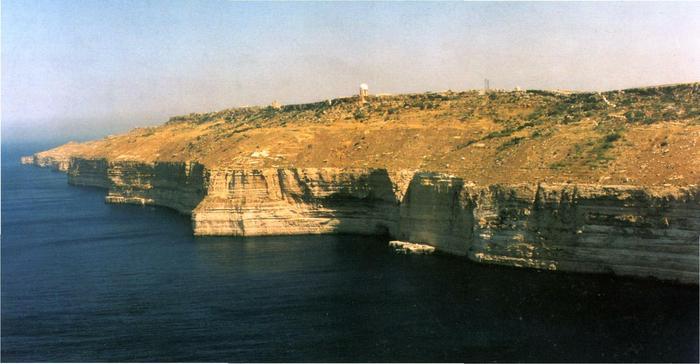
Photo 20 - Dingli cliffs. (A photo by Jonathan Beacon from the book “Limestone isles in a crystal sea”)
The bottom cliff that had formed after the catastrophe at the height was about a hundred meters high. It was an obstacle on the way to the sea. The top cliff with the height of a few tens of meters did not allow climbing up the mountain in order to climb down on the other side. Just opposite the site Clapham Junction (its photos are in the beginning of the article) the top cliff was almost vanishing. It was here that the people who were lucky to remain alive on this strip of land and did not sink in the sea with the lowered land could get out of the trap.
Having climbed to the flat top of the mountain covered with lake silts they went to the north in order to climb down to the foot of the height and to go further to the east towards the seacoast. The site Clapham Junction is located in the upper part of the valley through which they were climbing down (drawing 4). This is the reason why a few dozens of sledges met here. One can see their traces on photo 10. Close view at that site also borrowed from “Google Earth” is presented in appendix 3. Places with most of cart-ruts are shown by arrows.
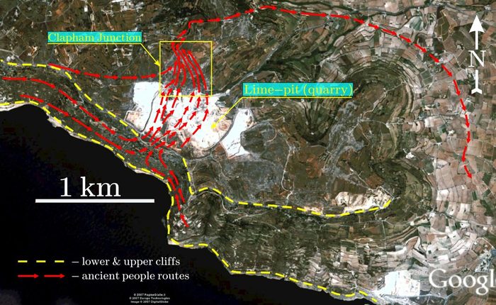
Drawing 4 - A top view at the site Clapham Junction from “Google Earth”. Supposed ruts of evacuation
As you probably remember, we mentioned ordinary and main roads represented on photos 3 and 6 accordingly. The difference is that the former were caused by dragging of one cart, while the latter were used by many carts. What is the reason of forming two kinds of tracks? In my opinion, if the laid track was used for the second and third time then in spite of the fact that it saved efforts in lining tracks each subsequent sledge or raft immersed in silt more and more deeply. Finally it came to a point when transport was halfway drawn in mud. Then the efforts in dragging it would have to increase greatly. Therefore people usually preferred not to use an old rut again and went in parallel to it. This is how till this day the scientists explain a mystery of many parallel cart-ruts which are close to each other. At the same time after they had overcome this difficulty and used the same track a number of times, then the legs of people and sledges stirred the dirt to the point when it became more liquid, and as a result more passable. Especially if sledges were dragged from the top of the slope downwards, as on Clapham Junction, each pass would push the dirt downwards the track, thus reducing its quantity and facilitating the movement of the subsequent ones.
When in the beginning of this chapter I mentioned the existence of extensive swampy spaces on Malta and Gozo prior to the catastrophe it probably seemed to many readers too far-fetched. Such attitude of the readers seems to be supported by the fact that the deposits which the local geologists attribute to lakes have extremely incidental and local distribution on islands and are considered no more than a curious phenomenon. On the territories marked by me in the southwest of Malta and the northeast of Gozo such deposits, in general, are absent at all. Does it mean that the assumption of the presence of swamps and lakes is not true, or may be, their traces - deposits - have disappeared somewhere? Before we try to answer this question let us discuss what kind of deposits we can expect at the bottom of such reservoirs.
It is obvious that in conditions of warm climate any fresh-water pools would begin to get assimilated by plants. The less was their depth and the calmer were the waves, the faster this process occurred. The bottom, the volume, and the surface of water were being occupied by various seaweed. On coastal shallows reeds, bushes and trees located. During their life dying off parts of plants – stems, leaves, and roots fell onto the bottom and gradually formed a layer of usual lake silt – sapropel. For certain, many of us had to clear the bottoms of our ponds from it. In spite of the fact that such silts become fine soils and even are used in an agriculture as fertilizers, excessive sapropel at the bottom of a water reservoir results in developing stagnant conditions and degrading of live organisms and plants occupying them. The first sign of trouble is bubbles of marsh gas rising from the bottom, which many have certainly observed standing by such reservoirs.
Thus, having assumed the existence of lakes on Malta in recent times, we have the right to expect that they might leave covers of organic silt or peat bogs on under spreading carbonate deposits generated during the previous lagoon stage of development of the depression. But then, after the catastrophe it was them (and not carbonate deposits which have turned into light modern limestone) that might have covered the height with a layer of black bad smelling dirt. And it was through this layer that the ancient people had to drag their sledges or rafts.
Let's have a closer look at what was happening. It is natural that the thickness of a layer of organic silt might vary in a lake. After the drainage took place the thickness of the cover of organic silts covering slopes varied in different places as well. In the places with thin layer of 0.3-0.5 m the runners of sledges have cut the cover and left traces on the under spreading carbonate silts. However, at the places where it was thicker their traces on the under spreading layer might not remain at all, or they were shown less clearly. Compare traces on photos 5 and 1. Bad quality traces in the first picture is not due to the fact they were not well preserved. On all sites which I visited the preservance of ruts as well as surfaces of limestone as a whole is very good. However, the quality of prints is a different thing, but to the fact that the sledges were dragged on a rather hart surface, probably formed by roots of coastal plants which did not get cut by runners but only curved under them. Hence, we can see the width of separate tracks increased 2-3 times. That creates a sensation that something rough, huge, and really prehistoric had been dragged here. Nevertheless the distance between the central lines of ruts remains 1.4-1.5 m as everywhere else. That is natural, since the size of sledges was the same. The pressure of a runner upon carbonate deposits was applied to the surface as though through a lining, hence the bad quality of the prints. When lake silt disappeared later (we will talk about that a little bit further) only those fragments of ruts which were printed on under spreading carbonate deposits remained accessible to the eyes of people. Hence, the result which always caused bewilderment among researchers: tracks disappear and occur again as though the thing that created them landed on the ground and then took off again. Originally they were unbroken and continuous, and resembled traces of a track cross-country vehicle or a tank that went straight over bushes, swamp or thickets of a reed, bypassing only very big obstacles.
Now we shall try to understand a rather strange feature of ruts - the absence of lumps of the squeezed out material on both sides. The reason for this is also in the nature of the cover of organic silt.
In normal conditions lumps are formed when any subject presses into clay-like masses. It can be for example a wheel or a runner. Then the underlying material can easily move to the sides. However, if the surface of the layer under consideration was not open and free but was under some other layer, as it is represented in drawing 5, it did not happen since the overlying deposits would not allow it.
Thus, we can explain not only the absence of lumps, but indirectly indicate the fact of the presence of some cover on calcareous silts.
Pressed out lumps were there for certain, but only on the surface of organic silt, but later they disappeared along with those organic silts. Carbonate deposits located deeper were not squeezed out under runners, but only moved apart to the sides.
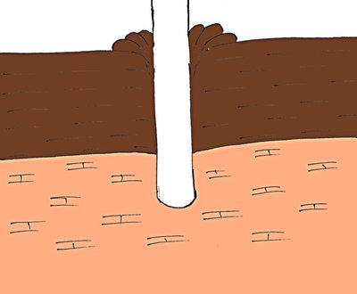
Drawing 5 - Deformation of plastic layers at pressing.
One more confirmation of the existence of a cover of organic silts in the past are the very ruts, more correctly, their remains. They were not washed away by rains. They have not cracked at drying. They did not slumped and were not closed right after being formed. All this became possible because right after passages of sledges they were filled by surrounding organic silt stirred up to the condition of dirt, and, thus, became inaccessible to all mentioned above influences harmful to them, till carbonate silt has not turned into limestone.
The last point among these arguments is the very character of the surface of limestone (see photos 4, 6, 21).
When in 2005 for the first time I saw a micro relief of the surface of limestone at the top of Dingli cliffs during one of the excursions on Malta, it sank very deep into my mind. It was very different from everything else that I happened to see in my geological experience. The surface of dense porcelain-like limestone almost deprived of clastic material (eluvium – geological term) was so fancifully rough, that now I would tell, that it reminded stiffened dirt. But then this definition did not appear to me.
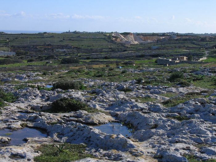
Photo 21 - A view to the northeast from a viewing platform on Dingli rocks. Malta island.
In 2006, being on Clapham Junction, I understood that a solution of its nature is one of the keys to solving the Maltese mystery as a whole. The fact is that all of its roughness is not the result of destruction and dissolution as it is officially considered now, but was caused by processes of moving of substance on the border dividing sedimentary layers (carbonate silts and organic silts) back in those times.
Top horizons of carbonate silts on many sites originally contained a significant impurity of finely dispersion vegetative material. There is nothing unusual here as the change of lagoon conditions for the lake ones in which organic deposits begin to prevail might have occurred here and there not very drastically. Thus, for some time the vegetative material might deposit together with carbonate, moving to lagoons from coasts due to washout of more ancient underlying sea deposits. Inside a layer, with the deficiency of oxygen, the organics was decayed by bacteria and turned to marsh gas which, being freed, formed irregular-shaped holes. Bubbles of gas were moving towards the surface and involved deposits containing them in this process. Filled with bubbles carbonate silts, by virtue of low density, in the movement upwards have resulted in formation of roughness on border of the division of layers: the various forms of lumps and holes (see drawing 6 and a photo 22,23)
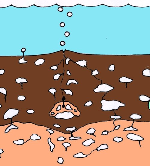
Drawing 6 - Formation of gas in the deposits
At the same time one cannot allow that such surface might exist directly on the very bottom of the reservoir on the border with water. In the liquid environment the mobility of finely dispersed deposits like carbonate silts is so high, that even at absence of current in places of a release of bubbles at the surface of the bottom is only slightly raised (remember the bottoms of highly silted reservoirs). Such contrast forms which sometimes seem almost torn off the basis might have been formed only inside plastic and motionless cover what organic silts were.
In those places where carbonate deposits underwent deformation due to tectonic motions and small cracks were appearing on their surface, the bubbles of gas, choosing the easiest way, rose along them. Captured by this process carbonate deposits formed on the output of the crack small lumps on both sides (see photos 22 and 23). The connection of these processes with tectonics proves to be true by the natural character of their arrangement reflecting the structure of a dynamic field in the given place. By the way, it was finding them that suggested me an idea that the nature of a micro relief of limestone is not connected to erosion, but to the processes of generation of gas in the deposit. First of all it was seen in very specific kind of a crack between lumps.
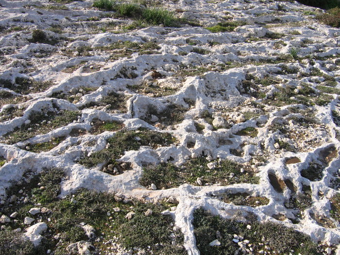
Photo 22 - Micro ridges and crevices on the site Clapham Junction. Malta island.
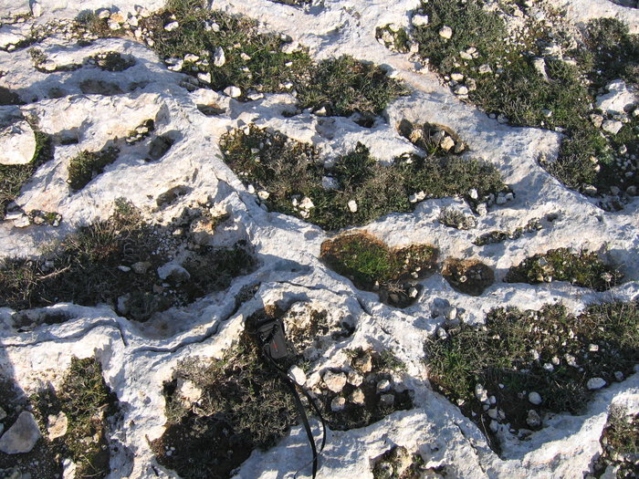
Photo 23 - Micro ridges and crevices on the site Clapham Junction. Malta island.
On some sites the freeing of gas in deposits was so plentiful that the formed rock began to resemble volcanic pumice. A vivid example of it is a dolmen represented in photo 24. Further such kind of limestone − porous, with a characteristic micro relief of the surface − will be referred to as swamp limestone, but we shall remember that it carbonates base originated redeposition from sea deposits.
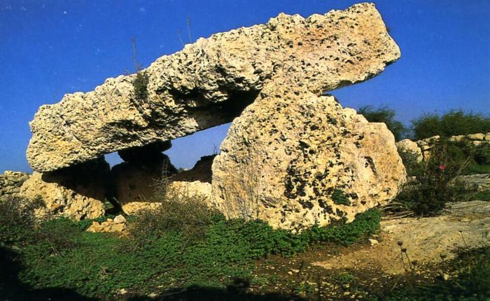
Photo 24 - Porous limestone in dolmen. (Photo by Daniel Cilia from “Malta prehistory and temples” by David H. Trump)
On those sites where there was little impurities of organics in carbonate silts, generation of gas did not occur and the surface of limestone has greater flatness (photo _), but this does not mean at all that there was no cover of lake silts.
So, we need to find out where it has gone to.
Attentive readers have probably noticed that among numerous pictures of ruts there is hardly any soil on the surface of limestone. There is only poor vegetation which is located basically in holes and lowering filled by clay. This implies that climatic conditions of Malta were recently such that the soil layer, formed from dying off parts of plants, practically did not develop. It is quite understandable because in conditions of desert climate the vegetation develops very poorly. And consequently, the processes of processing and oxidation of died off vegetative material go quicker than its accumulation. It means that even if the surface limestone used to be covered with a layer of soil which had remained, for example, since more humid and richer in vegetation periods, in existing droughty conditions it would degrade and in some time it will disappear completely. Microorganisms will eat up all organic component of ground and transform it into carbonic gas. It will simply evaporate.
This is precisely what has been taking place during last thousand years with a cover of lake silt on Malta and Gozo. This layer, almost all consisting of vegetative deposits has disappeared, and clay, sand, and fragments of rocks scattered in it were descended on the surface of under spreading carbonate silt which have later turned into limestone.
All of this is also fully applicable to a soil layer advanced on the land back then. It also degraded but it contained a lot of clay and consequently “burning out” of an organic component has not resulted in an exposure of under spreading limestone and consequently was not so obvious.
This process is not unique. The same thing happened with soil in Sahara and other deserts and continues to happen now in steppes and savannas, everywhere, where there is not enough moisture for sufficient reproduction of vegetation. But all of this occurred later, hundreds or thousand years after the catastrophe. Now we will turn back to the events that were taking place right after it.
So, fresh deposits which have not lost their plasticity appeared on tops of hills and plateaus. Under the influence of the wind and the sun they began to dry up. First of all this happened to a layer of organic silt, and then to under lying carbonate silts. Evaporation of water from the surface of deposits caused inflow from the depth of solutions saturating them which were enriched with various combinations, first of all, carbonate of calcium. This mineral makes a basis of any carbonate deposits including limestone and can be partly dissolved in water. It is this mineral that when precipitated from the solutions forms during thousands of year well known stalactites and stalagmites in caves, as well as absolutely fresh and fragile tubules-icicles under recently erected concrete bridges and roofs.
The latter phenomenon shows that formation of thin crust of carbonate can happen very quickly - in weeks and months time. The flow of mineralized solutions from below caused re-crystallization of deposits, represented by the various biogenic deposits: microscopic bowls of plankton, fragments of corals and bivalves, fragments of echinite, etc. As a result newly formed carbonate of calcium began to adjoin on their surface in the form of crusts. On one hand it resulted in the deterioration of deposits. On the other hand it connected them among themselves, as if gluing together which led to gradual loss of plasticity. All of this including the thinnest capillary channels through which the inflow of solutions from the depth occurred is well visible under a microscope when looking at thin cuts of such limestone.
Thus gradually in the process of drying of carbonate silts on surfaces the crusts began to form and thicken, representing not simply dried up carbonate deposit but strong limestone – the rock in which irreversible changes took place preventing its return into an initial plastic condition even when surrounded by water.
For many it would seem surprising that such transformation of “clay” into stone took place in normal conditions without high temperature and pressure, within short time and directly under people’s feet. Nevertheless, it was so. Due to this phenomenon tracks stiffened in limestone have reached our time, and we can restore the events that took place some thousands years ago.
This said our readers can ask a fair question. Should not there be some traces of feet of those people who dragged these rafts-sledges on the surface of limestone along with tracks there? Or they somehow disappeared? No, they have not disappeared. They are right here, but nobody perceives them as traces of people’s feet. And it is not surprising, because the quality of prints is such that nobody ever guesses what that was. The situation was aggravated also due to the general direction of thought of the researchers convinced that the tracks were the result of mechanical hollowing or wearing out of hard limestone. Even if they had found something similar to a footprint they would have explained it as some natural phenomenon, created by aeration or dissolution.
If we think of conditions in which the prints were created, then a discovery of a quality footprint would be an exception rather than a rule. Think of what can remain after a person’s walking on clay knee-deep in thick marsh dirt that could be even overgrown by moss, reeds or seaweed. Besides, the person was not simply walking but dragging step by step together with other people an extremely heavy and slow sledge using something similar to ropes. Besides, the sledge was leaving behind deep tracks and pushing a mountain of dirt ahead of itself like a bulldozer. It is nothing like a barefoot walk on the beach on damp sand. But this is not all. Bubbles which filled the top layer of carbonate silts did not serve the formation of a high quality prints either. Besides the upper layer of carbonate silts could be half-liquid which means that a person had to pull out his legs would not leave any traces except for small roughness.
Erosion has played its role in destruction of prints as well. Each time after the rain prints were filled by water which dissolved their sides and made their borders less and less distinctive (photo 26).
But in the places where limestone is denser and ruts have better quality, the holes reminding the form of a human foot are much better visible as well. Look at the submitted photos taken during very brief survey of the sites.
Photo 25 was taken at the site in St. Guan. In the left half of picture one can clearly see some oblong holes reminding the form of a foot. Orientation of these prints varies. It looks like a man walked on the same place, probably, crossed the track. The length of the print is a little bit more than 30 sm. In the picture there are 26 single prints from the same site with signs of erosion of the sides. Photos 27 and 28 represent chains of traces from site St. Pawl, Naxxar, tat-Tagra. Now the task is to find prints of high quality, and at the same time to look for traces of animals: hippopotamuses, elephants and hoofed animals. And, by the way, the traces may be found not only by to the ruts.
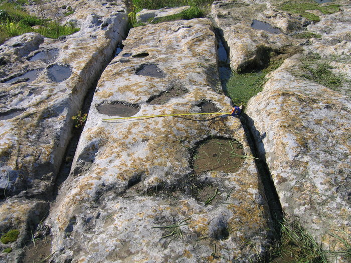
Photo 25
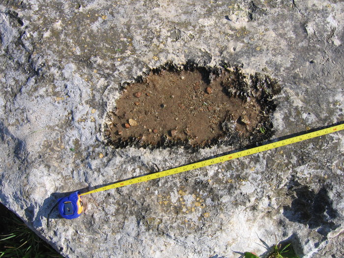
Photo 26
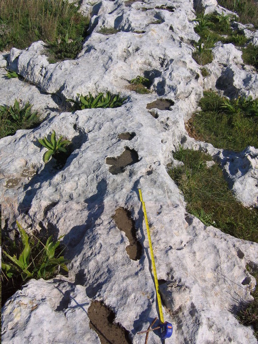
Photo 27
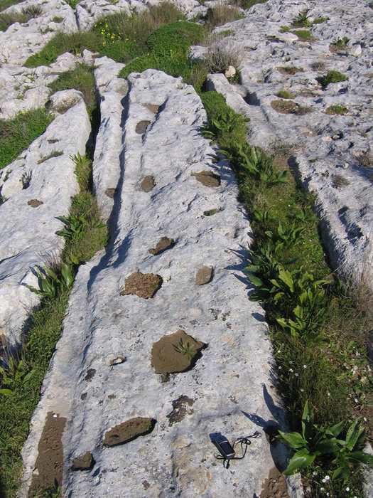
Photo 28
Photos 25-28 - Traces of people (?) from the site San Guan (above) and San Pawl tat-Tagra, Naxxar (below).
Now we will discuss temples and man-made caves. They are also connected to the catastrophe that took place back then and in many respects their occurrence and appearance owes to it.
As we already mentioned irreversible processes of hardening began in carbonate deposits that were lifted above the surface. Clearly, the direction of this process went from the surface down. First a thin crust was formed all over deposits, then it became thicker and thicker. Besides, all of this was happening under a layer of organic silts, which by then had dried up and, most likely, turned into usual soil.
May be, ancient people discovered this phenomenon, which was going on right under their legs, when digging holes or tombs. They started wittily using it. They began to make caves and to use the hardened strong top layer of limestone as natural ceilings. In that case they had to break through hard stone only at the entrance. Lower adjournments were much softer, and they could dig there using bone or even wooden scrapers. The importance of this was obvious to the people of Stone Age.
Examples of such constructions are Cave Dwelling (photo 29) and underground temple Xaghra Circle. In the photo supplied below one can see that ceiling is sustained enough and in comparison to the sizes of the cave is rather thin, only about 40-50 sm. Most likely, during the creation of the caves it was thicker, but soft adjournment, which were under spreading incrustation, fell off. The same way the roof on the sites where the spans between the walls were too big could fall off.
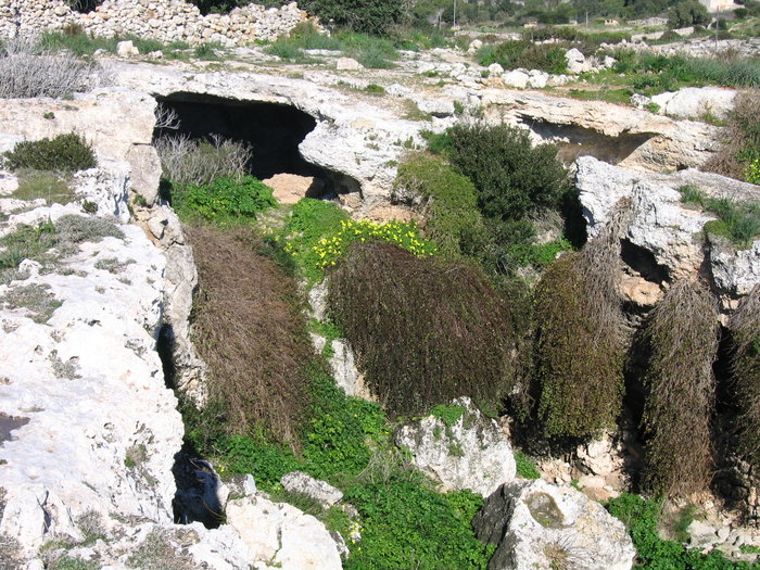
Photo 29 - Cave Dwelling
Probably it was caused by the fact that the massives left for the support of the roof (pillars) could not maintain the weight because deeper deposited adjournment from which they were formed have not gained necessary durability yet.
The same kind of thin and persistent ceiling is seen in the reconstruction of temple Xaghra Circle in the book “Malta. Prehistory and Temples” by David H. Trump.
The layer of hardened incrustation can be also seen in the structure of many other artificial caves: for example in tombs from Xemxija (photo 30).
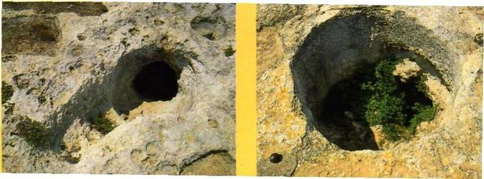
Photo 30 - Typical entrances to caves (tombs)
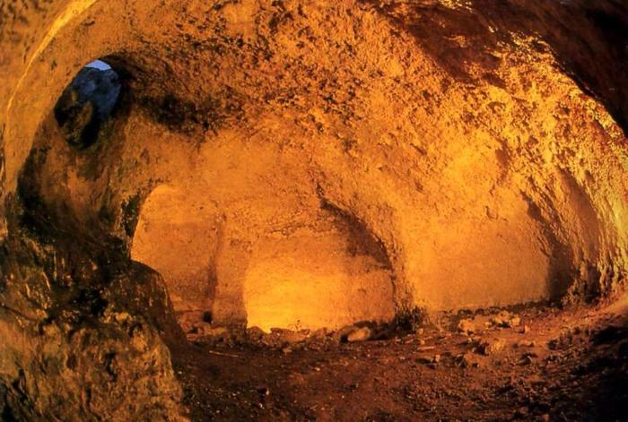
Photo 31 - Inside view of one of the caves in Xemxija
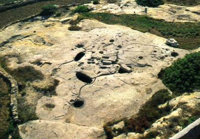
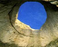
Photo 32 - Misqa tanc. Right: the top view towards the mouths of tanks.
Left: a view at the mouth from below, out of the cave. (All photos by Daniel Cilia from “Malta prehistory and temples” by David H. Trump)
When I first closely saw numerous, accurately cut holes of the different forms on the site Misqa tanc, leading into underground cavities (Photo 32) it looked to me very similar to how wasps eat away an apple from within having made a small hole in its skin.
Now, touching strong calcareous walls, nobody thinks that when these caves were dug out, the material was no harder than clay and could be dug by a shovel.
Now we shall have a look at the temples. Almost all of them, as well as caves, are located on the drained spots in the area of development of so-called coral limestone, or according to our definition “mash limestone”.
Another witty discovery of ancient people was the usage of hardened layer for construction purposes. They have guessed to tear off hardened crusts from softer foundation and used those plates as building blocks for walls.
Let's look at Ggantija, the biggest and well preserved representative of prehistoric temples. Its external walls are made of big plates turned on the sides. The plates are made of porous bright brown limestone (photo 33 and 34). Their thickness is about 0.5-0.6 m, and the weight reaches 15 tons. It is that hardened layer.
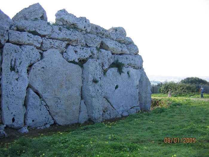
Photo 33 - The northern wall of Ggantija. (Gozo Island).
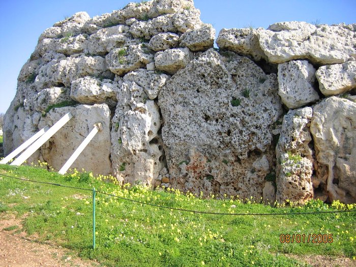
Photo 34 - The northern wall of Ggantija. (Gozo Island).
Top and especially bottom surfaces of plates are rough. They also contain plenty of cavities. A vivid example to this is the biggest plate in the centre of the bottom picture (photo 34). This fact rules out an assumption of some scientists that at the extraction of the plates the ancient people had to hollow them out along the bedding planes of the rock. Such surfaces are usually much smoother. It is quite clear why: they used to be the bottoms of reservoirs before.
This version hasn’t appeared accidentally. The matter is that on plates there are no traces of the tools used to hollow those plates out the massive!!! The situation is paradoxical. You see, nobody on Malta could repeat such thing since those ancient people did it.
In numerous quarries of the Roman period, let alone the modern excavations when people had bronze and iron it is always visible how the blocks were torn off from the massive. Besides, the size of these latter blocks is quite manageable. They weigh 300-400 kilos and are convenient for taking out, transporting and laying. An example to this is photo 35. For an estimation of the sizes of blocks I will tell that the depth of this quarry is about 0,5 m.
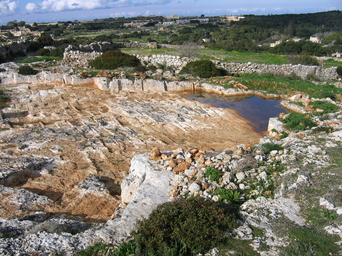
Photo 35 - Punic (Roman) quarry on the site Clapham Junction.
The solution is ingeniously simple. Having hollowed small holes along a prospective border of the plate along a small tectonic fracture or a scarp, ancient people stuck short ends of logs under a firm layer and pressing on long ends operating with them as levers they tore off crusts from under spreading masses of deposits that had not hardened yet. Then they turned the blocks vertically. They did it directly on the construction site or nearby. Thus the amount of labor at the erection of the walls was minimal. Ancient people have once again shown their natural wit and rationalism, having used a unique situation created by nature.
Look at the photo of blocks of Ħagar Qim temple submitted below (photo 36). In the foundation of the blocks one can clearly see big semicircular lunules. In the drawing located below it is shown how they could have been formed.
This assumption came to my mind before I read an above mentioned book by David H. Trump. You can imagine what a pleasure it was to find a confirmation to this idea. It appeared that attentive archeologists found some holes at end faces of some blocks resembling marks from logs made a long time ago. For clear reasons they could not guess that these were the prints from logs on the rock, that had not completely hardened yet, when tearing off the incrustations. They thought that it was the result of aeration of limestone in places of applying logs at transportation of blocks. Now this small riddle has received its solution.
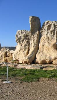
Photo 36 - The blocks of the southern wall of Hagar Qim. Traces of logs at the foundation of the blocks
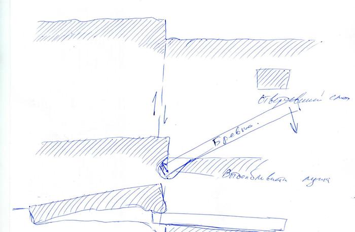
Drawing 7 - Tearing off the blocks
The indirect evidence of the fact that the plates were extracted directly on the construction site is also Ggantija. In the northern wall of the temple a number of pieces stand in succession on short and most inconvenient for installation side, with the same left bottom corner being broken off (photo 33). It is hardly an accident. If the plates were brought from somewhere else, in the process of transportation it would not be difficult to put them on a steadier and longer side. Then it would be easier to position the broken corner at the top. But it was not done this way. A possible explanation to this is that they were extracted directly on a building site, along the line of a future wall. Tearing off one edge of a plate and lifting it up made an opposite one the foundation. Certainly, it does not mean that all blocks were extracted and established as parts of a wall by one movement. For certain some plates got broken into pieces which were used for building the walls up or for filling the spaces between the walls. Some were extracted somewhere nearby and dragged by skating rolls but whatever the case they were not brought from afar.
The thing that ancient people avoided unjustified hard work follows from the fact that the big blocks were used only at the construction of the bottom walls. Even at the construction of Ggantija where the height of walls reached 7 m and the construction could easily take the second row of plates, people used only small blocks convenient for lifting up. It would seem that the sanctuary must be as impressive as possible. Why to pay attention to such trivialities as lifting big blocks up? It should not have created major difficulties – only building an extra higher embankment and a little more efforts. However they measured efforts with expediency. It was easier to establish one big plate in the bottom row instead of several small ones, and then add the next row composed of many small blocks instead of one big one.
It seems that the builders of temples preferred huge plates due to practical instead of ritual reasons. And the reason is simple. It was easier to get and establish big blocks than equivalent mass of smaller ones. Some extra work during preparation paid off by simplicity of lifting and installation. I will not be surprised if some day it would be decided that “temples” were not cult constructions but rather very unusual dwellings or refuges.
It is interesting to note that the builders preferred to use at the construction of external walls of the temples mostly very porous kind of limestone instead of dense without pores. It is possible, that it was because of lower density of such limestone it was possible to tear off thicker and hence bigger plates with lesser risk of breaking them since they better maintained their own weight.
The other reason could be that porous superficial layer hardened faster than under spreading less porous deposits, and thus, it was easier to tear it off. Therefore the temple sites were being chosen near the development of such differences of the rocks called by us “swamp limestone”. This fact also explains geographical connection of “cart-ruts” and temples. The former could be printed only in such limestone, the latter could be made only of such limestone.
Another kind of limestone was used for construction of internal walls of prehistoric temples. It was characterized by almost full absence of pores and greater softness. It is considered that so-called globigerina limestone is widely spread on Malta and Gozo. Nowadays due to the ease of its processing it is used for manufacturing building blocks for almost all constructions on Malta. But if we continue a thought of the adherence of ancient people to practicality, it is doubtful that these blocks were extracted and brought from afar. It seems to me that they were also extracted on the same sites but only from less hardened adjournment spreading the removed plates. After processing, alignment and adjustment they were established on their place where they completely dried up and hardened. May be, it is due to their softness and simplicity of processing, they are always much better processed than the plates from porous limestone. Moreover, it is possible, that carvings, that such blocks are so frequently decorating, was made on raw stone, and widely advanced dot figures for an ornamentation of the surfaces of stone might be done not by an incisor but by a stamp by hammering dots onto a surface.
Doubts that this it not globigerina limestone are caused by the fact of their high rigidity. Indirectly, it is seen in the fact that they much more stable towards atmospheric influences. According to information given by our guide this became clear after some original blocks from the interiors of temples were replace with their copies made of globigerina limestone extracted in modern quarries. This was done for the purpose of preservation of samples of the carvings of Neolithic period. Very soon it became quite clear that they would not last even for a few decades, let alone hundreds or thousands of years. I think that the reason is not acid rains, but that both porous, so-called coralline limestone, and more dense underlying deposits are a product of later re-depositioning of ancient carbonate deposits.
This process was taking place in shoaliness and partly in lagoons which preceded lakes and swamps. It is seen in many geological features of components and structure of limestone on micro and macro levels, which I will not discuss now. The result of this process is similar to that which occurs to fresh snow after being processed by the wind. From friable it becomes dense. This is the way particles of deposit behave as well. In the conditions of benthonic currents they are washed and densely stacked to each other almost without leaving any emptiness. Much later, after drainage these deposits became subject to intensive carbonization. As a result their density and hardness got even higher. This brings us to a conclusion that replicas should be made of limestone extracted from small depth somewhere near the temples, instead of digging them in modern quarries.
Another unexpected evidence of the birth of Malta and Gozo was found in the book called “Malta prehistory and temples” by David H. Trump. During the excavations in the area of Scorba temple in the cultural layer which is more ancient than the temple itself the remains of the walls made of unburnt clay bricks were found. This fact puzzled the archeologists who could not understand why would people use clay bricks when having plenty of stone around. The answer is simple. Just remember a suggestion made in the beginning of the second chapter about the absence of stones on the islands prior the reconstruction of the relief. There was no building material around besides clay.
In the end I would like to disseminate doubts in a possibility of fast transformation of carbonate silts into limestone. It appears that ancient people knew about it and used not yet hardened carbonate material as astringent when constructing temples. Apparently, right inside a structure they took not yet hardened material lying under the removed plates, mixed it with water and used as plaster to smooth the roughness of the walls. Traces of this work were pointed out by archeologists in many temples. Besides they used such solution as a basis when making floors inside the temples. They added fragments of limestone and building garbage into that solution. After alignment, tamping and drying they had the covering similar to limestone in its durability which archeologists call torba-floors.
If my assumption concerning the nature of blocks of the walls of the Maltese temples proves to be true, then it will be necessary to check up other places in the world for detection of a similar geological situation where so-called cyclopean masonry from limestone was used in ancient constructions. It is possible that in other places the extraction and processing of blocks was made from not yet hardened limestone as well, or that people also tore off hardened incrustations.
The last issue which cannot be avoided is the age of the events. To my great regret I cannot give a more or less certain answer to it using the help of any analytical methods. I can only try to do it, having carried out appropriate research but there is no guarantee that it will be successful.
Existing radioisotope methods frequently yield extremely inconsistent results and consequently the dates received by them usually are not determining for geologists and archeologists, and basically are used as additional ones if they do not contradict a conclusion of a researcher.
For now we will have to be satisfied with existing opinions about the age of the temples and some well-known materials.
If our assumption is true, then available range of dates of erection of the temples is most likely connected to the inaccuracy of the method of dating. Crust, for certain, acquired durability and thickness with identical speed over the whole land, that is, could be used for construction approximately at the same time. Only low coastal areas where this process might go more slowly, owing to a high level of subsoil waters could be exception. Grey Skorba is considered the most ancient temple - 4500-4400 BC. Tarxien is considered the youngest - 3150-2500 BC. Roughly we would accept that the temples were erected during an interval between 2 - 4 thousand years B.C.
Another date to which I would pay closer attention to is the date of the Flood - 3500-2300 B.C. according to different variants of the Bible chronology.
It seems to me that the most probable time of the catastrophe and the construction of temples and caves is the end of the fourth - the beginning of the third millennium B.C., i.e. about 5000 years ago. This was happening during “shock” reorganization of the relief of the whole planet and was reflected in legends about the flood found practically among all nations. As a result enormous changes took place on the face of the Earth and in its climate. The latter became neither colder nor warmer, as modern researchers usually say. It became more differentiated, both according to latitudes and seasons. It became much hotter in tropics and subtropics, and much colder in high latitudes. Distinctions between winter and summer became more drastic. It has caused disappearance of numerous kinds of animals and plants and a change of landscapes. These processes continue even now but at much smaller rate. It was reflected in life of ancient people. They had to adapt to new, much more severe conditions of existence. So-called Neolithic revolution came as a consequence of it. As a result the first civilizations appeared and “Historical time” began.
The experience of Malta shows that if right after the catastrophe people somehow adapted to the changes of the world surrounding them and even built great constructions, later their socium ceased to exist. It is possible, though highly improbable, that it was caused by some random factors - epidemics, poor harvests, or attacks of enemies. Most likely, it was caused by continuing changes of the climate towards more droughty one. It became possible to survive in such climate only later when islands got occupied by people from the continent who had wider experience and worldview and knew how to conduct agriculture even in such adverse conditions.
The third and the earliest date, 10 thousand years ago - the beginning of Holocene − seems to me the least probable. The reason is that if the raising had taken place before the epoch of droughty climate, then fresh and soft deposits covering the drained territory would have very quickly undergone erosion. And then the present erosive relief would be advanced on slopes of the heights not in some places as it is the case now but everywhere. But it is not so, thus, the reorganization of the relief and sharp change of the climate took place simultaneously.
In the end of this part I will remind of two photos: the tracks leading into the sea and the tracks ending at the cliff (Photos 8 and 9).
Everything is very simple. During all of the subsequent time the tendencies designated in the relief at the catastrophe continued to develop. Since the forces which had caused it did not disappear and continued to operate, the heights continued to grow, being put forward along old and new faults-scarps while the bottom of the sea around continued to low.
During this period of time the highest point of the relief might have grown two or three times. This is how the cliff which has uplifted a track on photo 9 was formed. At the same time there was constant struggle with changing success between raising and lowering spots at the border of the sea and land. As a result the coastal line is closer in some places and more removed in others. On the sites with the ruts leading into the sea we can see a phase of the sea approach. Certainly nobody dragged anything under the water. That part of the rut got hardened when being still on the surface. It went under the water thousands of years later.
On Malta there are also other evidences of these tendencies. From the times of Romans the coastal line has receded more than a kilometer in area of Mars. And at same time small islands in the gulf of St. Thomas and Marsaxlokk went under water. So the surface above and under the water became such because they developed in different directions. Some people’s approach viewing the surface of the Earth pretty much as a static system periodically drained and flooded by water due to the changing of its quantity in oceans is seriously erroneous. In fact it is an absolute opposite.
In last part of this article we shall consider in more detail some most interesting Cart-ruts sites.


